Piégut-Pluviers
| Piégut-Pluviers | ||
|---|---|---|
|
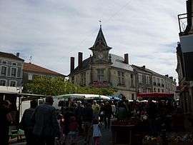
Town hall | ||
| ||
 Piégut-Pluviers | ||
|
Location within Nouvelle-Aquitaine region  Piégut-Pluviers | ||
| Coordinates: 45°37′25″N 0°41′25″E / 45.6236°N 0.6903°ECoordinates: 45°37′25″N 0°41′25″E / 45.6236°N 0.6903°E | ||
| Country | France | |
| Region | Nouvelle-Aquitaine | |
| Department | Dordogne | |
| Arrondissement | Nontron | |
| Canton | Bussière-Badil | |
| Intercommunality | Périgord Vert Granitique | |
| Government | ||
| • Mayor (2008–2014) | Didier Vignal | |
| Area1 | 18.11 km2 (6.99 sq mi) | |
| Population (2008)2 | 1,216 | |
| • Density | 67/km2 (170/sq mi) | |
| Time zone | CET (UTC+1) | |
| • Summer (DST) | CEST (UTC+2) | |
| INSEE/Postal code | 24328 / 243360 | |
| Elevation | 216–310 m (709–1,017 ft) | |
|
1 French Land Register data, which excludes lakes, ponds, glaciers > 1 km² (0.386 sq mi or 247 acres) and river estuaries. 2 Population without double counting: residents of multiple communes (e.g., students and military personnel) only counted once. | ||

Piégut-Pluviers is a commune in the Dordogne department in Nouvelle-Aquitaine in southwestern France. The commune is located 45 km (28 mi) from Angoulême, 65 km (40 mi) from Périgueux and Limoges and 200 km (120 mi) from Bordeaux.
Population
| Historical population | ||
|---|---|---|
| Year | Pop. | ±% |
| 1962 | 1,532 | — |
| 1968 | 1,545 | +0.8% |
| 1975 | 1,504 | −2.7% |
| 1982 | 1,527 | +1.5% |
| 1990 | 1,471 | −3.7% |
| 1999 | 1,313 | −10.7% |
| 2008 | 1,216 | −7.4% |
History
In Gallo-Roman times the place was called Podium Acutum. The castle was destroyed by Richard Lionheart in 1199, only the tower is still to be seen. The market on Wednesday morning has been held here since the seventeenth century.

Tower of Piégut
See also
References
External links
| Wikimedia Commons has media related to Piégut-Pluviers. |
This article is issued from Wikipedia - version of the 11/9/2016. The text is available under the Creative Commons Attribution/Share Alike but additional terms may apply for the media files.