Petrus Plancius

Petrus Plancius (1552 – May 15, 1622) was a Flemish astronomer, cartographer and clergyman. He was born as Pieter Platevoet in Dranouter, now in Heuvelland, West Flanders. He studied theology in Germany and England. At the age of 24 he became a minister in the Dutch Reformed Church.
Because of fear of religious prosecution by the Inquisition Plancius fled from Brussels to Amsterdam after the city fell into Spanish hands in 1585. There he became interested in navigation and cartography and, being fortunate enough to have access to nautical charts recently brought from Portugal, he was soon recognized as an expert on the shipping routes to India. He strongly believed in the idea of a North East passage through North America until the failure of Willem Barentsz's third voyage in 1597 seemed to preclude the possibility of such a route.
Cartography
In 1592 Plancius published his best known world map titled "Nova et exacta Terrarum Tabula geographica et hydrographica".[1] Apart from maps, he published journals and navigational guides and developed a new method for determining longitude. He also introduced the Mercator projection for navigational maps.
Plancius was one of the founders of the Dutch East India Company for which he drew over 100 maps.
Plancius was closely acquainted with Henry Hudson, an explorer of the New World.
Plancius prepared the map, Exacta & accurata delinatio… regionibus China, Cauchinchina, Camboja, sive Champa, Syao, Malacca, Arracan & Pegu, published in Jan Huygen van Linschoten’s popular book, Itinerario (1596).[2]
Uranography
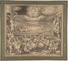
In 1589 Plancius collaborated with the Amsterdam cartographer Jacob Floris van Langren on a 32.5-cm celestial globe, which, using the sparse information available about southern celestial features, for the first time depicted: Crux the southern cross, Triangulum Australe the southern triangle, and the Magellanic Clouds, Nubecula Major and Minor.
In 1595 Plancius asked Pieter Dirkszoon Keyser, the chief pilot on the Hollandia, to make observations to fill in the blank area around the south celestial pole on European maps of the southern sky. Keyser died in Java the following year – the expedition had many casualties – but his catalogue of 135 stars,[3] probably measured up with the help of explorer-colleague Frederick de Houtman,[4] was delivered to Plancius. These stars appear as 12 new southern constellations,[4] on a 35-cm celestial globe designed by Plancius in late 1597 (or early 1598) and produced in collaboration with the Amsterdam cartographer Jodocus Hondius the Elder. The 12 new constellations (mostly referring to animals and subjects described in natural history books and travellers' journals of his day) are Apis the Bee (later changed to Musca by Lacaille), Apus the Bird of Paradise, Chamaeleon, Dorado the Goldfish (or Swordfish), Grus the Crane, Hydrus the Small Water Snake, Indus the Indian, Pavo the Peacock, Phoenix, Triangulum Australe the Southern Triangle, Tucana the Toucan, and Volans the Flying Fish. (The Southern Triangle and Southern Cross were reported as asterisms by earlier navigators and appear on earlier charts,[5] but the globe of 1598 is the first surviving source that plots their locations reasonably accurately.) Also notable is the inclusion of Achernar as Alpha Eridani.
These constellations, together with the constellation Columba illustrated by Plancius on his large wall map of the world of 1592, were then incorporated in 1603 by Johann Bayer in his sky atlas, the Uranometria.
In 1612 (or 1613) Plancius introduced the following eight constellations on a 26.5-cm celestial globe published in Amsterdam by Pieter van der Keere: Apes the Bee,[6] Camelopardalis the Giraffe (often interpreted as a Camel),[6] Cancer Minor the Small Crab, Euphrates Fluvius et Tigris Fluvius the Rivers Euphrates and Tigris, Gallus the Cock, Jordanis Fluvius the River Jordan, Monoceros the Unicorn[6] and Sagitta Australis the Southern Arrow. Of the latter constellations, only Camelopardalis and Monoceros are still found on modern star charts, and recognized by the IAU.[7]
The minor planet 10648 Plancius commemorates his contributions in celestial and terrestrial cartography.
Maps
 Orbis Terrarum 1590
 Orbis Terrarum 1594
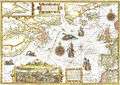 Nova Francia .. Terra Nova 1592
 Insulae Moluccae 1592
References
- ↑ "New and exact geographic and hydrographic map of the world".
- ↑ Leo Bagrow, History of Cartography, revised and enlarged by R. A. Skelton, London, Watts, 1964, p.265. Exacta & accurata delinatio cum orarum maritimarum tum etiam locorum terrestrium quæ in regionibus China, Cauchinchina, Camboja, sive Champa, Syao, Malacca, Arracan & Pegu ; Cornelis Koeman, Jan Huygen Van Linschoten, Coimbra, Universidade de Coimbra Biblioteca Geral 1, 1984, Centro de Estudos de Historia e Cartografia, Vol.153, pp.39-41. Also in Revista da Universidade de Coimbra, vol.32, 1985, pp.27-47.
- ↑ "On Frederick de Houtman's catalogue of southern stars, and the origin of the southern constellations", by E. B. Knobel, 1917, the catalogue starting at page 421
- 1 2 "Star Tales ― CHAPTER ONE continued..." by Ian Ridpath
- ↑ Dekker, Elly (1987). "Early Explorations of the Southern Celestial Sky". Annals of Science. 44: 439–470.
- 1 2 3 Le costellazioni di Petrus Plancius, on Atlas Coelestis by Felice Stoppa
- ↑ Astronomical naming conventions#Names and boundaries of constellations
External links
| Wikimedia Commons has media related to Petrus Plancius. |
- Star Tales – the constellations of Petrus Plancius
- Minor planet 10648 Plancius