Petershagen
For the municipality of Brandenburg, see Petershagen-Eggersdorf.
| Petershagen | ||
|---|---|---|
| ||
 Petershagen | ||
Location of Petershagen within Minden-Lübbecke district 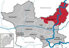
 | ||
| Coordinates: 52°23′N 8°58′E / 52.383°N 8.967°ECoordinates: 52°23′N 8°58′E / 52.383°N 8.967°E | ||
| Country | Germany | |
| State | North Rhine-Westphalia | |
| Admin. region | Detmold | |
| District | Minden-Lübbecke | |
| Government | ||
| • Mayor | Dieter Blume (CDU) | |
| Area | ||
| • Total | 212 km2 (82 sq mi) | |
| Population (2015-12-31)[1] | ||
| • Total | 25,663 | |
| • Density | 120/km2 (310/sq mi) | |
| Time zone | CET/CEST (UTC+1/+2) | |
| Postal codes | 32469 | |
| Dialling codes | 05707 | |
| Vehicle registration | MI | |
| Website | www.petershagen.de | |

Petershagen (Northern Low Saxon: Päitershaugen) is a town in the Minden-Lübbecke district, in North Rhine-Westphalia, Germany. It lies on the Westphalian Mill Route.
Geography
Petershagen is situated on the river Weser, approx. 10 km north-east of Minden.
Neighbouring municipalities
Division of the town
The town of Petershagen consists of 29 districts:
|
|
|
International relations
Main article: List of twin towns and sister cities in Germany
Petershagen is twinned with:
-
 Petershagen-Eggersdorf (Brandenburg, Germany) -- since 1990
References
- ↑ "Amtliche Bevölkerungszahlen". Landesbetrieb Information und Technik NRW (in German). 18 July 2016.
External links
- Official site (German)
- Virtual tour through the city Petershagen (German)
Towns and municipalities in Minden-Lübbecke | ||
|---|---|---|
This article is issued from Wikipedia - version of the 11/27/2016. The text is available under the Creative Commons Attribution/Share Alike but additional terms may apply for the media files.