Peterhead
| Peterhead | |
| Scottish Gaelic: Ceann Phàdraig[1] | |
| Scots: Peterheid, The Blue Toun | |
 |
|
 Peterhead |
|
| Population | 18,537 (2011)[2] |
|---|---|
| OS grid reference | NK135465 |
| Council area | Aberdeenshire |
| Lieutenancy area | Aberdeenshire |
| Country | Scotland |
| Sovereign state | United Kingdom |
| Post town | Peterhead |
| Postcode district | AB42 |
| Dialling code | 01779 |
| Police | Scottish |
| Fire | Scottish |
| Ambulance | Scottish |
| EU Parliament | Scotland |
| UK Parliament | Banff and Buchan |
| Scottish Parliament | Banffshire and Buchan Coast |
Coordinates: 57°30′33″N 1°47′00″W / 57.5091°N 1.7832°W
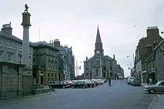
Peterhead (![]() listen ; Scottish Gaelic: Ceann Phàdraig,[3] Scots: Peterheid
listen ; Scottish Gaelic: Ceann Phàdraig,[3] Scots: Peterheid ![]() listen )[4] is a town in Aberdeenshire, Scotland. It is Aberdeenshire's biggest settlement (the city of Aberdeen itself not being a part of the district), with a population of 18,537 at the 2011 Census.[2]
listen )[4] is a town in Aberdeenshire, Scotland. It is Aberdeenshire's biggest settlement (the city of Aberdeen itself not being a part of the district), with a population of 18,537 at the 2011 Census.[2]
Peterhead sits at the easternmost point in mainland Scotland. It is often referred to as The Blue Toun (locally spelt as "The Bloo Toon") and people who were born there as Blue Touners (locally spelt as "Bloo Tooners"). More correctly they are called blue mogginers (locally spelt as "Bloomogganners"), supposedly from the blue worsted moggins or stockings that the fishermen originally wore.
History
Peterhead was founded by fishermen and was developed as a planned settlement. In 1593 the construction of Peterhead's first harbour, Port Henry, encouraged the growth of Peterhead as a fishing port and established a base for trade.
Peterhead was a Jacobite supporting town in the Jacobite risings of 1715 and 1745. In particular, it was one of the Episcopalian north-eastern ports where reinforcements, plus money and equipment, were periodically landed from France during the Forty-Five.[5]
A lifeboat station was first established in 1865.[6] Since early times Peterhead has received a portion of its water supply from Morris Wells.[7] Peterhead convict prison was opened in 1888, gaining a reputation as one of Scotland's toughest prisons.
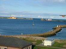
The present harbour has two massive breakwaters, enclosing an area of approximately 300 acres in Peterhead bay. The south breakwater, about 2700 ft long, was constructed in 1892–1912 using convict labour from the prison. The north breakwater, constructed 1912–56, is approximately 1500 ft long.[8]
A new phase of growth was initiated in the 1970s with Peterhead becoming a major oil industry service centre, and the completion of the nearby St Fergus gas terminal. At this time, considerable land holdings were allocated for industrial development.
In recent times, the town has suffered from several high-profile company closures and is facing a number of pressures, including Common Fisheries Policy reforms. However, it retains a relatively diverse economy, including food processing, textiles, service industries and, still importantly, fishing. (Over 90,000 tonnes of fish, with a value of around £60m are now landed at Peterhead, which is still also base to over 550 fishermen.) The Peterhead Port Authority plans to extend the northern breakwater as a stimulus to the town's economic development. In addition, to assist with business diversification and town centre environmental improvements, the 'Peterhead Project' initiative under the Aberdeenshire Towns Partnership brings together the Council, Scottish Enterprise Grampian, Communities Scotland, commerce and community representatives.
Until April 2005, the Royal Air Force station RAF Buchan was located near the town.
Local government
Peterhead is the largest settlement in Buchan, a committee area of Aberdeenshire.
The town was a burgh in the historic county of Aberdeenshire. In 1930 it became a small burgh under the Local Government (Scotland) Act 1929, but in 1975 small burghs were abolished and Peterhead became part of the district of Banff and Buchan within the new Grampian Region. When districts and regions were abolished in 1996, Peterhead became part of the new unitary authority of Aberdeenshire.
Since 1975 Peterhead has had a community council, with limited powers.
Education
Peterhead Academy
Peterhead Academy houses around 1,300 pupils and the school is split into six houses (Arbuthnot, Buchan, Craigewan, Grange, Marischal and Slains), with all the names associated with areas of the town. The school has pupils coming from surrounding villages such as Boddam, Cruden Bay, Hatton, Inverugie, Rora, St Fergus and Crimond. The academy's motto is "Domus Super Petram Aedificata" (A House Built on a Rock). The academy is Scotland's largest school at over 22,920 square metres (246,700 sq ft) of gross internal floor area. The school has multiple subjects such as ICT, English, French/German, Technical, Engineering, Art, Home Economics, and many more.[9]
Primary and specialist schools
Peterhead has six primary schools (Clerkhill, Buchanhaven, Meethill, Dales Park, Central, Burnhaven).
There is one special school, Anna Ritchie, which caters for most specific learning difficulties, autism and other disabilities.
There is also Peterhead Alpha School which caters for children with social, emotional, and behavioural difficulties, as well as learning difficulties, e.g. dyspraxia and dyslexia.
Transport
Peterhead has a number of in-town and out-of-town bus services.[10]
Peterhead is further from a railway station (32 miles from Aberdeen) than any other town of its size in Britain. The town once had two stations Peterhead railway station and Peterhead Docks railway station. Passenger trains stopped in 1965, and freight in 1970. The start of reconstruction of the Borders line to Galashiels (early 2013) has begun a local political debate into the possibility of reopening the line from Aberdeen to Fraserburgh and Peterhead.
The nearest airport with scheduled services is Aberdeen Airport. A heliport has been set up at the Eastern end of the former RAF Buchan air base. Recreational aviation also takes place from a part of a former runway.[11]
Blueprint for Growth
In 2008, a Blueprint for Growth was published – a plan to extend the town beyond its bypass. The plan involved 4500 homes, 4 new primary schools, a new secondary school and a new hospital to be built in the next 20–25 years – hoping to bring 9000 people to the town.
Tourism
The harbours, maritime and built heritage are the town's principal tourism assets. Recent initiatives include investments in the Peterhead Bay area, which have included the berthing of cruise ships in the harbour. A number of projects are planned under the auspices of the Peterhead Project initiative, including tourism strategy development, enhancement of existing attractions, measures to improve the town's physical attractiveness, and improved marketing and promotion.
Sport
Peterhead F.C. are a Scottish Football League club who play in the League One. They won the League Two championship in 2013–14.
Peterhead also has a successful amateur boxing club, and in 2008 was the most successful boxing club in Northern Scotland. And currently has two reigning Scottish champions. The boxing gym is open to all and located in Ellis Street.
Peterhead RFC are a Scottish Rugby Union team who play at the Lord Catto playing fields.
Maritime Economy
Peterhead has a thriving port, serving the fishing, oil and gas and other commercial industries. It also receives many visiting seafarers arriving on ships that ply these trades. Seafarers' welfare organisation Apostleship of the Sea has a port chaplain at Peterhead to provide pastoral and practical support to them.
Twin town
- Ålesund, Norway
Notable natives
- William Aitken, Scottish League footballer
- Eric Temple Bell, mathematician and science fiction author
- Peter Buchan, editor
- Stevenson Buchan FRSE FGS (1907-1996) geologist
- Charles Creighton, physician and medical author
- William Gibson, politician
- Alexander Hall, Scottish League footballer
- Arthur D. Hay, judge
- William Hay, architect
- Margaret Jope, biochemist
- George Keith, missionary
- James Francis Edward Keith, soldier
- Marino Keith, Scottish League footballer
- William Keith, colonial governor of Pennsylvania
- George Kynoch, engineering businessesman
- Jim Lovie, footballer
- Jamie McLeary, golfer
- Stuart MacLeod, magician who frequently performs in local primary schools
- Gilbert Mair, sailor and merchant trader
- Frederick Martin, politician
- Peter Mullan, actor and film maker
- James Niven, physician
- James Wales, artist
- Stephen Calder, local historian
- Estelle Maskame, author
The town is also mentioned in Jules Verne's science-fiction novel 'A Journey to the Centre of the Earth' (1864).
See also
- List of Provosts of Peterhead
- Clerkhill
- Buchanhaven – Village within Peterhead
- Peterhead power station
- Scotland-Norway interconnector
- Waves Radio
- Whaling in Scotland
References
- ↑ Ainmean-Àite na h-Alba ~ Gaelic Place-names of Scotland
- 1 2 "Area Profiles". Scotland's Census 2011. Retrieved 30 December 2013.
- ↑ According to Iain Mac an Tàilleir's list of placenames, "The name Ceann Phàdraig ["Peter's headland"] is a fairly recent translation from English. The town was known as Inbhir Ùigidh, "mouth of the Ugie" or Inverugie, in the eastern Gaelic speaking areas."
- ↑ "Scotslanguage.com - Names in Scots - Places in Scotland".
- ↑ C. Duffy, The 45 (2003), p. 352
- ↑ Brief History of Peterhead Lifeboat Station www.peterheadlifeboat.co.uk, accessed 15 July 2008
- ↑ C. Michael Hogan. 2008. Catto Long Barrow fieldnotes, The Modern Antiquarian
- ↑ R. Paxton and J. Shipway, (2007) Civil Engineering heritage: Scotland – Highlands and Islands, London: Thomas Telford Ltd. Sample Chapter
- ↑ http://www.scotland.gov.uk/Topics/Statistics/Browse/School-Education/schestate2011
- ↑ "Peterhead Town Services Map" (PDF).
- ↑ "Buchan Aero Club Longside Airfield - Peterhead".
External links
| Wikivoyage has a travel guide for Peterhead. |
![]() Media related to Peterhead at Wikimedia Commons
Media related to Peterhead at Wikimedia Commons
- Peterhead Scottish Week – Annual gala in town
- Local Authority Covering Peterhead Area
- Waves Radio – Local Radio station for Peterhead & Surrounding areas
- Peterhead RFC Official Website
- Peterhead Lifeboat Station
Settlements and places of interest in Buchan, Aberdeenshire | ||
|---|---|---|
| Primary settlements | 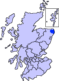 | |
| Other settlements | ||
| Places of interest | ||
Areas and primary settlements in Aberdeenshire (see also: Aberdeen City) | ||
|---|---|---|
| in Banff and Buchan | 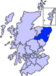 | |
| in Buchan | ||
| in Formartine | ||
| in Garioch | ||
| in Kincardine and Mearns | ||
| in Marr | ||