Petaling Jaya
| Petaling Jaya ڤتاليڠ جاي | |||
|---|---|---|---|
| City | |||
 | |||
| |||
| Nickname(s): PJ, Bandar Raya Inai Merah | |||
|
Motto: Mesra, Cepat, Tepat (English: Friendly, Expedient, Precise) | |||
 Location within Petaling District and the state of Selangor | |||
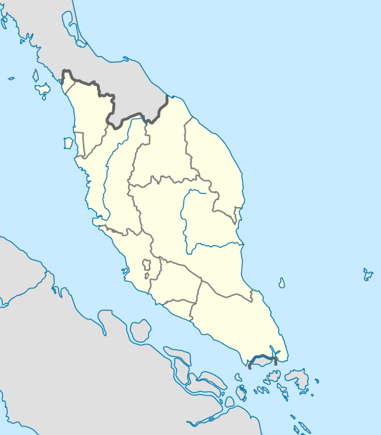 Petaling Jaya Location in Peninsular Malaysia | |||
| Coordinates: 3°05′N 101°39′E / 3.083°N 101.650°E | |||
| Country | Malaysia | ||
| State | Selangor | ||
| Establishment | 1954 | ||
| Granted city status | 2006, 20 June | ||
| Government | |||
| • Mayor | Mohd Azizi Mohd Zain | ||
| Area | |||
| • Total | 97.2 km2 (37.5 sq mi) | ||
| Population (2010 ) | |||
| • Total | 638,516 | ||
| • Density | 6,600/km2 (17,000/sq mi) | ||
| Time zone | MST (UTC+8) | ||
| • Summer (DST) | Not observed (UTC) | ||
| Website |
www | ||


Petaling Jaya (Commonly called "PJ" by locals) is a major Malaysian city originally developed as a satellite township for Kuala Lumpur. It is located in the Petaling District of Selangor with an area of approximately 97.2 square kilometres (37.5 sq mi). Petaling Jaya was granted city status on 20 June 2006.
Petaling Jaya is surrounded by the Malaysian capital, Kuala Lumpur to the east, Sungai Buloh to the north, the capital of Selangor, Shah Alam to the west and Subang Jaya to the south.
History
The city was developed during British Malaya on a piece of 1,200 acres (486 ha) rubber estate (the Effingham Estate) around Old Klang Road to address the overpopulation of the capital Kuala Lumpur in the 1950s.[1] Since 1952, PJ witnessed a dramatic growth in terms of population size and geographical importance. The development of Petaling Jaya commenced in 1952 with the construction of 800 houses centred on the area known as “Old Town” today.
Lieutenant-General Sir Gerald Templer (then the British High Commissioner of Malaya and Petaling District council chairman) planned for Petaling Jaya to be a satellite town to prevent people from assisting the communists; the earlier housing areas were fenced off from the surrounding area. The first two main roads built in Petaling Jaya were simply called "Jalan 1" or Road 1 and "Jalan 2" or Road 2. Road 1 was later named Jalan Templer while Road 2 was named Jalan Othman after Othman Mohamad, former Menteri Besar (Chief Minister) of Selangor.
Until the end of 1953, the town was administered by the Kuala Lumpur district officer. The Petaling Jaya Town Authority headed by N.A.J. Kennedy commenced administrating Petaling Jaya in 1954. On 24 August 1959, Encik Abdul Aziz bin Haji Mohd Ali became the first Malayan to head the PJ Authority. Administratively and historically, it was considered part of Kuala Lumpur. However, Petaling Jaya ceased to be part of Kuala Lumpur when the latter became a Federal Territory on 1 February 1974. It then became a township in its own right within the state of Selangor.
PJ South (also known as PJS), from Section 8 to PJ Old Town, had the first settlements, which were established around 1953. As development progressed, PJ North, on the other side of the Federal Highway was developed. The first shopping complex in Petaling Jaya was Jaya Shopping Centre (better known as Jaya Supermarket), located in Section 14, which was built in 1974.
On 1 January 1977, the Petaling Jaya Town Authority was upgraded to become Petaling Jaya Municipal Council or Majlis Perbandaran Petaling Jaya (MPPJ). Petaling Jaya progressed rapidly due to the massive rural-urban migration. As more people from rural areas immigrated, Sungai Way and Subang districts along with areas such as Subang Jaya, Seksyen 52 (New Town or colloquially known as "State", the name of the first, former cinema in the area) developed in areas under the jurisdiction of the municipality.
In a boundary realignment exercise in early 1997, parts of Petaling Jaya including Subang Jaya, USJ, Putra Heights, and Bandar Sunway were placed under the jurisdiction of the newly formed Subang Jaya Municipal Council or MPSJ. Petaling Jaya is the central hub of Klang Valley as it is located in between Kuala Lumpur and surrounding suburbs.
Due to the proximity of the city to the capital of Malaysia, Petaling Jaya had and have been the headquarters of many federal government departments such as Jabatan Pendaftaran Negara (National Registration Department, 1958-2004),[2] Jabatan Arkib Negara Malaysia (Malaysian National Archive Department, 1961-1982)[3] and Jabatan Kimia Malaysia (Malaysian Chemistry Department, 1957-).[4]
Climate
Petaling Jaya is one of the wettest cities in Malaysia. It is warm with an average maximum of 30 degrees Celsius and receives heavy rainfall all year round, roughly more than 3,300 mm (130 in) of average rainfall annually. The city has no particular true dry season, but June and July are the driest months. Mostly each month average rainfall receives more than 200 mm (7.9 in). Thunderstorms and extreme rainstorms are common, and it is one of the highest lightning strike areas in the world. But due to global warming, Petaling Jaya is experiencing severe drought with frequent water rationing among neighbourhoods.
| Climate data for Petaling Jaya | |||||||||||||
|---|---|---|---|---|---|---|---|---|---|---|---|---|---|
| Month | Jan | Feb | Mar | Apr | May | Jun | Jul | Aug | Sep | Oct | Nov | Dec | Year |
| Average high °C (°F) | 32.5 (90.5) |
33.3 (91.9) |
33.5 (92.3) |
33.5 (92.3) |
33.4 (92.1) |
33.1 (91.6) |
32.6 (90.7) |
32.7 (90.9) |
32.5 (90.5) |
32.5 (90.5) |
32.1 (89.8) |
31.9 (89.4) |
32.8 (91) |
| Average low °C (°F) | 23.1 (73.6) |
23.5 (74.3) |
23.8 (74.8) |
24.2 (75.6) |
24.4 (75.9) |
24.2 (75.6) |
23.7 (74.7) |
23.7 (74.7) |
23.7 (74.7) |
23.7 (74.7) |
23.6 (74.5) |
23.4 (74.1) |
23.8 (74.8) |
| Average rainfall mm (inches) | 189.8 (7.472) |
210.1 (8.272) |
273.5 (10.768) |
298.9 (11.768) |
243.1 (9.571) |
128.7 (5.067) |
141.1 (5.555) |
168.9 (6.65) |
198.1 (7.799) |
280.1 (11.028) |
330.3 (13.004) |
261.2 (10.283) |
2,723.8 (107.236) |
| Average rainy days (≥ 1.0 mm) | 11 | 12 | 16 | 16 | 14 | 9 | 10 | 11 | 13 | 17 | 18 | 15 | 162 |
| Source: World Meteorological Organisation[5] | |||||||||||||
Governance

On 20 June 2006, Petaling Jaya was granted a city status and Dato' Ahmad Termizi Puteh, a former Yang di-Pertua MPPJ, automatically became the first mayor (Datuk Bandar) of Petaling Jaya. Petaling Jaya's local council changed its name to Majlis Bandaraya Petaling Jaya (MBPJ) or Petaling Jaya City Council following the granting of city status. On 15 August, Dato' Ahmad Termizi Puteh retired from the post of mayor.[6] He was later replaced by Dato' Hj. Mohamad Roslan Sakiman.
The residents of Petaling Jaya are served by four Members of Parliament, DAP's Tony Pua in PJ Utara, PKR's Hee Loy Sian in PJ Selatan, PKR's R. Sivarasa in Subang and PKR's Wong Chen in Kelana Jaya.
City sections

Petaling Jaya is divided into several sections. Some are subdivided into smaller neighbourhoods (kejiranan), for example SS5D. Some sections have their own names (SS1 as Kampung Tunku), while other sections are grouped together (SS3, SS4, SS5, SS6 and SS7 as part of Kelana Jaya). Besides that, Petaling Jaya also comprises the affluent township of Damansara.
Demographics
As of 2014, Petaling Jaya claimed 613,977 residents living in the area of 51.4 square kilometres (19.8 square miles). The actual population by 2015 would have been a little over 550,000 residents without taking into account the total population of the Kuala Lumpur-Petaling Jaya conurbation which would have resulted in a total population of 1.5 million.
Landmarks
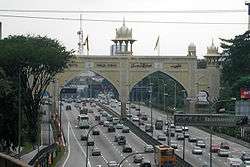
A prominent landmark in PJ is the Kota Darul Ehsan arch which symbolically marks the boundary between Kuala Lumpur and Petaling Jaya. This arch straddled the Federal Highway (Lebuhraya Persekutuan) which was originally the only highway link between Petaling Jaya and Kuala Lumpur. However, many links now exist as alternatives to the congested Federal Highway.
Close to the Kelana Jaya Line's Taman Jaya Station are the Petaling Jaya Museum Thai Wat Chetawan temple. This ornate building is very popular amongst the Buddhist community. A short drive ahead is PJ State, the nickname for the Central Business District of Petaling Jaya with the landmark Menara MBPJ as a focal point. PJ State is more formally referred to as PJ New Town.
Damansara is the main shopping hub of Petaling Jaya with many of the city's shopping malls being located there. Some of the notable shopping malls in the city include The Curve, Ikea, Ikano Power Centre (IPC), One Utama, Tropicana City Mall, Empire Damansara, Sunway Pyramid and Paradigm Mall.
Economy

The 1980s saw the establishment of shopping malls like The Atria in Damansara Jaya and Subang Parade in the nearby suburb or satellite town of Subang Jaya. The Atria provided the opportunity for residents to patronise either the Japanese Kimisawa or the French Printemps department stores, as well as a Burger King restaurant.
In 1995, 1 Utama commenced operations at Bandar Utama. Jaya Jusco, a Japanese department store which had operated since 1984 at Taman Tun Dr Ismail later relocated as one of the anchor tenants of 1 Utama.
Tesco supermarket commenced operations in Mutiara Damansara in 2003. This was quickly followed by the Ikano Power Centre in 2004 and The Curve in 2005. The Ikano Power Centre (now renamed as IPC Shopping Centre in 2011) houses Southeast Asia's largest IKEA Swedish furniture store. At about the same time, the 1 Utama new wing had commenced operations.

In 2004, Giant Hypermarket commenced operations in Kelana Jaya. This complex houses the Giant Hypermarket and some shops to create a more shopping centre style. It is easily accessed off the Damansara-Puchong Expressway. Nearby is the SStwo Mall, which was opened at the end of December 2010, and Paradigm Mall, which opened in mid-2012.
Properties in Petaling Jaya
Active property developers in Petaling Jaya are PKNS, (which are the main pioneer of development for PJ), Sunway Bhd, Tropicana Bhd, AmCorp, Mah Sing Group and Guocoland as well as many others. Due to the size of Petaling Jaya township, properties development in the area also includes small to medium-sized developers such as Sri Aman Development and Nusmetro.
Before the rapid development and commercialisation of Petaling Jaya, there were only a handful of residential developments which comprises mostly low to medium-cost apartments as well as terrace houses. By 2005, luxurious condominiums, semi detached houses and bungalows are a common sight within the area. These high end properties are mostly located at Bukit Gasing, Section 16 & 17, SS7 Kelana Jaya, and more recent ones such as Tropicana, and Ara Damansara.
Transport
Transportation facilities and infrastructure are well developed in Petaling Jaya. Bus services were initially provided by Sri Jaya between the early 1950s until the early 1990s. Some SEA Park residents may recall the old Sri Jaya Leyland Albion buses on the No. 241 service struggling to climb the relatively steep Jalan 21/1.
The introduction of the IntraKota bus system by DRB-Hicom saw the replacement of Sri Jaya and the mini-buses by the early 1990s. At the same time, some of the Petaling Jaya-Kuala Lumpur bus routes were serviced by Metrobus.
The introduction of the Putra LRT service in 1998 saw the addition of the Putraline feeder bus services. The combination of Putraline and Putra LRT brought a relief to many Petaling Jaya residents especially those who had to rely on public transportation.
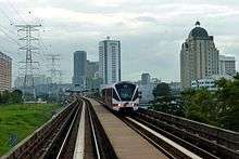
In 2006 RapidKL took over the operations of IntraKota, Star, and Putra LRT. Today, public transportation is provided by RapidKL in the form of buses as well as the KL Light Rail Transit System - Kelana Jaya Line, which extends slightly into Petaling Jaya. There are five Kelana Jaya Line stations in Petaling Jaya.
Petaling Jaya has three access points to the national highway system: North-South Expressway via Kota Damansara, Damansara, and Subang. Internally, highways such as the Damansara-Puchong Expressway, Sprint Expressway and the Federal Highway exist.
Currently, new public transportation infrastructure is being constructed in the form of the Sungai Buloh-Kajang Line, the first MRT line in the Klang Valley as part of the Klang Valley Mass Rapid Transit Project. Ten of the Thirty-one stations will be located within Petaling Jaya. The extension of the Kelana Jaya Line towards Subang Jaya and Putra Heights and the planned Bandar Utama-Klang Line also serves to increase public transportation infrastructure in Petaling Jaya.
Education
There are more than 25 colleges and universities in Petaling Jaya including Malaysia's oldest and most esteemed university, University of Malaya, National Institute of Ophthalmic Science - The Academic Arm of The Tun Hussein Onn National Eye Hospital in Lorong Utara B Petaling Jaya, International Islamic University Malaysia (IIUM/UIAM) centre for foundation studies campus in Section 17, MARA University of Technology (UiTM) campus branch on Jalan Othman in Section 1, Universiti Tunku Abdul Rahman (UTAR) Petaling Jaya Campus in Section 13 (The campus have moved to Sungai Long), Tun Abdul Razak University (UNITAR) main campus in SS6 Kelana Jaya, Stamford College on Jalan Timur and Jalan 223 (moved out, no longer there), Food Institute of Malaysia (FIM) in SS6 Kelana Jaya, Malaysia University of Science & Technology (MUST) main campus in SS7, KDU University College (KDU) in Damansara Jaya, Kolej Bandar Utama (KBU) in Bandar Utama, IACT College at Damansara Utama and International University College Of Technology Twintech a private college at Bandar Sri Damansara.
The UiTM facility in Section 1 commenced life as the Dewan Latehan RIDA in November 1956. It was later renamed the Dewan Latihan MARA. This was a training centre under the auspices of RIDA or the Rural and Industrial Development Authority. Essentially it was also the inspiration of Dato' Onn Jaafar, the founder and former president of UMNO or the United Malays National Organisation. This UiTM facility can be regarded as Petaling Jaya's oldest college.
There are many secondary schools in Petaling Jaya including Sekolah Menengah Kebangsaan Taman SEA, SMK Damansara Utama, Bukit Bintang Boys School, SMK Assunta, Sri Aman Girls School, Catholic High School, La Salle PJ, SMK Damansara Jaya, SMK Sultan Abdul Samad, SMK Taman Medan, SMK (P) Taman Petaling and SMK Kelana Jaya. The oldest school in Petaling Jaya is likely the Road 10 Primary School in Old Town. The foundation stone of the school was placed by Sultan Hisamuddin Alam Shah in 1952.
The German School Kuala Lumpur, a German international school, is in Petaling Jaya.[7]
Malaysia's first private nursing college is at Assunta Hospital in Petaling Jaya. The Tun Tan Cheng Lock College of Nursing was founded in 1961.
Places of worship

The Muslim community can pray at mosques such as those at Jalan Templer, Section 17, Section 14, Section SS1 and Damansara Utama. Masjid Kelana Jaya Putera, which was built in the late-2000s, is located in Kelana Jaya. Masjid Jamek Sultan Abdul Aziz Shah at Jalan Templer is likely the oldest mosque in Petaling Jaya. This mosque was declared open by HRH the Sultan of Selangor on 23 October 1964. Later in 2008, the mosque was modernised and rebuilt.
The Roman Catholic Christian community can attend mass at churches such as the St Francis Xavier which was established in 1961. It is located at Jalan Gasing, Assumption on Jalan Templer as well as at St Ignatius in Taman Mayang. The Assumption church is the oldest: It dates from 15 August 1959.[8] The Trinity Methodist church dates from 2 August 1959 and is at Jalan 5/37. An Anglican as well as a Lutheran church is located at Jalan Utara. Glad Tidings Assembly of God church is at Jalan Bersatu 13/4. Several shophouse-based churches exist across Petaling Jaya. In 2005, the former Ruby Cinema in SEA Park temporarily became the Damansara Utama Methodist Church. Harvest Community Church (an Assembly of God church) is located at D-1-36, 8 Avenue Business Centre, Jalan Sungai Jernih 8/1, 46050, Petaling Jaya. Small "shoplot" churches can be found all around the city; some of these transform into larger churches, like Grace Assembly PJ (an assembly of god church). These attract a larger following and can be found in many places around the city.
The Thai Chetawan Temple along Jalan Gasing and at the Cempaka Buddhist Lodge in SS23 Taman SEA. Chinese temples such as Poh Lum Fatt Yuen along Jalan Gasing fulfil the needs of the Taoist community. Taoist temples can be found in PJ Old Town and in Section 11.
The Sri Sithi Vinayagar Temple (Sanskrit: श्री सिद्धि)at Section 4 along Jalan Selangor serves as the main religious facility for Petaling Jaya's Hindu community. The main God worshiped here is Ganesh, (Sanskrit: गणेश). Vinayaga is a common name for Ganesh. There is a Mariamman Temple in Jalan 17/47, and the Geeta Ashram is a north-Indian style Hindu Temple dedicated to Krishna. The Geeta Ashram can be found in Lorong Utara B in Section 52.
There is a Sikh Gurdwara located in Lorong Utara B, beside the Tun Hussein Onn Eye Hospital and the Geeta Ashram.
Notable people
- Riad Asmat, former CEO of Caterham F1 Team in 2010-2014 was born on 17 November 1971.
- Bernard Chandran, Malaysian fashion designers
International relations
Sister cities
Petaling Jaya currently has four sister cities:
References
- PJ set to undergo major redevelopment, The Star, 4 May 2007.
- One of PJ’s earliest supermarkets, The Star, 7 May 2007.
| Wikimedia Commons has media related to Petaling Jaya. |
- ↑ "Executive Summary". Majlis Bandaraya Petaling Jaya (MBPJ). Retrieved 2 December 2015.
- ↑ "National Registration Department". Retrieved 21 Aug 2015.
- ↑ "Arkib Negara Malaysia". Retrieved 21 Aug 2015.
- ↑ "Jabatan Kimia Malaysia". Retrieved 21 Aug 2015.
- ↑ "World Weather Information Service — Petaling Jaya". World Meteorological Organisation. Retrieved 7 May 2014.
- ↑ "Archives | The Star Online". Thestar.com.my. 17 August 2006. Retrieved 9 December 2013.
- ↑ "Impressum." German School Kuala Lumpur. Retrieved on 17 January 2015. "Anschrift: Deutsche Schule Kuala Lumpur Lot 5, Lorong Utara B 46200 Petaling Jaya"
- ↑ "." Assumption Church. Retrieved on 24 October 2009.
- 1 2 3 4 "Sister City Programme". Sustainable Petaling Jaya 2030. Archived from the original on 21 December 2015. Retrieved 21 December 2015.
- 1 2 3 "Pencapaian Sepanjang 2012 (Program Sister City)" (in Malay). Department of Development Planning, MBPJ. 24 October 2012. Archived from the original on 21 December 2015. Retrieved 21 December 2015.
External links
| Wikivoyage has a travel guide for Petaling Jaya. |
 |
Sungai Buloh | | ||
| Shah Alam | |
Kuala Lumpur | ||
| ||||
| | ||||
| Subang Jaya |
Coordinates: 3°05′N 101°39′E / 3.083°N 101.650°E