Permanent System radar stations
| Permanent System | |
| Military radar network | |
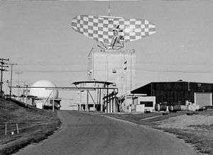 Buildings at Fortuna Air Force Station (P-27) included the tower for the general surveillance Sperry AN/FPS-35 radar (top) and a different radar with radome (left). In front of the FPS-35 tower is a pedestal for a previous radar. | |
| Countries | United States, Canada |
|---|---|
| Command | Air Defense |
| Radar Stations on December 31, 1957 |
75 primary 47 gap-filler 39 semi-mobile 19 Pinetree 1 Texas Tower 1 with Lashup radar |
| Networks 1980 December 23 | |
The Permanent System ("P system") was a 1950s radar network ("P radar net") used for the CONUS "manual air defense system"[1] and which had a USAF aircraft control and warning (AC&W) organization of personnel and military installations with radars to allow Air Defense Command ground-controlled interception of Cold War bombers attacking the United States.
Planning
As with the World War II CONUS radar network of "Army Radar Stations", Aircraft Warning Corps information centers, Ground Observer Corps filter centers, and Fighter Control Centers ("inactivated...in April 1944"),[2]:38 a post-war system was planned to assess bomber attacks and for dispatching interceptors. The Distant Early Warning Line was "first conceived—and rejected—in 1946",[2]:2 General Stratemeyer forwarded an air defense plan to General Spaatz in November 1946,[3]:62 and in the spring and summer of 1947, 3 Air Defense Command (ADC) Aircraft Control and Warning (AC&W) plans had gone unfunded:[4]:53 e.g., the April 8, 1947, "air defense plan (long term)".[3]:62 With only 5 "Air Warning Station" radars operating in 1948,[5] the "Radar Fence Plan (code named Project SUPREMACY)" was planned for completion by 1953 with 411 radar stations and 18 control centers. The Radar Fence was rejected by ADC since "no provision was made in it for the Alaska to Greenland net with flanks guarded by aircraft and picket ships [required] for 3 to 6 hours of warning time".[2]:129 ADC's Interim Program and its First Augmentation were planned "until the Supremacy plan network could be approved and constructed",[4]:54 and an $85,500,000 March 1949 Congressional bill funded both the Interim Program "for 61 basic radars and 10 control centers to be deployed in 26 months, with an additional ten radars and one control station for Alaska" and the augmentation's additional 15 radars ("essentially Phase II of Supremacy").[4]:54 The resulting Lashup Radar Network was completed in April 1950 and was operational in June 1950.
On February 13, 1950, HQ USAF had "advanced the completion date from July 1, 1951, to December 31, 1950, for the most essential radar stations.[6] The USAF reallocated $50 million for the "permanent Modified Plan" (modified from Supremacy) to "start construction on the high Priority Permanent System of radars in February 1950 with the first 24 radar sites to be constructed by the end of 1950".[4]:61 Early June 1950 exercises "in the 58th Air Division [tbd Lashup sites] indicated insufficient low-altitude coverage," and the Secretary of the Air Force requested a 2nd stage of 28 stations on July 11, 1950 (Secretary of Defense approval was on July 21.) By November 1950, Ground Observation Corps filter centers (7 in the west, 19 in the east) were being installed.[7] By November 10 a separate Air Defense Command headquarters was approved,[7]:140 the Federal Civil Defense Administration was created in December 1950,[4]:59 and command centers communicated radar track information to the national ADC center that had moved from Mitchell Field to Ent Air Force Base on 8 January 1951.[8]
Description
The "original construction program for the Permanent System" was completed in May 1952,[4]:61 USAF AC&W squadrons were established (renamed Radar Squadrons in the mid-1950s), and the Ground Observation Corps was expanded in 1952 (Operation Skywatch) with over 750,000 volunteers at over 16 thousand posts (98 per post in shifts) and 75 centers.
| Air Division | # Coordinates |
AFB, etc. DC |
ST | Years |
|---|---|---|---|---|
| n/a | [command center at HQ ADC/NORAD/CONAC] | Ent | CO | 1951-63 |
| MCC-01 | ||||
| 29th | MCC-02 | Richards-Gebaur DC-08 |
MO | 1957-69 |
| MCC-03 | ||||
| 28th | MCC-06 | Hamilton | CA | |
| MCC-07 | ||||
| (Oklahoma City) | MCC-11 | Oklahoma City AFS | OK | |
| MCC-16 | ||||
| MCC-17 |
Manual Air Defense Control Centers
Manual Air Defense Control Centers (ADCC, MCC) of the Permanent System were USAF command posts for command, control, and coordination by Air Defense Command, including early Cold War ground-controlled interception of enemy aircraft. Each MCC networked radar stations of the sector, plotted radar tracks & visual observations, and forwarded information to ADC command center at Mitchel Field, Ent Air Force Base in 1951, and the new 1954 Ent blockhouse subsequently used by the 1954 CONAD and the 1957 NORAD. MCCs were generally located at or near a radar station, e.g., Andrews Air Force Base MCC in Maryland (at/near radar station SM-171), Dobbins AFB GA (M-87), Geiger Field WA (SM-172), Kirtland AFB NM (P-41), Norton AFB CA (P-84), Oklahoma City AFS OK (P-52), Roslyn AFS NY (P-3), Snelling AFS MN (P-36), Willow Run AFS MI (P-23), and Wright-Patterson AFB OH (SM-170).
Some MCCs were replaced by Direction Centers of the subsequent SAGE Radar Network, e.g., when McGuire DC-01 was established, the Roslyn Air Force Station MCC became the "Combat Alert Center (Manual)". MCCs continued at several sites where DCs were planned but never built for sectors at Albuquerque, Fort Knox, Kansas City, Miami, Raleigh, San Antonio, Shreveport, and St Louis.
- Filter Centers
- Filter Centers of the Ground Observation Corps (e.g., in New Haven, Connecticut and Baltimore, Maryland).[9] processed reports from ~8,000 CONUS watch posts. As with ranger stations for forest fires, watch posts measured the azimuth of a target aircraft or formation, and Filter Centers triangulated azimuth observations from 2 or more stations, assessed the reliability of observations, and provided visual track information to MCCs.
Radar stations
Five radar stations of the Lashup Radar Network were redesignated as Permanent System stations (3 later upgraded with newer radars developed for the Permanent System): Montauk L-10/LP-45/P-45, Fort Custis L-15/LP-56, Palermo L-13/LP-54/P-54, Sault Sainte Marie L-17/LP-20, and Highlands L-12/LP-9/P-9. From March to November 1951, the "LP" designation was also used for 23 new stations for the Permanent System that were outfitted, instead of with radars developed for the Permanent System, with older radars such as the January 1945 General Electric AN/CPS-5 radar, 1948 Western Electric AN/TPS-1B Radar, and Bendix AN/TPS-1C radar. The LP designator was also used for 1 station opened with AN/FPS-3 and AN/FPS-5 radars in 1950 (Tierra Amarilla LP-8). More than 15 of the new LP stations were subsequently upgraded and designated P-xx stations, and some of the squadrons at LP stations that closed moved to new P stations. Permanent System radars were developed in various programs such as the AN/FPS-6 (in program MX-1353 - "Long range S-band height finder") and AN/MPS-10 (MX-1354 - "Mobile long range search radar set").[10]
- Priority Permanent System
- The "Priority Permanent System" with the initial (priority) radar stations having new radar systems included "ADC radar site" P-1 at McChord AFB on June 1, 1950. Completed in May 1952 to replace the 1950 Lashup Radar Network,[4]:61 the Priority Permanent System had 5 redesignated LASHUP stations, 23 new stations in 1951 with older radars, 62 stations in 1951 with new equipment, and several of the 10 newly equipped 1952 stations (including Manassas RP-55). The Priority Permanent System used Manual ADCCs, e.g., with Plexiglas plotting boards as at the 1954 Ent Air Force Base command center for ADC.[7]:151
- P system extension
- The "first extension of the P system into Canada" (“Canadian extensions”) for the Pinetree Line[2]:134 was planned by the "Radar Extension Program" for 33 stations and was agreed by the US and Canada in November 1950. The plan "was submitted to the Permanent Joint Board on Defense on February 6, 1951, and" was subsequently approved by both nations,[7]:159 but by "April 1951 the United States still had not contributed to the Radar Extension Program".[7]:160 On June 13, 1951, the US released $20 million for the stations and by June 1952, the joint Canadian-American committee on the Radar Extension Program was replaced with the "Project Pinetree Office" in Ottawa, Ontario.[7]:160
- Gap-filler and semi-mobile radar stations
- On January 18, 1952, ADC proposed the construction of small, unmanned stations with gap filler radars.[2]:227 The USAF Directorate of Plans (War Plans Division) “prepared the proposal … to add 29 mobile and 135 low-altitude stations to ADC's radar system” for completion by the end of 1955.[7]:187 The first phase began with three 1953 stations at Walker M-90, Ellsworth M-97, and Houma M-126 (Z-126); and was completed with 1957 stations at Almaden M-96 (Z-96), Mount Hebo M-100, Jacksonville M-114 (Z-114), and Cherry Point M-116.
The "second-phase mobile radar program" was requested by the ADC commander in October 1952[7] and was completed from 1954 starting with Geiger Field SM-172 through 1962 with Hastings SM-133 (Z-133). The Planning Guide for the Third Phase Augmentation Radar Program' was issued April 5, 1954, and the 3rd phase was for 29 stations, many for coverage along the U.S.-Mexican border and the Gulf of Mexico (the Air Force Council had agreed with ADC’s request for the third phase on October 28, 1953.)[7] The "resulting 104 stations were all to be operational by 1956",[7]:154 and a mock 1956 attack blinded ground defense radars.[11] The third phase of 29 stations[2]:137 was deployed beginning with 5 1957 stations and ended with the 1960 Sundance TM-201 (Z-201). Gap-filler annexes of Mather P-58 (P-58A at Modesto & P-58B at Oroville) were some of the Permanent System stations planned, but never built.
Texas Towers were approved on January 11, 1954,[2] and despite 11 Permanent System radar stations closing in 1957 (N-28 Pinetree station and the M-87, M-101, M-104, M-105, M-106, M-109, M-122, M-128, M-131, & SM-137 stations), at "the end of 1957, ADC operated 182 radar stations…32 had been added during the last half of the year as low-altitude, unmanned gap-filler radars. The total consisted of 47 gap-filler stations, 75 Permanent System radars, 39 semimobile radars, 19 Pinetree stations,…1 Lashup[-era radar and a] single Texas Tower".[7]:223
- Relocated stations
- When radar stations began converting to SAGE, 8 Permanent stations that closed from 1959-1964 had their squadrons relocated to stations with "RP" designations, including the radar squadrons from the last 2 remaining "LP" stations: (Elkhorn/Williams Bay LP-31 and Blue Knob/Claysburg LP-63). All but 1 of the relocating squadrons went to new sites (the 770th moved to a 1955 Army radar station designated USAF RP-54 in 1961), and 5 of the units co-located with Project Nike Missile Master units. A 1959-1961 USAF radar squadron was at the Fort Heath radar station of the joint-use site system (JUSS).
Replacement
Groundbreaking for the SAGE System facilities began in 1957,[12] Ground Observer Corps operations ended in 1958,[13] and most Permanent System radar stations were modified to have an AN/FST-2 computer to provide the automated environment (cf. Mather AFB which relayed data through Mill Valley AFS). On "June 26, 1958,…the New York sector became operational" with the SAGE Direction Center at McGuire AFB (DC-01),[7]:207 and in 1959, ADC's Air Divisions and the AC&W Squadrons were redesignated, e.g., the 27th Air Division was renamed between February 1, 1959, and April 1, 1966, as the Los Angeles Air Defense Sector (LAADS); and the 609th AC&W Sq became the "614th Radar Squadron (SAGE)" on September 1, 1959. Permanent System stations not included in the SAGE network were phased out beginning with 9 in 1957; then the first closure for SAGE of a 1951 station (Roslyn P-3) was in 1958.
The radar stations were redesignated with NORAD identification numbers Z-2, etc. on July 31, 1963. The SAGE centers were subsequently replaced with the full operational capability of 7 Joint Surveillance System centers on December 23, 1980,[14] and remaining radar stations of the permanent network include the former 1951 P-37, P-38, and RP-39 which became FAA Ground Equipment Facility radar stations of the Joint Surveillance System.
References
- ↑ In Your Defense (digitized movie). Morton, Colonel John (narrator). Western Electric. Retrieved 2012-04-03.
- 1 2 3 4 5 6 7 History of Strategic and Ballistic Missile Defense, 1945-1955: Volume I (PDF).
Stations were undermanned, personnel lacked training, and repair and maintenance were difficult. This stop-gap system later would be replaced by a 75-station, permanent net authorized by Congress and approved by the President in 1949 … To be closer to ConAC, ARAACOM moved to Mitchel AFB, New York on 1 November 1950.
- 1 2 "Chapter 3: Planning for Air Defense in the Postwar Era". Emerging Shield. pp. 47–81 (pdf pp. 62–96).
- 1 2 3 4 5 6 7 "Chapter II: American Strategy for Air and Ballistic Missile Defense". History of Strategic Air and Ballistic Missile Defense, 1945–1955: Volume I. pp. 37–68.
- ↑ Montauk AFS History. Radomes.org. Retrieved on 2013-09-18.
- ↑ Vinson, Carl (February 13, 1950), title tbd (letter), available on microfilm at USAFHRC (cited by Schaffel p. 120)
- 1 2 3 4 5 6 7 8 9 10 11 12 Schaffel, Kenneth (1991). Emerging Shield: The Air Force and the Evolution of Continental Air Defense 1945-1960 (45MB pdf). General Histories (Report). Office of Air Force History. ISBN 0-912799-60-9. Retrieved 2011-09-26.
- ↑ compiled by Johnson, Mildred W (31 December 1980) [February 1973 original by Cornett, Lloyd H. Jr]. A Handbook of Aerospace Defense Organization 1946 - 1980 (PDF). Peterson Air Force Base: Office of History, Aerospace Defense Center. p. . Retrieved 2012-03-26.
- ↑ "Less Than Half Spotter Time Filled In Week" (Google News Archive). The Gettysburg Times. Times and News Publishing Company. April 5, 1954. Retrieved 2012-01-04.
- ↑ MX-1000 to MX-1499 Listing. Designation-systems.net (2005-11-20). Retrieved on 2013-09-18.
- ↑ Winkler, David F; Webster, Julie L (June 1997). Searching the Skies: The Legacy of the United States Cold War Defense Radar Program (PDF) (Report). U.S. Army Construction Engineering Research Laboratories. LCCN 97020912. Retrieved 2012-03-26.
"BUIC II radar sites would be capable of incorporating data feeds from other radar sectors directly onto their radar screens.
- ↑ "title tbd". GlobalSecurity.org.
- ↑ https://news.google.com/newspapers?id=VukVAAAAIBAJ&sjid=dBAEAAAAIBAJ&pg=1611,526065&dq=filter-center&hl=en
- ↑ Del Papa, Dr. E. Michael; Warner, Mary P. (October 1987). A Historical Chronology of the Electronic Systems Division 1947-1986 (PDF) (Report). Retrieved 2012-07-19.
so-called Semi-Automatic Direction Center System, later known as…Semi-Automatic Ground Environment System, in essence, the Lincoln Transition System.