Pennsylvania Route 532
| ||||
|---|---|---|---|---|
 | ||||
| Route information | ||||
| Maintained by PennDOT | ||||
| Length: | 19.125 mi[1] (30.779 km) | |||
| Major junctions | ||||
| South end: |
| |||
|
| ||||
| North end: |
| |||
| Location | ||||
| Counties: | Philadelphia, Bucks | |||
| Highway system | ||||
| ||||

Pennsylvania Route 532 (PA 532) is a 19.1-mile-long (30.7 km) state route located in the Philadelphia, Pennsylvania area. The route runs from an intersection with U.S. Route 1 (US 1) in Northeast Philadelphia north to an intersection with PA 32 in Washington Crossing near the Washington Crossing Bridge over the Delaware River. The route passes through developed areas in Northeast Philadelphia before heading north through suburban Bucks County, serving Feasterville, Holland, and Newtown before coming to Washington Crossing.
Most of the portion of PA 532 south of Feasterville was chartered as the Somerton and Bustleton Turnpike in 1840. This road in Philadelphia became known as Bustleton Avenue in 1903. PA 532 was designated in 1928 to run from US 1 in Northeast Philadelphia to PA 32 in Yardley while PA 632 was designated on the route between Newtown and Washington Crossing. By 1947, PA 532 was rerouted to Washington Crossing, replacing PA 632, while the road between Newtown and Yardley became an extension of PA 332. The Newtown Bypass was built in 1977 and PA 532 was routed onto it in 1991.
Route description
Philadelphia

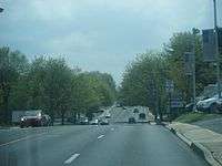
PA 532 begins at an intersection with US 1 (Roosevelt Boulevard) in Philadelphia, heading north-northwest on two-lane undivided Welsh Road. The road heads through Northeast Philadelphia, passing through residential areas before running past businesses. The route turns northeast onto Bustleton Avenue, a four-lane undivided road with some segments having a center left-turn lane. PA 532 continues through areas of homes and businesses in the Bustleton neighborhood, curving north and coming to a bridge over CSX's Trenton Subdivision. The road runs past more houses, businesses and apartments, crossing PA 63. The route continues through more developed areas and heads northeast into the Somerton neighborhood. PA 532 crosses Byberry Road and continues north, coming to a bridge over SEPTA's West Trenton Line near the Somerton station. The route crosses Philmont Avenue and curves northeast, reaching an intersection with County Line Road.[2][3]
Bucks County
Crossing County Line Road, PA 532 enters Bucks County in Lower Southampton Township, where the name of the road changes to Bustleton Pike. The route continues north as a five-lane road with a center left-turn lane, passing through suburban business areas with nearby residential areas. The road comes to a bridge over the Pennsylvania Turnpike (I-276) and comes to an intersection with PA 132 in Feasterville. Past this intersection, PA 532 passes more commercial establishments and splits from Bustleton Pike by turning northeast onto four-lane undivided Bridgetown Pike. A short distance later, PA 532 turns north onto two-lane undivided Buck Road, with PA 213 continuing along Bridgetown Pike. PA 532 curves northeast and passes through wooded residential areas. The road enters Northampton Township and passes under Norfolk Southern's Morrisville Line before passing businesses in the community of Holland. At an intersection with Old Bristol Road, the route curves to the north before turning northeast at an intersection with Holland Road. PA 532 passes through areas of wooded residential subdivisions, passing to the east of Council Rock's Holland Middle School. The road passes under the abandoned Fox Chase/Newtown railroad line before heading into the community of Village Shires, where it passes to the west of the Village Shires Shopping Center. After passing through Village Shires, the route crosses the Neshaminy Creek and enters Newtown Township. Here, PA 532 widens into a four-lane road and passes more residential subdivisions before coming to an intersection with PA 332/PA 413.[2][4]
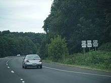
At this point PA 532, turns northwest and joins PA 332 and PA 413 on the four-lane divided Newtown Bypass, with Sycamore Street continuing northeast into Newtown. The bypass turns north and passes through wooded areas with nearby residential development. PA 332 splits from the Newtown Bypass by heading west on Richboro Road while PA 413 and PA 532 continue to the north on the bypass. The roadway passes to the east of Tyler State Park, curving to the northwest. At the entrance to the park, PA 413/PA 532 turn northeast to remain on the Newtown Bypass while Swamp Road heads to the northwest. The road passes between a residential development to the northwest and a shopping center to the southeast before the Newtown Bypass ends at an intersection with Durham Road, at which point PA 413 heads north on Durham Road and PA 532 heads east on Durham Road. The route narrows to a two-lane undivided road and comes to another intersection with Sycamore Street.[2][4]

At this point, PA 532 turns north and runs along Washington Crossing Road, passing through a mix of woods and residential neighborhoods and curving to the northeast. The route heads into a mix of fields and woodland with some residences, crossing into Lower Makefield Township. At the Stoopville Road intersection, PA 532 turns east and runs along the border between Upper Makefield Township to the north and Lower Makefield Township, passing to the south of Washington Crossing National Cemetery. The route fully enters Upper Makefield Township and turns north at the Dolington Road intersection in the community of Dolington. The road curves northeast and runs through more areas of farms and woods with occasional homes. PA 532 heads into Washington Crossing and crosses Taylorsville Road, at which point the name changes to General Washington Memorial Boulevard. The road crosses the Delaware Canal and runs past homes and businesses. PA 532 reaches its northern terminus at an intersection with PA 32. Past this intersection, the road continues over the Delaware River on the Washington Crossing Bridge into New Jersey, where it intersects Route 29 on the other side of the river and becomes County Route 546 past that intersection.[2][4]
History
| |
|---|---|
| Location: | Newtown – Washington Crossing |
| Existed: | 1928–1947 |
The Bustleton and Somerton Turnpike, a turnpike, was incorporated on April 14, 1840, running through present-day Northeast Philadelphia.[5] In 1872, the Bustleton and Somerton Turnpike was combined with the Richborough and Feasterville Turnpike Road to form one continuous turnpike.[6] The city of Philadelphia approved renaming the Bustleton and Somerton Turnpike within the city to Bustleton Avenue in 1903.[7] When Pennsylvania legislated its state highways in 1911, what would become PA 532 was legislated as part of Legislative Route 252 between Newtown and Yardley.[8] In 1928, PA 532 was designated to run from US 1 in Northeast Philadelphia north to PA 32 in Yardley, following its current alignment to Newtown, where it turned east and ran to Yardley. The portion of the current route between Newtown and Washington Crossing was designated as PA 632.[9][10]
PA 532 was rerouted to its current alignment between Newtown and Washington Crossing by 1947, replacing PA 632. The former alignment of PA 532 between Newtown and Yardley became an extended PA 332.[11][12] In 1977, the Newtown Bypass to the west of Newtown was built as part of a bypass of the town for PA 413; PA 532 still continued through Newtown at this time.[13][14] PA 532 was rerouted to bypass Newtown along with PA 332 in 1991.[15][16] The former alignment of PA 532 through Newtown followed Sycamore Street.[15]
Major intersections
| County | Location | mi[1] | km | Destinations | Notes |
|---|---|---|---|---|---|
| Philadelphia | Philadelphia | 0.000 | 0.000 | ||
| 2.113 | 3.401 | ||||
| Bucks | Lower Southampton Township | 5.762 | 9.273 | ||
| 6.074 | 9.775 | Southern terminus of PA 213 | |||
| Newtown Township | 11.519 | 18.538 | Southern terminus of concurrency | ||
| 12.102 | 19.476 | Northern terminus of concurrency | |||
| 12.973 | 20.878 | Northern terminus of concurrency | |||
| Upper Makefield Township | 19.125 | 30.779 | |||
1.000 mi = 1.609 km; 1.000 km = 0.621 mi
| |||||
PA 532 Alternate Truck
| |
|---|---|
| Location: | Bucks County |
| Existed: | 2013–present |
Pennsylvania Route 532 Alternate Truck is a truck route bypassing a weight-restricted bridge over the Delaware Canal in Upper Makefield Township, on which trucks over 29 tons and combination loads over 35 tons are prohibited. Formed in 2013, it follows Taylorsville Road and PA 32.[17][18]
See also
 U.S. Roads portal
 Pennsylvania portal
 Philadelphia portal
References
- 1 2 Bureau of Maintenance and Operations (January 2015). Roadway Management System Straight Line Diagrams (Report) (2015 ed.). Pennsylvania Department of Transportation. Retrieved June 30, 2015.
- Philadelphia County (PDF)
- Bucks County (PDF)
- 1 2 3 4 Google (January 4, 2014). "overview of Pennsylvania Route 532" (Map). Google Maps. Google. Retrieved January 4, 2014.
- ↑ Metro Philadelphia, Pennsylvania (Map) (19th ed.). 1"=2000'. ADC Map. 2006. ISBN 978-0-87530-777-0.
- 1 2 3 Bucks County, Pennsylvania (Map) (19th ed.). 1"=2000'. ADC Map. 2006. ISBN 0-87530-774-4.
- ↑ Pennsylvania County Court Reports. 35. T & J.W. Johnson Company. 1909. p. 520. Retrieved January 4, 2014.
- ↑ Laws of the General Assembly of the Commonwealth of Pennsylvania. Commonwealth of Pennsylvania. 1872. p. 649. Retrieved January 4, 2014.
- ↑ Ordinances and Opinions of the City Solicitor. Dunlap Printing Company. 1904. p. 220. Retrieved January 4, 2014.
- ↑ Map of Pennsylvania Showing State Highways (PDF) (Map). Pennsylvania Department of Highways. 1911. Retrieved January 1, 2014.
- ↑ Map of Pennsylvania (Map). Pennsylvania Department of Highways. 1928. Retrieved May 7, 2015.
- ↑ Tourist Map of Pennsylvania (PDF) (Map). Pennsylvania Department of Highways. 1930. Retrieved January 1, 2014.
- ↑ Newark, NJ 1:250,000 Quadrangle (Map). United States Department of the Army. 1947. Retrieved October 9, 2009.
- ↑ Official Road Map of Pennsylvania (PDF) (Map). Pennsylvania Department of Highways. 1950. Retrieved January 1, 2014.
- ↑ Gagnier, Mary (September 10, 1989). "At Long Last Start Of Bypass Extension Is Marked". The Philadelphia Inquirer. Retrieved January 4, 2012.
- ↑ Pennsylvania Official Transportation Map (PDF) (Map). Pennsylvania Department of Highways. 1980. Retrieved January 1, 2014.
- 1 2 Bucks County Pennsylvania (PDF) (Map). Pennsylvania Department of Transportation. 1991. Retrieved January 4, 2012.
- ↑ Bishop, Todd (June 11, 1997). "Newtown Traffic Solution 2 First Was The Bypass, Now So Busy, Drivers Are Leaving It. The Sequel: New Traffic Light Timers.". The Philadelphia Inquirer. Retrieved January 4, 2012.
- ↑ Google (January 20, 2016). "overview of Pennsylvania Route 532 Alternate Truck" (Map). Google Maps. Google. Retrieved January 20, 2016.
- ↑ "Risk-Based Bridge Postings - State and Local Bridges" (PDF). Pennsylvania Department of Transportation. October 8, 2013. Retrieved January 20, 2016.
External links
| Wikimedia Commons has media related to Pennsylvania Route 532. |