Pennsylvania Route 88
| ||||
|---|---|---|---|---|
 | ||||
| Route information | ||||
| Maintained by PennDOT | ||||
| Length: | 67.8 mi[1] (109.1 km) | |||
| Major junctions | ||||
| South end: |
| |||
|
| ||||
| North end: |
| |||
| Location | ||||
| Counties: | Fayette, Greene, Washington, Allegheny | |||
| Highway system | ||||
| ||||

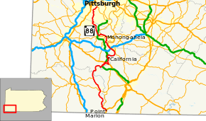
Pennsylvania Route 88 (PA 88) is a 68-mile-long (109 km) north–south state highway located in southwestern Pennsylvania. The southern terminus of the route is at U.S. Route 119 in Point Marion less than 2 miles (3 km) from the Pennsylvania-West Virginia border. The northern terminus is at Pennsylvania Route 51 in Pittsburgh. PA 88 runs parallel to the Monongahela River for almost its entire length.
Signed in 1927, PA 88 is one of the oldest state highways in Pennsylvania. For a brief period between 1927 and 1928, the route followed the Perry Highway between Pittsburgh and Erie. In 1928, the Perry Highway became U.S. Route 19.
Route description
Fayette County
PA 88 begins in Point Marion at an intersection with U.S. Route 119. PA 88 begins as Main Street then turns to the west crossing the Monongahela River into Greene County.
Greene County
After crossing the Monongahela River, PA 88 has entered Greene County and PA 88 turns to the north as it begins to parallel the Monongahela River to the east as well as railroad tracks to the west. After crossing the Dunkard Creek, PA 88 has entered the village of Poland Mines. In Monongahela Township, PA 88 intersects Pennsylvania Route 21. In the boro of Carmichaels, PA 88 is called Vine Street and crosses the Muddy Creek. In Jefferson Township, PA 88 intersects the eastern terminus of Pennsylvania Route 188 southwest of Rices Landing.
Washington County
After crossing the Tenmile Creek, PA 88 has entered Washington County as Front Street. PA 88 passes through the following villages: Milfred Terrace, Fredericktown Hill, North Fredericktown, Vesta Heights, and Vestaburg. In East Bethlehem Township and Centerville Boro. In Centerville Boro, PA 88 becomes Low Hill Rd. PA 88 has a snake like curve paralleling the Monongahela River. In Centerville Boro, PA 88 joins Pennsylvania Turnpike 43 for 2 miles (3.2 km) before leaving to join another concurrency with U.S. Route 40. East of PA 43, PA 88 leaves US 40 at a trumpet interchange in West Brownsville. North of the concurrency, PA 88 becomes a local road named California Road. In California, PA 88 becomes Wood Street then turns to the west and becomes 3rd Street. In Coal Center, PA 88 Highpoint Drive, then Spring Street, and then Highpoint Drive again. Passengers can see Turnpike 43 from PA 88 in Coal Center. As PA 88 begins to shift to the east, it enters the following boros: Elco, Roscoe, and Stockdale. As PA 88 enters these boros it becomes Highpoint Drive and Chester Avenue. North of Stockdale, PA 88 begins to turn to the north and becomes Main Street. In Speers as Pennsylvania Street, PA 88 interchanges Interstate 70 at exit 40 in a scaped shaped interchange with long ramps. In Charleroi and North Charleroi, PA 88 is called McKean Avenue. In Carroll Township, PA 88 is called Country Club Road and meets the southern terminus of Pennsylvania Route 837. In Monongahela, PA 88 begins a three route concurrency with Pennsylvania Route 136 and Pennsylvania Route 837. Then PA 88/PA 136/PA 837 become Main Street and intersect the northern terminus of Pennsylvania Route 481. In the northern tip of Monongahela, PA 136 splits off from PA 88 and PA 837. As PA 88/PA 837 enter New Eagle, PA 837 splits from PA 88 then PA 88 becomes Union Street. In Nottingham Township, PA 88 passes over Turnpike 43. In Finleyville, PA 88 becomes Sheridan Avenue. Finleyville is where the future Interstate 576 (Southern Beltway) will meet Turnpike 43. North of Finleyville, PA 88 is called Finleyville Thomas Road.
Allegheny County
The entire 8.5 mile Allegheny County stretch of PA 88 is also designated as Library Road. Starting at the Washington/Allegheny County line where Finleyville Thomas Rd. becomes Library Rd., PA 88 runs through South Park, Bethel Park, Castle Shannon, and the Overbrook neighborhood of Pittsburgh where PA 88/Library Rd. ends at an "Y" intersection with Pennsylvania Route 51/Saw Mill Run Blvd. Three of the six county's colored Belt Routes connect with and/or run along PA 88 (see below).
History
At one point, the route went north of Pittsburgh all the way to New Castle. The Pittsburgh-to-New Castle section was largely split off on July 15, 1960 to form Pennsylvania Route 65, in honor of the 65th Infantry Division of the United States Army during World War II. The 7.7 mile stretch of PA 88 from PA 65's current southern terminus at the West End Bridge to PA 88's current northern terminus was decommissioned. This designation change was made to reduce the number of concurrent routes in Pittsburgh. The changes took effect a few months later and signs were changed by spring 1961.[2]
Nonetheless, PA 88's legacy still survives in its former northern section. Four of PA 88's five spur routes (PA 288, PA 388, PA 488, & PA 588) are now spur routes of 65, but still retain the "88" base numbers. (PA 88 did retain PA 188 as a spur route.) In addition, a drive-in theater known as Spotlight 88 in North Sewickley Township retained its name after the route was rebadged as 65, and is still known by that name as its current incarnation as a flea market after the drive-in was destroyed by an F3 tornado on May 31, 1985.[3][4]
Major intersections
| County | Location | mi[1] | km | Destinations | Notes |
|---|---|---|---|---|---|
| Fayette | Point Marion | 0.0 | 0.0 | Southern terminus of PA 88 | |
| Monongahela River | Point Marion Bridge | ||||
| Greene | Monongahela Township | 10.9 | 17.5 | ||
| Jefferson Township | 17.5 | 28.2 | Eastern terminus of PA 188 | ||
| Washington | Centerville | Interchange, southern terminus of Toll PA 43 concurrency | |||
| 29.2 | 47.0 | Interchange, northern terminus of Toll PA 43 concurrency, southern terminus of US 40 concurrency | |||
| West Brownsville | 30.5 | 49.1 | Interchange, northern terminus of US 40 concurrency | ||
| California | 33.2 | 53.4 | Southern terminus of Truck PA 88 | ||
| 33.9 | 54.6 | Northern terminus of Truck PA 88 | |||
| Speers | 42.2 | 67.9 | Exit 40 (I-70) | ||
| Carroll Township | 46.7 | 75.2 | Southern terminus of PA 837 | ||
| Monongahela | 48.6 | 78.2 | Southern terminus of PA 136/PA 837 concurrency | ||
| 48.8 | 78.5 | Northern terminus of PA 481 | |||
| 49.9 | 80.3 | Northern terminus of PA 136 concurrency | |||
| New Eagle | 51.0 | 82.1 | Northern terminus of PA 837 concurrency | ||
| Allegheny | Bethel Park | 61.3 | 98.7 | Southwestern terminus of Orange Belt | |
| 65.2 | 104.9 | Southern terminus of Yellow Belt concurrency | |||
| Castle Shannon | 66.2 | 106.5 | Northern terminus of Yellow Belt concurrency | ||
| Pittsburgh | 68.4 | 110.1 | Southern terminus of Blue Belt concurrency | ||
| 67.8 | 109.1 | Northern terminus of PA 88 and its concurrency with the Blue Belt | |||
1.000 mi = 1.609 km; 1.000 km = 0.621 mi
| |||||
PA 88 Truck
| |
|---|---|
| Location: | California, Pennsylvania |
Pennsylvania Route 88 Truck is a 2-mile-long (3.2 km) truck route in California, Pennsylvania. The route was created to allow access to the Pennsylvania Route 43 toll freeway and to allow large vehicles to avoid the large hill into the Monongahela Valley. The center of the route is at the PA 43 interchange, with a two-lane stretch providing access to California University of Pennsylvania and the surrounding business district, as well as connecting traffic with northbound Route 88; a four-lane stretch provides a more gradual ascent of the hill on Route 88 southbound.
See also
 U.S. Roads portal
 Pennsylvania portal
 Pittsburgh portal
References
- 1 2 DeLorme Street Atlas USA 2007
- ↑ "Designations Of Highways Are Changed". The Evening Standard. Uniontown, PA. July 16, 1960. p. 7. Retrieved August 28, 2015 – via Newspapers.com.

- ↑ Pennsylvania Highways - Pennsylvania Route 88
- ↑ "65 Infantry Division - Pennsylvania Route 65". Retrieved 2007-03-13.