Pennsylvania Route 796
| ||||
|---|---|---|---|---|
 | ||||
| Route information | ||||
| Maintained by PennDOT | ||||
| Length: | 5.784 mi[1] (9.308 km) | |||
| Major junctions | ||||
| South end: |
| |||
|
| ||||
| North end: |
| |||
| Highway system | ||||
| ||||

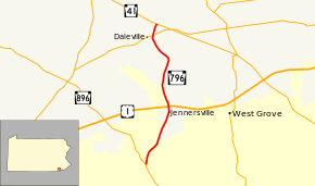
Pennsylvania Route 796 (PA 796) is a state highway in Chester County, Pennsylvania. The route runs 5.8 miles (9.3 km) from PA 896 in New London Township north to PA 41 in Londonderry Township. PA 796 heads through rural areas with some development along its route. In Jennersville, the route crosses Baltimore Pike and has an interchange with the U.S. Route 1 (US 1) freeway. PA 796 crosses PA 926 a short distance south of its northern terminus. PA 796 was originally designated by 1930 between the Maryland border near Kemblesville and north of Jennersville. During the 1930s, the southern terminus was moved to its current location, with PA 896 replacing the route south to the Maryland border, while the northern end was extended to PA 926. PA 796 was extended north to PA 41 in the 1940s.
Route description
PA 796 begins at an intersection with PA 896 in New London Township, Chester County, heading north on two-lane undivided Jennersville Road. The route soon crosses into Penn Township and curves northeast through a mix of fields and woods with some development. In the residential community of Kelton, PA 796 comes to a bridge over an East Penn Railroad line. The road continues north and passes residential neighborhoods and commercial establishments along with some farms. PA 796 reaches the community of Jennersville, where it crosses Baltimore Pike. A short distance later, the route comes to an interchange with the US 1 freeway. Following this, the road heads north through agricultural areas with some woods and homes. PA 796 crosses into Londonderry Township and curves northwest. The route curves north again and crosses PA 926. PA 796 continues to its northern terminus at PA 41, where the road continues as unnumbered Derry Meeting Road.[2][3]
History
When Pennsylvania first legislated routes in 1911, present-day PA 796 was not legislated as part of any route.[4] By 1928, the current route of PA 796 was paved between the southern terminus and north of Jennersville; at this time it did not carry a route number.[5] By 1930, PA 796 was designated to run from the Maryland border southeast of Kemblesville north to a point north of Jennersville, heading through Kemblesville and New London before picking up its current alignment.[6] During the 1930s, the southern terminus was cut back to its current location, with an extended PA 896 replacing the route south of that point, while the northern terminus was extended to PA 926 along a newly-paved road.[7] The route was extended north to PA 41 along a paved road during the 1940s.[8] By 1970, the interchange with the US 1 freeway was built, with the route having previously intersected US 1 at the Baltimore Pike intersection.[9][10]
Major intersections
The entire route is in Chester County.
| Location | mi[1] | km | Destinations | Notes | |
|---|---|---|---|---|---|
| New London Township | 0.000 | 0.000 | |||
| Penn Township | 2.366 | 3.808 | Interchange | ||
| Londonderry Township | 5.335 | 8.586 | |||
| 5.784 | 9.308 | ||||
| 1.000 mi = 1.609 km; 1.000 km = 0.621 mi | |||||
See also
 U.S. Roads portal
 Pennsylvania portal
References
- 1 2 Bureau of Maintenance and Operations (January 2015). Roadway Management System Straight Line Diagrams (Report) (2015 ed.). Pennsylvania Department of Transportation. Retrieved June 30, 2015.
- Chester County (PDF)
- ↑ Google (December 17, 2014). "overview of Pennsylvania Route 796" (Map). Google Maps. Google. Retrieved December 17, 2014.
- ↑ Chester County, Pennsylvania (Map) (17th ed.). 1"=2000'. ADC Map. 2006. ISBN 0-87530-778-7.
- ↑ Map of Pennsylvania Showing State Highways (PDF) (Map). Pennsylvania Department of Highways. 1911. Retrieved December 14, 2014.
- ↑ Pennsylvania Highway Map (Philadelphia Metro) (Map). Gulf Oil. 1928. Retrieved November 8, 2007.
- ↑ Tourist Map of Pennsylvania (PDF) (Map). Pennsylvania Department of Highways. 1930. Retrieved December 16, 2014.
- ↑ Official Road Map of Pennsylvania (PDF) (Map). Pennsylvania Department of Highways. 1940. Retrieved December 16, 2014.
- ↑ Official Road Map of Pennsylvania (PDF) (Map). Pennsylvania Department of Highways. 1950. Retrieved January 1, 2014.
- ↑ Official Map of Pennsylvania (PDF) (Map). Pennsylvania Department of Highways. 1960. Retrieved December 17, 2014.
- ↑ Official Map of Pennsylvania (PDF) (Map). Pennsylvania Department of Highways. 1970. Retrieved December 17, 2014.