Pennsylvania Route 380
| |||||||
|---|---|---|---|---|---|---|---|
 | |||||||
| Route information | |||||||
| Maintained by PennDOT | |||||||
| Length: | 32.80 mi[1] (52.79 km) | ||||||
| Existed: | 1928 – present | ||||||
| Major junctions | |||||||
| West end: |
| ||||||
| East end: |
| ||||||
| Location | |||||||
| Counties: | Allegheny, Westmoreland | ||||||
| Highway system | |||||||
| |||||||

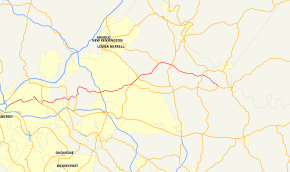
Pennsylvania Route 380 (officially, SR 400 because of I-380 elsewhere in Pennsylvania[2]), also known as J.F. Bonetto Memorial Highway and within the city of Pittsburgh Bigelow Boulevard, Baum Boulevard and Frankstown Road, is a 32.80 mi (52.8 km) long state highway in western portions of the U.S. state of Pennsylvania. The western terminus of the route is at Interstate 579 in downtown Pittsburgh near PPG Paints Arena.[3] The eastern terminus is at Pennsylvania Route 286 in Bell Township, near the hamlet of Wakena.
When it was first assigned in the late 1920s, PA 380 occupied only the portion of its modern alignment between PA 286 in Murrysville and PA 286 west of Saltsburg. It was later extended westward over the former routing of PA 80 to Pittsburgh.
Route description
Allegheny County
PA 380 begins along the ramps of the Bigelow Boulevard and Interstate 579 interchange in Downtown Pittsburgh, north of the former Civic Arena complex. The route proceeds east traversing Ammon Playground park in the Hill District. PA 380 also parallels the Norfolk Southern railroad and the Martin Luther King, Jr. East Busway on this section of the four-lane Bigelow Boulevard. In the neighborhood of Polish Hill, PA 380 intersects the Bloomfield Bridge via eastbound ramp and westbound at-grade intersection; the bridge connects to Liberty Avenue and the Bloomfield neighborhood.[4]
In the Upper Hill section of the city, PA 380 turns east becoming Baum Boulevard. In East Liberty, the route splits into one-way pairs around a large traffic circle known as Penn Circle. PA 380 exits the circle onto Penn Avenue running southeast into the Larimer neighborhood. In Point Breeze, PA 380 overlaps PA 8 for two blocks, from Fifth Avenue to Dallas Avenue; PA 380 turns north onto Dallas Avenue while PA 8 continues on Penn Avenue. In the Homewood South area, PA 380 turns east onto Bennett Street. A few miles east, the route becomes Frankstown Road in East Hills, the easternmost neighborhood in the city Pittsburgh. Frankstown Road leads 380 out of the city and into the eastern suburban area.[5]
In the Penn Hills hamlet of Laketon Heights, the route intersects PA 130. In the hamlet of Rodi, PA 380 meets the northern terminus of PA 791 and begins an overlap with the Yellow Belt. Both routes take a more northern alignment into the northeastern portions of the township. Near the Alcoma Golf Club, PA 380 leaves the Yellow Belt, while turning east onto Saltsburg Road. Roughly east of the Pennsylvania Turnpike overpass in the borough of Plum, PA 380 begins an overlap with the Orange Belt at the intersection with Center Road near Boyce Park. At the New Texas Road junction, the belt turns north and leaves PA 380.[6]
Westmoreland County
As PA 380 enters Westmoreland County, the highway interchanges PA 286. PA 380 then proceeds on a northeast course along the Golden Mile Highway, a multi-lane divided highway with access ramps. Near Rolling Fields Golf Club, PA 380 interchanges PA 366. Past the interchange, the highway continues on its northeast alignment. In the Westmoreland Business Research Park area, PA 380 intersects the eastern terminus of PA 780. The route proceeds eastward to interchange PA 66 in the hamlet of North Washington. East of 66, PA 380 winds its way along the northern banks of the Beaver Run Reservoir and terminates at PA 286, a few miles west of Saltsburg.[7]
History
In the late 1920s and early 1930s, PA 380 was first designated from Pennsylvania Route 80 in Murrysville to the current eastern terminus. From U.S. Route 22 and U.S. Route 30 at the intersection of Dallas and Penn Avenues in Pittsburgh to Murrysville near the Allegheny-Westmoreland County line, PA 380 was signed as PA 80.[8][9]
By 1940, PA 80 was extended west onto Bigelow Boulevard, Baum Boulevard, and Penn Avenue in Pittsburgh, modern designations of PA 380.[10] By 1960, PA 380 replaced most of PA 80 from Dallas and Penn Avenues in Pittsburgh to Murrysville.[11] On July 15, 1960, PA 380 replaced all of PA 80 from Interstate 479 (now I-579) to Dallas and Penn Avenues. This designation change was made to reduce the number of concurrent routes in Pittsburgh. The changes took effect a few months later and signs were changed by spring 1961.[12][13] The reason for doing this was because Interstate 80 was created, so PA 80 was removed so there would not be two Route 80s.
Major intersections
| County | Location | mi[1] | km | Destinations | Notes |
|---|---|---|---|---|---|
| Allegheny | Pittsburgh | 0.00 | 0.00 | 6th Avenue – Consol Energy Center | Interchange, Western terminus of PA 380 |
| 5.01 | 8.06 | Western terminus of PA 8 concurrency | |||
| 5.32 | 8.56 | Eastern terminus of PA 8 concurrency | |||
| Penn Hills | 8.02 | 12.91 | |||
| 9.52 | 15.32 | ||||
| 10.72 | 17.25 | Northern terminus of PA 791, southern terminus of Yellow Belt concurrency | |||
| 12.22 | 19.67 | Northern terminus of Yellow Belt concurrency | |||
| Plum | 15.82 | 25.46 | Western terminus of Orange Belt concurrency | ||
| 17.22 | 27.71 | Eastern terminus of Orange Belt concurrency | |||
| Westmoreland | Murrysville | 19.73 | 31.75 | Interchange. PA 286 westbound overlaps PA 380 for less than a block. | |
| 20.75 | 33.39 | Interchange | |||
| Washington Township | 24.25 | 39.03 | Eastern terminus of PA 780 | ||
| 25.90 | 41.68 | Interchange | |||
| Bell Township | 30.19 | 48.59 | |||
| 32.80 | 52.79 | Eastern terminus | |||
1.000 mi = 1.609 km; 1.000 km = 0.621 mi
| |||||
See also
 U.S. Roads portal
 Pennsylvania portal
 Pittsburgh portal
References
- 1 2 Calculated using DeLorme Street Atlas USA 2007 software
- ↑ Allegheny County Type 10 Map (PDF) (Map). PennDOT. 2006. Retrieved 2007-12-24.
- ↑ "Consol Energy Center has become PPG Paints Arena". Pittsburgh Post-Gazette. Retrieved 2016-10-11.
- ↑ Google (2007-12-24). "overview map of Bigelow Boulevard near Downtown Pittsburgh" (Map). Google Maps. Google. Retrieved 2007-12-24.
- ↑ Google (2007-12-24). "overview map of PA 380 in the eastern neighborhoods of Pittsburgh" (Map). Google Maps. Google. Retrieved 2007-12-24.
- ↑ Google (2007-12-24). "overview map of PA 380 east of Pittsburgh" (Map). Google Maps. Google. Retrieved 2007-12-24.
- ↑ Google (2007-12-24). "overview map of PA 380 in Westmoreland County" (Map). Google Maps. Google. Retrieved 2007-12-24.
- ↑ Pennsylvania State Highway Map (front side) (PDF) (Map). Pennsylvania Department of Highways. 1930. Retrieved 2007-12-24.
- ↑ Pennsylvania State Highway Map (back side) (PDF) (Map). Pennsylvania Department of Highways. 1930. Retrieved 2007-12-24.
- ↑ Pennsylvania State Highway Map (back side) (PDF) (Map). Pennsylvania Department of Highways. 1940. Retrieved 2007-12-24.
- ↑ Pennsylvania State Highway Map (back side) (PDF) (Map). Pennsylvania Department of Highways. 1960. Retrieved 2007-12-24.
- ↑ Pennsylvania State Highway Map (back side) (PDF) (Map). Pennsylvania Department of Highways. 1970. Retrieved 2007-12-24.
- ↑ "Designations Of Highways Are Changed". The Evening Standard. Uniontown, PA. July 16, 1960. p. 7. Retrieved August 28, 2015 – via Newspapers.com.

| Wikimedia Commons has media related to Pennsylvania Route 380. |