Pennsylvania Route 210
| ||||
|---|---|---|---|---|
 | ||||
| Route information | ||||
| Maintained by PennDOT | ||||
| Length: | 29.8 mi[1] (48.0 km) | |||
| Major junctions | ||||
| South end: |
| |||
|
| ||||
| North end: |
| |||
| Location | ||||
| Counties: | Armstrong, Indiana | |||
| Highway system | ||||
| ||||

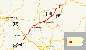
Pennsylvania Route 210 (PA 210) is a 30-mile-long (48 km) state highway located in Armstrong and Indiana Counties in Western Pennsylvania. The southern terminus is at PA 56/PA 156 in South Bend Township. The northern terminus is at US 119 near Covode.
Route description
PA 210 begins at an intersection with PA 56/PA 156 in South Bend Township, Armstrong County, heading northwest on a two-lane undivided road. The route crosses the Crooked Creek and continues into a mix of farmland and woodland with occasional homes, curving to the north. The road crosses into Plumcreek Township and passes through more rural areas, turning to the north-northeast. PA 210 comes to an intersection with US 422 southeast of Elderton and continues through more agricultural areas with some woods and residences, running a short distance to the northwest of Plum Creek. Farther northeast, the road crosses the North Branch Plum Creek and heads into more forested areas with a few fields and development, running near the southeastern shore of Keystone Lake. The route continues into Cowanshannock Township before heading into Atwood, turning east. PA 210 heads back into Cowanshannock Township and runs through more forests south of the lake. Past the lake, the road turns northeast through more farmland and woodland with some homes, passing through the residential community of Sagamore on Main Street before running through more rural areas.[1][2]
PA 210 enters South Mahoning Township in Indiana County and becomes an unnamed road as it passes through more farms and woods, coming to an intersection with PA 85. At this point, the route turns east for a concurrency with PA 85, coming to a junction with PA 954. Here, PA 954 turns east to join PA 85/PA 210. The three routes run through the residential community of Beyer before passing through more rural areas prior to entering Plumville. Here, the road becomes Main Street and passes homes and businesses. PA 954 splits from PA 85/PA 210 by turning north Smicksburg Street and PA 85/PA 210 continue northeast through more of the town. The road turns to the southeast and heads back into South Mahoning Township, becoming unnamed again. PA 210 splits from PA 85 by heading northeast into a mix of farmland and woodland with occasional homes. The road runs through rural areas for several miles, passing through the northwestern portion of East Mahoning Township before heading into North Mahoning Township. The route turns north as it comes to Trade City and intersects the northern terminus of PA 954 and turns to the east. PA 210 winds northeast through more farmland with some woods and residences, curving north again. The route makes another turn to the east and passes through more farms and woods before ending at US 119.[1][3]
Major intersections
| County | Location | mi[1] | km | Destinations | Notes |
|---|---|---|---|---|---|
| Armstrong | South Bend Township | ||||
| Plumcreek Township | |||||
| Indiana | South Mahoning Township | South end of PA 85 overlap | |||
| South end of PA 954 overlap | |||||
| Plumville | North end of PA 954 overlap | ||||
| South Mahoning Township | North end of PA 85 overlap | ||||
| North Mahoning Township | |||||
| 1.000 mi = 1.609 km; 1.000 km = 0.621 mi | |||||
See also
 U.S. Roads portal
 Pennsylvania portal
References
- 1 2 3 4 Google (August 20, 2011). "overview of Pennsylvania Route 210" (Map). Google Maps. Google. Retrieved August 20, 2011.
- ↑ Armstrong County, Pennsylvania Highway Map (PDF) (Map). PennDOT. 2011. Retrieved April 30, 2011.
- ↑ Indiana County, Pennsylvania Highway Map (PDF) (Map). PennDOT. 2011. Retrieved May 29, 2011.