Pennsylvania Route 145
| ||||
|---|---|---|---|---|
| Battle of the Bulge Veterans Memorial Highway | ||||
 | ||||
| Route information | ||||
| Maintained by PennDOT and City of Allentown | ||||
| Length: | 20.887 mi[1] (33.614 km) | |||
| Existed: | 1928 – present | |||
| Major junctions | ||||
| South end: |
| |||
|
| ||||
| North end: |
| |||
| Location | ||||
| Counties: | Lehigh, Northampton | |||
| Highway system | ||||
| ||||

Pennsylvania Route 145 (PA 145) is a 20.89 mi (33.62 km) long north–south state highway in the Lehigh Valley area of eastern Pennsylvania. It connects Interstate 78 (I-78) and PA 309 in Lanark, Lehigh County to PA 248 in Weiders Crossing, Northampton County. PA 145 is the main north-south arterial into Allentown, the third-largest city in the state. The route enters the city on South 4th Street and follows multiple streets to downtown, where it follows the one-way pair of 6th Street northbound and 7th Street southbound. North of Allentown in Whitehall Township, a seven-mile (11.2 km) portion of PA 145 is known as MacArthur Road, named in honor of General Douglas MacArthur. MacArthur Road is a divided highway; between U.S. Route 22 (US 22) and Eberhart Road, it is six lanes wide with a Jersey barrier and jughandles while the remainder of the road a four-lane divided highway. MacArthur Road is the location of the main commercial center of the Lehigh Valley. North of Eagle Point, PA 145 becomes a two-lane undivided road that parallels the Lehigh River, crossing the river into Northampton County at Treichlers. The route continues along the east bank of the river and passes through Walnutport before reaching its northern terminus. PA 145 is dedicated as the Battle of the Bulge Veterans Memorial Highway in honor of the veterans who fought in the Battle of the Bulge.
The section of road south of downtown Allentown was originally designated as part of US 309 when the U.S. Highway System was established in 1926. Between 1928 and 1930, PA 312 ran concurrent with US 309 on this stretch of road. PA 145 was first designated in 1928 between intersections with PA 45 (now PA 248) in Weiders Crossing and Bath, heading south to Cementon before turning east to Bath. A portion of PA 329 was designated between Cementon and Allentown along Coplay Road, Mickley Pike, and 7th Street, ending at US 22, US 309, PA 29, and PA 43 at 7th and Hamilton streets. The Seventh Street Pike was built between the 1920s and 1941 as a straight north-south road in Whitehall Township; PA 329 was relocated onto it in the 1930s. In 1941, PA 145 and PA 329 switched alignments, with PA 145 heading south along Seventh Street Pike and 7th Street to US 22/US 309/PA 29 at Tilghman Street in Allentown and PA 329 heading east to Bath. Seventh Street Pike was renamed to MacArthur Road in the early 1950s. In the 1950s, the southern terminus of PA 145 was cut back to the US 22 freeway in Whitehall Township and US 309 and PA 29 were rerouted to bypass Allentown. The MacArthur Road section of PA 145 was widened into a divided highway in 1970. In the 1980s, a proposal was made to extend PA 145 and US 222 through Allentown to provide numbered routes in the city. PA 145 was extended south to its current terminus by 1991.
Route description

PA 145 begins at an interchange with I-78 at exit 60 and PA 309 in the community of Lanark in Upper Saucon Township, Lehigh County. South of this interchange, the roadway continues southeast as part of PA 309 while northbound PA 309 heads west along I-78. From this interchange, PA 145 heads northwest on South Pike Avenue, a divided highway with two northbound lanes and one southbound lane. The road becomes undivided at the Vera Cruz Road/Oakhurst Derive intersection and ascends South Mountain with S-curves, passing through forested areas with some homes. The route reaches the community of Summit Lawn at the peak of South Mountain, where it intersects Rock Road, which heads southwest to provide access to westbound I-78/northbound PA 309. Here, PA 145 turns north and enters Salisbury Township, where it descends the mountain with one northbound lane and two southbound lanes through forests with a few residences. At the base of South Mountain, the route heads into the city of Allentown and becomes South 4th Street, heading into residential areas. The road crosses Emaus Avenue and narrows to two lanes, running north-northwest past businesses as it heads into the Mountainville neighborhood. PA 145 continues past homes and businesses, curving to the north as it passes to the east of a shopping center. After passing through the Mountainville neighborhood, the route turns west onto Susquehanna Street and passes over Norfolk Southern's Reading Line and Trout Creek.[2][3]
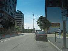
PA 145 curves north and becomes South 5th Street before it splits into a one-way pair. The northbound direction follows South 5th Street north and Auburn Street west to an intersection with South 6th Street and Lehigh Street while the southbound direction follows South 6th Street south and Wyoming Street east. The one-way streets, which carry two lanes of traffic in each direction, pass through urban residential neighborhoods, with northbound PA 145 passing Good Shepherd Hospital along South 5th Street. Past the one-way pair, the route follows Lehigh Street, a three-lane road with one northbound lane and two southbound lanes, through urban residential and commercial areas, crossing Little Lehigh Creek before intersecting Martin Luther King, Jr. Drive. After this intersection, the road ascends a long hill. PA 145 splits into another one-way pair at Union Street, with the northbound direction following two-lane South 6th Street and the southbound direction following three-lane South 7th Street. The route heads into the commercial downtown of Allentown, intersecting the northern terminus of northbound PA 222 at West Walnut Street, which is one-way eastbound. A block later, PA 145 intersects West Hamilton Street, with the Sailors and Soldiers Monument located at the center of the intersection between 7th and Hamilton streets. Past this intersection, northbound PA 145 follows North 6th Street and southbound PA 145 follows North 7th Street, with southbound PA 145 passing to the east of the PPL Center sports arena. Past the arena, the route intersects West Linden Street, which is one-way westbound and serves as the southbound beginning of PA 222. Continuing north, PA 145 leaves the downtown area and passes through urban areas of homes and businesses, intersecting Tilghman Street. A short distance later, northbound PA 145 turns west on two-way, two-lane West Washington Street to rejoin southbound PA 145 at North 7th Street.[2][3]
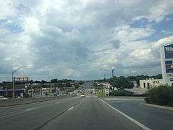
PA 145 continues north on North 7th Street, a three-lane road with one northbound lane and two southbound lanes that is lined with urban homes. The route widens to four lanes and crosses Sumner Avenue on a tall bridge, at which point it leaves Allentown for Whitehall Township. Here, the route becomes four-lane divided MacArthur Road and intersects Mickley Road/6th Street as it heads into commercial areas. The road crosses Jordan Creek and passes between businesses to the west and residential areas to the east before it comes to an interchange with the US 22 freeway. Past this interchange, PA 145 becomes a six-lane divided highway with a Jersey barrier and several intersections controlled by jughandles. The route traverses the main commercial center of the Lehigh Valley, passing to the west of Lehigh Valley Mall. After intersecting Grape Street, the road passes to the west of Whitehall Mall before coming to another intersection with Mickley Road. PA 145 continues past shopping centers and businesses, intersecting Schadt Avenue and curving to the northwest.[2][3]
After the Eberhart Road intersection in the community of Mickleys, the road narrows to a four-lane divided highway and runs through a mix of farmland and commercial development, turning to the north. The route continues through wooded areas with some nearby farms and residential commercial development and reaches an intersection with PA 329 in Eagle Point, located east of Egypt and west of Northampton. Past this intersection, PA 145 continues north through rural areas with some development, crossing into North Whitehall Township. The route intersects Second Street and narrows to a two-lane undivided, unnamed road as it heads along the west bank of the Lehigh River. The road continues through wooded areas alongside the river before it curves northwest away from it and reaches the community of Laurys Station. PA 145 passes homes and businesses, curving to the north again. The route heads into farmland with some homes, turning to the west and widening into a four-lane divided highway.[2][3]
PA 145 crosses the Lehigh River on the Treichlers Bridge, at which point it enters Lehigh Township in Northampton County. The route passes over Norfolk Southern's Lehigh Line before it descends off the Treichlers Bridge and intersects Blue Mountain Drive in the community of Treichlers. Past this, PA 145 heads south on two-lane undivided Riverview Drive and passes through a mix of farms and homes to the west of the river and the railroad tracks. The road begins a long curve to the west and then to the northwest as it continues parallel to the Lehigh River, heading into wooded areas with some development. The route passes through the community of Lockport and runs west through a mix of farms and woods before it enters the borough of Walnutport. PA 145 curves north and becomes South Best Avenue, heading through residential areas with some businesses. The route becomes North Best Avenue and heads into commercial areas, briefly becoming a divided highway before intersecting Main Street. The road becomes undivided again and continues into wooded areas with some development. The route leaves Walnutport for Lehigh Township again, where the name changes back to Riverview Drive. PA 145 continues north and reaches its northern terminus at PA 248 in the community of Weiders Crossing, a short distance south of the northern terminus of PA 873 at PA 248 and the Lehigh Gap in Blue Mountain. At the northern terminus, the route also encounters the Appalachian Trail.[2][4]
History
When routes were first legislated in Pennsylvania following the passage of the Sproul Road Bill in 1911, the present-day PA 145 corridor was legislated as part of Legislative Route 153 south of Allentown and as Legislative Route 175 in Northampton County.[5] With the creation of the U.S. Highway System in 1926, the present-day route heading south out of Allentown was designated as part of US 309.[6] In 1928, PA 312 was designated concurrent with US 309 between Center Valley and Allentown.[7] The concurrent PA 312 designation was removed from US 309 by 1930. US 309 entered Allentown from the south on Jordan Street (now South 4th Street) and intersected PA 43 at Susquehanna Street, at which point it turned west to join PA 43. US 309/PA 43 curved north on 5th Street and turned west on Auburn Street to intersect PA 29 at Lehigh Street. From here, US 309/PA 29/PA 43 continued north along Lehigh Street, Union Street, and 7th Street to the center of Allentown.[8]
PA 145 was first designated in 1928 to run from PA 45 (now PA 248) in Weiders Crossing east to PA 45 (now PA 248) in Bath, heading south along its current alignment and continuing along the river to Cementon, where it turned east and passed through Northampton before continuing to Bath.[7][9] When first designated, the route was paved between Treichlers and Bath.[7] By 1930, the entire length of PA 145 was paved.[9] The road between Cementon and Allentown was designated by 1930 as part of PA 329. This route followed Coplay Road from Cementon to Coplay and then ran along Mickley Pike through Whitehall Township before entering Allentown on 7th Street, where it ended at US 22, US 309, PA 29, and PA 43 at the intersection of 7th and Hamilton streets.[8][9] In the 1930s, PA 329 was realigned to follow Seventh Street Pike (now MacArthur Road) through Whitehall Township.[10] The Seventh Street Pike was built starting in the later part of the 1920s to provide a straight north-south road in Whitehall Township. The road between Allentown and Mickleys church was widened to three lanes in the 1930s.[11] The southern terminus of PA 329 was cut back to US 22, US 309, and PA 29 at Tilghman Street in Allentown in the 1930s, with US 309/PA 29 replacing the route along 7th Street between Tilghman and Hamilton streets. The concurrent PA 43 designation was also removed from US 309.[10][12] In 1941, PA 145 was realigned to follow Seventh Street Pike south from Eagle Point to Allentown and 7th Street in Allentown to US 22/US 309/PA 29 at 7th and Tilghman streets in Allentown, with PA 329 realigned to follow the former alignment of PA 145 between Cementon and Bath.[13][14] The section of Seventh Street Pike between Center Street and Eagle Point was constructed as a concrete road in 1941.[11] The portion of PA 145 along Seventh Street Pike was widened to four lanes between Allentown and west of Coplay by 1947.[15] In the early 1950s, Seventh Street Pike was renamed to MacArthur Road in honor of General Douglas MacArthur, a World War II hero.[11]
Following the completion of the US 22 freeway in 1955, the southern terminus of PA 145 was cut back to the cloverleaf interchange with I-78/US 22 in Whitehall Township.[16][17] Also, US 309 and PA 29 were rerouted to bypass Allentown to the south and west in the 1950s, leaving the former alignment unnumbered.[17][18] By 1961, PA 145 was realigned to bypass the center of Walnutport to the east along Best Avenue, having previously passed through the borough on Washington Street, Main Street, Cherry Street, and Spruce Street.[14][19] In 1970, PA 145 was widened into a divided highway between US 22 and north of PA 329.[20] The section of the route in Whitehall Township developed into a major retail center for the Lehigh Valley in the second half of the 20th century, with the construction of several businesses along with the Whitehall Mall and the Lehigh Valley Mall.[21] In 1984, PennDOT proposed to extend PA 145 to I-78 and PA 309 in Lanark. Traffic engineer Samuel D. Darrohh said that Allentown was one of few Pennsylvania cities without a traffic route going through it. He supported his idea by saying that motorists also might be aided if US 222 was extended along Hamilton Boulevard to connect with the proposed PA 145 corridor.[22] By 1991, the extension of PA 145 south from US 22 to I-78/PA 309 along its current alignment was completed.[23][24] PA 145 was dedicated as the Battle of the Bulge Veterans Memorial Highway in 2008 in honor of the veterans who fought in the Battle of the Bulge during World War II.[25] In 2012, a project began to improve PA 145's interchange with US 22. The project reconstructed the bridge carrying PA 145 over US 22 and replaced the cloverleaf interchange with a modified diamond interchange to improve traffic flow.[26] The reconstruction project, which cost $13.8 million, was planned to be finished in December 2013.[27]
Major intersections
| County | Location | mi[1] | km | Destinations | Notes |
|---|---|---|---|---|---|
| Lehigh | Upper Saucon Township | 0.000 | 0.000 | Access to PA 309 south and I-78 east, I-78 exit 60B | |
| Allentown | 3.993 | 6.426 | Northern terminus of PA 222 northbound | ||
| 4.293 | 6.909 | Northern terminus of PA 222 southbound | |||
| Whitehall Township | 6.039 | 9.719 | Interchange | ||
| 10.619 | 17.090 | ||||
| Northampton | Lehigh Township | 20.887 | 33.614 | ||
| 1.000 mi = 1.609 km; 1.000 km = 0.621 mi | |||||
See also
 U.S. Roads portal
 Pennsylvania portal
References
- 1 2 Bureau of Maintenance and Operations (January 2015). Roadway Management System Straight Line Diagrams (Report) (2015 ed.). Pennsylvania Department of Transportation. Retrieved June 30, 2015.
- Lehigh County (PDF)
- Northampton County (PDF)
- 1 2 3 4 5 Google (April 17, 2013). "overview of Pennsylvania Route 145" (Map). Google Maps. Google. Retrieved April 17, 2013.
- 1 2 3 4 Lehigh County, Pennsylvania Highway Map (PDF) (Map). PennDOT. 2012. Retrieved April 17, 2013.
- ↑ Northampton County, Pennsylvania Highway Map (PDF) (Map). PennDOT. 2012. Retrieved April 17, 2013.
- ↑ Map of Pennsylvania Showing State Highways (PDF) (Map). Pennsylvania Department of Highways. 1911. Retrieved January 1, 2014.
- ↑ Pennsylvania Highway Map (eastern side) (Map). Gulf Oil. 1926. Retrieved December 26, 2007.
- 1 2 3 Pennsylvania Highway Map (Philadelphia Metro) (Map). Gulf Oil. 1928. Retrieved November 8, 2007.
- 1 2 Tourist Map of Pennsylvania (back) (PDF) (Map). Pennsylvania Department of Highways. 1930. Retrieved January 8, 2015.
- 1 2 3 Tourist Map of Pennsylvania (PDF) (Map). Pennsylvania Department of Highways. 1930. Retrieved December 16, 2014.
- 1 2 Official Road Map of Pennsylvania (PDF) (Map). Pennsylvania Department of Highways. 1940. Retrieved June 24, 2010.
- 1 2 3 Fox, Martha Capwell (2004). Whitehall and Coplay. Images of America. Charleston, SC: Arcadia Publishing. p. 103. Retrieved January 22, 2015.
- ↑ Official Road Map of Pennsylvania (back) (PDF) (Map). Pennsylvania Department of Highways. 1940. Retrieved January 1, 2014.
- ↑ General Highway Map Lehigh County, Pennsylvania (PDF) (Map). Pennsylvania Department of Highways. 1941. Retrieved January 21, 2015.
- 1 2 General Highway Map Northampton County, Pennsylvania (PDF) (Map). Pennsylvania Department of Highways. 1941. Retrieved January 21, 2015.
- ↑ Newark, New Jersey 1:250,000 quadrangle (Map). United States Geological Survey. 1947. Retrieved 2009-11-28.
- ↑ Assad, Matt (September 19, 2004). "Route 22: Fifty years, one billion cars". The Morning Call. Allentown, PA.
- 1 2 Official Map of Pennsylvania (back) (PDF) (Map). Pennsylvania Department of Highways. 1960. Retrieved January 16, 2014.
- ↑ Official Map of Pennsylvania (PDF) (Map). Pennsylvania Department of Highways. 1960. Retrieved December 17, 2014.
- ↑ General Highway Map Northampton County, Pennsylvania (PDF) (Map). Pennsylvania Department of Highways. 1961. Retrieved January 26, 2015.
- ↑ Official Map of Pennsylvania (PDF) (Map). Pennsylvania Department of Highways. 1970. Retrieved December 17, 2014.
- ↑ Kennedy, Sam (March 9, 2008). "After 50 years, MacArthur Road becomes the Valley's $1.5 billion strip". The Morning Call. Allentown, PA. Retrieved January 23, 2015.
- ↑ Mellin, Ted (1984-07-31). "Route 145 Extension Through The City Receives Backing". The Morning Call. pp. B03. Retrieved 2007-04-16.
- ↑ Lehigh County (Sheet 1) (PDF) (Map). Pennsylvania Department of Transportation. 1991. Retrieved 2007-03-15.
- ↑ Lehigh County (Sheet 2) (PDF) (Map). Pennsylvania Department of Transportation. 1991. Retrieved 2007-03-23.
- ↑ Duck, Michael (May 21, 2008). "Route 145 dedicated to Battle of the Bulge veterans". The Morning Call. Allentown, PA. Retrieved January 24, 2015.
- ↑ "Whitehall Twp. – Upgrades to Rt. 22/Rt. 145 interchange, May 21 - Dec. 2013". The Morning Call. Allentown, PA. March 29, 2012. Retrieved January 23, 2015.
- ↑ Petty, Precious (November 25, 2013). "In time for Black Friday shopping, Routes 22 and 145 interchange project enters final phase". The Express-Times. Easton, PA. Retrieved January 23, 2015.
External links
| Wikimedia Commons has media related to Pennsylvania Route 145. |
- Multiplexed Roads - Pennsylvania Route 145 Junction list
- State Ends - Pennsylvania Route 145
- Pennsylvania Highways - Pennsylvania Route 145