Pelly Mountains
| Pelly Mountains | |
|---|---|
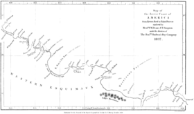 The Pelly Mountains in an 1837 map by Peter W. Dease and Thomas Simpson plotted during their Arctic expedition. | |
| Geography | |
| Country | Canada |
| State/Province | Yukon |
| Range coordinates | 61°35′N 133°11′W / 61.58°N 133.18°WCoordinates: 61°35′N 133°11′W / 61.58°N 133.18°W |
| Parent range | Yukon Ranges |
The Pelly Mountains are a mountain range in the Yukon, Canada. It has an area of 44014 km2 and is a subrange of the Yukon Ranges which in turn form part of the Pacific Coast Ranges.[1]
Sub-ranges
See also
References
- ↑ Pelly Mountains in the Canadian Mountain Encyclopedia
This article is issued from Wikipedia - version of the 8/24/2016. The text is available under the Creative Commons Attribution/Share Alike but additional terms may apply for the media files.