Pelješac
Coordinates: 42°55′N 17°28′E / 42.91°N 17.46°E

Pelješac (Croatian pronunciation: [pɛ̌ʎɛʃats]) (local Chakavian dialect: Pelišac; Italian: Sabbioncello) is a peninsula in southern Dalmatia[1] in Croatia. The peninsula is part of the Dubrovnik-Neretva County and is the second largest peninsula in Croatia. From the isthmus that begins at Ston, to the top of Cape Lovišta, it is 65 km or 40 mi long.
Etymology
The name Pelješac is most likely derived from the name of a hill above town of Orebić, which is Pelisac. This is a relatively new name for the peninsula. Throughout history other names have been used such as Stonski Rat, Puncta Stagni, Ponta di Stagno and Sabbioncello.
Geography

The Bay of Mali Ston separates the peninsula from the Klek peninsula of Bosnia and Herzegovina and from the Croatian "mainland". The Strait of Pelješac is located at its far western end, and it divides the peninsula from the island of Korčula. On the west part of Peninsula is the highest summit of Pelješac, 961 m or 3,153 ft.
Municipalities

Administratively the peninsula is divided into the municipalities of:
- Orebić in the western part, with 4,165 inhabitants (2001)
- Trpanj in the northwest, with 871 people
- Janjina in the center, 593 people
- Ston in the east, with 2,605 residents [2]
History
Prehistory
The earliest known historic records of Pelješac are from ancient Greece. The area became part of the Roman province of Dalmatia after the Illyrian Wars (220 BC to 219 BC.).[3] Roman migration soon followed. In the 6th century Pelješac came under Byzantine rule.
Middle Ages
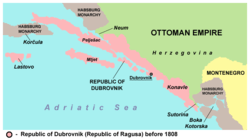
The Great Migrations of the 6th and 7th centuries, brought Avars and Slavs into the western Balkans. As the barbarians began settling on the coast, the Romanised local coastal population had to take refuge on the islands. Along the Dalmatian coast the Slavs poured in from the interior and seized control of the area where the Neretva River enters the Adriatic, to the Bay of Kotor. In De Administrando Imperio (ca. 960), this region was part of Zahumlje (Zachlumia), a "country" inhabited by Serbs.[4] Miroslav of Hum, the brother of Serbian Grand Prince Stefan Nemanja (r. 1166–96), held Zahumlje and had his capital at Ston.[5] Zahumlje (known henceforth as Hum) was a hereditary land of the Miroslavljević family. In 1219, Serbian Archbishop Sava established the Eparchy of Hum, which was seated in Ston. Eventually, Serbian king Stefan the First-Crowned (r. 1196–1228) intervened in local events, made a redistribution of lands and gave Ston and Pelješac to Petar's younger brother Andrija; Andrija ruled out of Ston until his death in 1250.[6] Andrija's son, Radoslav, was mentioned as a Hungarian vassal in 1254. During Stefan Uroš I's reign (1243–76), power was centralized, and the status of the Miroslavljević dropped to local nobility.[7] On 22 January 1325, Stefan Uroš III issued a document for the sale of his maritime possessions of the city of Ston and peninsula of Pelješac to the Republic of Ragusa.[8][9] In 1333, the two possessions were handed over to Ragusa.[10][7]
Modern history
The Walls of Ston are large fortifications built by the Republic of Ragusa.[11] They are the second longest walls in Europe. Ston also has one of the oldest salt planes in this part of the world.
The French Empire occupied the region in 1806, abolishing the old Republic, and in 1808 turned it into the Illyrian Provinces. In 1815 it was given to the Austrian Empire and since 1867 became part of the Cisleithania of the Dual Monarchy of Austria-Hungary. Between 1918 and 1991 it was a part of Yugoslavia.
Transport
Pelješac Bridge

An additional connection between Pelješac and the mainland is planned to be created through the proposal of the Pelješac Bridge. Once completed, this bridge would physically connect all of Croatia, which is now interrupted by the strip of land belonging to Bosnia and Herzegovina at Neum municipality. The land mass that cuts Dalmatia, Croatia in two, in order granting Bosnia and Herzegovina sea access. The start of construction has been continuously delayed until shipping rights and boundaries can be properly defined between the two countries.
See also
References
- ↑ John Everett-Heath. "Dalmatia." Concise Dictionary of World Place-Names. Oxford University Press. 2005. Encyclopedia.com
- ↑ "Stanovništvo prema narodnosti, po gradovima/općinama, Dubrovačko-neretvanska županija". Croatian Census 2001/Popis stanovništva 2001. (in Croatian). Croatian Bureau of Statistics.
- ↑ Wilkes, J. J. The Illyrians, 1992, p. 120, ISBN 0-631-19807-5,Page 160
- ↑ Constantine VII Porphyrogenitus (1993). De Administrando Imperio (Moravcsik, Gyula ed.). Washington D.C.: Dumbarton Oaks Center for Byzantine Studies. pp. 153–155.
- ↑ Pravoslavlje. Izdaje Srpska patrijaršija. 2007. p. 32.
- ↑ Синиша Мишић (2010). Лексикон градова и тргова средњовековних српских земаља: према писаним изворима. Завод за уџбенике. p. 289. ISBN 978-86-17-16604-3.
- 1 2 Fine, John Van Antwerp, Jr. (1994). The Late Medieval Balkans: A Critical Survey from the Late Twelfth Century to the Ottoman Conquest. Ann Arbor: University of Michigan Press. p. 203, 286. ISBN 978-0-472-08260-5.
- ↑ Srpska akademija nauka i umetnosti 1908, p. 252
- ↑ Istorijski institut u Beogradu, SANU 1976, p. 21
- ↑ Miloš Blagojević (2001). Državna uprava u srpskim srednjovekovnim zemljama. Službeni list SRJ. p. 211.
- ↑ Ston-www.croatia1.com
Further reading
- Mišić, Siniša (1997). Ston i Pelješac od 1326. do 1333. godine. Историјски часопис. 42-43. Istorijski institut. pp. 25–32. GGKEY:8N4K5PNPTJC.
External links
| Wikimedia Commons has media related to Pelješac. |
- http://www.peljesac.info/indexhr.htm
- http://www.peljesac.org/
- www.croatia1.com
- Kiteboarding Spots on Peljesac
- Apartments On Peljesac