Pelagonia Statistical Region
| Pelagonia Statistical Region Пелагониски регион | |
|---|---|
| statistical region | |
 | |
| Country |
|
| Area | |
| • Total | 4,719 km2 (1,822 sq mi) |
| Population (2014) | |
| • Total | 231,500 |
| • Density | 49/km2 (130/sq mi) |
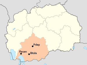
The Pelagonia Statistical Region (Macedonian: Пелагониски регион) is one of eight statistical regions of the Republic of Macedonia. It is located in southwestern part of the country along the eponymous plain. It borders Greece and Albania. Internally, it borders the Southwestern and Vardar statistical regions.
Municipalities
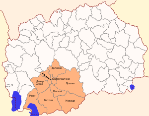
Map of the municipalities of the region
Pelagonia statistical region is divided into 9 municipalities:
Demographics

Map of the majority ethnic groups in the region
Population
The population of the Pelagonia Statistical Region is 238,136 citizens, or 11.8% of the population of the Republic of Macedonia, according to the census of 2002.
| Census Year | Population | Change |
|---|---|---|
| 1994 | 214,709 | N/A |
| 2002 | 238,136 | +10.91% |
Ethnicities
The largest ethnic group in the region are the Macedonians.
| Number | % | |
| TOTAL | 238,136 | 100 |
| Macedonians | 204,471 | 85.9 |
| Albanians | 11,634 | 4.9 |
| Romany | 7,230 | 3.0 |
| Turks | 7,150 | 3.0 |
| Bosniaks | 2,380 | 1.0 |
| Vlachs | 2,307 | 1.0 |
| Serbs | 713 | 0.3 |
| others | 2,251 | 1.0 |
See also
| Wikimedia Commons has media related to Pelagonia Statistical Region. |
Coordinates: 41°21′36″N 21°33′36″E / 41.36000°N 21.56000°E
This article is issued from Wikipedia - version of the 9/20/2016. The text is available under the Creative Commons Attribution/Share Alike but additional terms may apply for the media files.