Pekalongan
| Pekalongan | |||||
|---|---|---|---|---|---|
| City | |||||
| Other transcription(s) | |||||
| • Hanacaraka | ꦥꦺꦂꦏꦭꦺꦴꦔꦤ꧀ | ||||
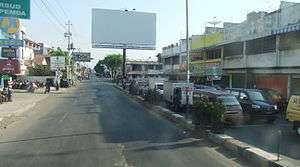
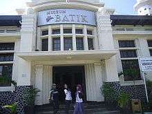
Clockwise, from top left : Jalan Kyai Mas Mansyur, Batik Museum, Pekalongan Railway Station | |||||
| |||||
|
Motto: Pekalongan Kota BATIK (Bersih, Aman, Tertib, Indah, Komunikatif) (Clean, Safe, Orderly, Beautiful, Communicative) | |||||
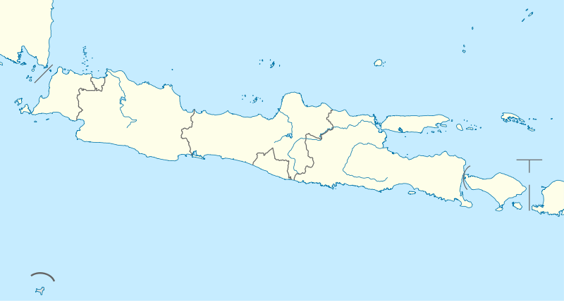 Pekalongan Location in Java | |||||
| Coordinates: 6°53′S 109°40′E / 6.883°S 109.667°ECoordinates: 6°53′S 109°40′E / 6.883°S 109.667°E | |||||
| Country | Indonesia | ||||
| Province | Central Java | ||||
| Regency | Pekalongan Regency | ||||
| Area | |||||
| • Total | 45 km2 (17 sq mi) | ||||
| Population (2013) | |||||
| • Total | 290,870 | ||||
| • Density | 6,500/km2 (17,000/sq mi) | ||||
| Website |
www | ||||

Pekalongan is a city of Central Java, Indonesia. It was formerly the seat of Pekalongan Regency on the northern coast of the province, but is now an independent municipality within the province. The city is Central Java's most important port, and is known for its batik. Since December 2014, Pekalongan is a member of UNESCO’s World’s Creative Cities Network. Pekalongan is the first Indonesian city and first South East Asian city listed as member of UNESCO’s World’s Creative Cities Network[1]
The Dutch name of the city is 'Pacalongan'.
History

The coastal area around Pekalongan was part of the ancient Holing (Kalingga) kingdom. The 7th century Sojomerto inscription, discovered in neighboring Batang Regency, Central Java, is linked with Kalingga as well as the ancestor of the Sailendras. The exact location of the Kalingga capital is unclear however, that it was suggested lies somewhere between Pekalongan and Jepara. However it is most likely that Kalingga was located in Pekalongan instead of Jepara, since there is similarity of names between Kalingga and Pekalongan. The name probably slightly shifted over centuries, from Kalingga, Kaling, Kalong, and later added with pe- -an circumfix forming "Pekalongan".
The history of Pekalongan dated back to the early 12th century. A book written in 1178 by a Song dynasty official already had record of Pekalongan, then known to Chinese merchants as "Pukalong", it was then a seaport of Java (then known as Dvapa); the king of Java lived at Pukalong, knotted his hair at the back of his head, while his people wore short hair and wrapped their body with colorfully weaved cloth.[2] Chinese merchant ship set sail from Canton during November, with the aid of fair wind sailed nonstop day and night, arrived at Pukalong in about one month. The people made wine from coconuts, produced very delicious red and white cane sugar, the kingdom made coins out of bronze and copper, 60 copper coins exchanged for one tael of gold. Local produces included pepper, clove, sandalwood, eaglewood and white round cardamom.[3]
Pekalongan became a part of the empire of the Sultanate of Mataram through treaty and marriage alliances by the early 17th century. The area was on the geographic periphery of the empire, which was based in interior central Java. However, it was a wealthy area, and by the end of the 17th century, the substantial money and produce it sent to the center made it a key part of Mataram's realm. The area went into economic decline during the 18th century, and the Dutch East India Company began to gain substantial influence over the area's political and economic life. The Dutch built a fort in the city in 1753; this fort still stands.

From the 1830s, the Pekalongan area became a major producer of sugar. Sugarcane had been grown in the area since early 12th century, as recorded in Chinese history books, but production expanded substantially during the mid-19th century due to Dutch efforts. Initially, production was boosted through compulsory corvée labor; the Dutch colonial government took advantage of longstanding Javanese expectations that the peasantry contributes a part of their labor to the state. Between the 1860s and the 1890s, this system was phased out, and workers were paid directly. The colonial sugar industry collapsed during the Great Depression of the 1930s, but sugar remains a key export of the area in independent Indonesia.
On October 8, 1945, an anti "Swapraja"/anti feudalism movement called Three Regions Movement/"Gerakan Tiga Daerah" was established in Tegal, Pekalongan, and Brebes. The goal of this movement was to replace the blue blood regents (related to the kings from Jogyakarta and Surakarta) with ordinary people. According to the leaders of this movement, the old regents had cooperated with Japanese during the world war II and sent people to the Japanese slave labor camps.
The main leader of this movement was Sarjiyo who became the new regent of Pekalongan. Other leaders of this movement were Kutil, K. Mijaya, and Ir. Sakirman. Ir Sakirman was the local leader of Indonesian Communist Party (PKI).
The old regents were arrested, stripped naked, and dragged into the prisons. Other government officials and police officers were kidnapped and massacred at Talang bridge. This movement also started a racial riot against ethnic Chinese in Brebes.
The government of Republic of Indonesia (RI) in Jogyakarta disagree with this movement and declared it as an illegal movement.
On November 4, 1945, the movement attacked Indonesian army HQ and the regent office in Pekalongan. The rebels were defeated by Indonesian army in a fierce battle on December 21, 1945. Most leaders of this movement were arrested and thrown into the prisons. This rebellion is called Three Regions Affair.
Geographic
Pekalongan city extend between 6º50’42”–6º55’44” South latitude and 109º37’55”–109º42’19” East longitude. Based on fictive coordinates, Pekalongan extend between 510.00 – 518.00 km longitudinal and 517.75 – 526.75 km crosswise. The farthest distance from north to south is ± 9 km, and west to east is ± 7 km. The administrative border of Pekalongan city are:
| North | Java Sea |
| South | Pekalongan Regency and Batang Regency |
| West | Pekalongan Regency |
| East | Batang Regency |
Pekalongan is divided into four districts and divided again into 27 villages with overall area is 45.25 km² or 0.14% from the area of Central Java.
| Climate data for Pekalongan | |||||||||||||
|---|---|---|---|---|---|---|---|---|---|---|---|---|---|
| Month | Jan | Feb | Mar | Apr | May | Jun | Jul | Aug | Sep | Oct | Nov | Dec | Year |
| Daily mean °C (°F) | 26.0 (78.8) |
26.5 (79.7) |
26.9 (80.4) |
27.4 (81.3) |
27.5 (81.5) |
27.0 (80.6) |
26.4 (79.5) |
26.7 (80.1) |
27.3 (81.1) |
27.6 (81.7) |
27.4 (81.3) |
26.8 (80.2) |
27.0 (80.6) |
| Average precipitation mm (inches) | 632.5 (24.902) |
415.4 (16.354) |
327.0 (12.874) |
195.1 (7.681) |
152.6 (6.008) |
87.7 (3.453) |
82.1 (3.232) |
74.2 (2.921) |
81.4 (3.205) |
143.6 (5.654) |
186.3 (7.335) |
319.5 (12.579) |
2,697.4 (106.197) |
| Average precipitation days | 18.4 | 16.6 | 16.5 | 13.8 | 10.6 | 8.5 | 4.7 | 4.5 | 5.2 | 8.8 | 14.8 | 17.6 | 140.0 |
| Source: [4] | |||||||||||||
Administrative districts
Pekalongan city is divided into four districts, listed below with their populations at the 2013 Pekalongan Data Statistic Book:[5]
- Pekalongan Barat (West Pekalongan) (91,306)
- Pekalongan Timur (East Pekalongan) (63,915)
- Pekalongan Utara (North Pekalongan) (77,791)
- Pekalongan Selatan (South Pekalongan) (57,858)
Transportation
Pekalongan city is easy to reach because Pekalongan is city crossings between Jakarta and Surabaya. In Pekalongan, there are transportation facilities, such as :
- Pekalongan Train Station, All passenger trains from west or east are stop in this station except Night trip of Argo Bromo Anggrek
- Pekalongan Bus Terminal
Tourism Place
Pekalongan has many tourism places, such as:
- Batik Museum
- Kauman Batik Tourism Village
- Pesindon Batik Tourism Village
- Medono ATBM (Non Automatic Weaving Machine) Tourism Village
- Landungsari Canting Tourism Village
- Pasir Kencana Beach
- Slamaran Indah Beach
- Pekalongan Mangrove Park
- Heroes Monument
- Jetayu Culture Area
Business
The city is known for its batik. The dyed fabric is produced both by hand in small-scale industries, and printed in larger factories. A mainstay of the economy, the industry collapsed during Indonesia's economic crisis in 1998, but it has partially recovered since. But now, Pekalongan has many business and industries places, such as :
- Traditional (wood) and Modern (fiberglass) Shipyard
- Small-scale batik industries
- Small-scale snack industries
- Fishing Port
- Fish canning factory
- Shopping mall
- Luxury Hotel
Natives
- George Junus Aditjondro, (1946-), sociologist
- Beb Bakhuys, (1909-1982), Dutch football player and manager
- Maria Dermoût (1888-1962), Indo novelist
- Hartono Rekso Dharsono, (1925-1996), first Secretary General of ASEAN
- Abdul Rahman Saleh, (1941-), former Attorney General of Indonesia
- Aziz Sattar (1925-2014), actor
- Hoegeng Iman Santoso, (1921-2004), (former Chief of the Indonesian National Police)
- Thio Tjin Boen, (1885-1940), novelist
- Joe Hin Tjio, (1919-2001), Scientist
Sources
- Knight, G.R. (1995) Gully Coolies, Weed-Women and Snijvolk: The Sugar Industry Workers of North Java in the Early Twentieth Century. Modern Asian Studies 28(1):51-76.
- Ricklefs, M.C. (1986) Some Statistical Evidence on Javanese Social, Economic and Demographic History in the Later Seventeenth and Eighteenth Centuries. Modern Asian Studies 20(1):1-32.
References
- ↑ "Wonderful Indonesia - Pekalongan: first Indonesian city included in UNESCO's World Creative Cities Network". www.indonesia.travel. Retrieved 2015-08-16.
- ↑ this means that the people of Pugalong had already batik in 12th century
- ↑ Song dynasty Zhou Qufei: Ling Wai Dai Da (Reports from Beyong the Southern Mountains) in Chinese ISBN 7-101-01665-0. Unfortunately no English translation available, the above paragraph is my GFDL translation
- ↑ "Pekalongan, Indonesia Travel Weather Averages". Weatherbase. Retrieved 7 February 2016.
- ↑ Badan Pusat Statistik, Kota Pekalongan, 2014
External links
- (Indonesian) Military History Centre/Three regions affair
- (Indonesian) Military History Centre/Battle on December 21, 1945
- Pekalongan official government website
- Requests for Wikipedia Boso Kalongan
- Pekalongan's Creative City website
Regencies and cities of Central Java | ||
|---|---|---|
Capital: Semarang | ||
| Regencies |  | |
| Cities | ||
| Villages | ||