Peirce quincuncial projection
The Peirce quincuncial projection[1] is a conformal map projection developed by Charles Sanders Peirce in 1879.
History
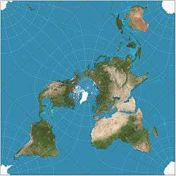
The maturation of complex analysis led to general techniques for conformal mapping, where points of a flat surface are handled as numbers on the complex plane. While working at the U.S. Coast and Geodetic Survey, the American philosopher Charles Sanders Peirce published his projection in 1879 (Peirce 1879),[2] having been inspired by H. A. Schwarz's 1869 conformal transformation of a circle onto a polygon of n sides (known as the Schwarz–Christoffel mapping). In the normal aspect, Peirce's projection presents the Northern Hemisphere in a square; the Southern Hemisphere is split into four isosceles triangles symmetrically surrounding the first one, akin to star-like projections. In effect, the whole map is a square, inspiring Peirce to call his projection quincuncial, after the arrangement of five items in a quincunx.
After Peirce presented his projection, two other cartographers developed similar projections of the hemisphere (or the whole sphere, after a suitable rearrangement) on a square: Guyou in 1887 and Adams in 1925.[3] The three projections are transversal versions of each other (see related projections below).
Formal description
The Peirce quincuncial projection is "formed by transforming the stereographic projection with a pole at infinity, by means of an elliptic function" (Peirce, 1879). The Peirce quincuncial is really a projection of the hemisphere, but its tessellation properties (see below) permit its use for the entire sphere. Peirce's projection maps the interior of a circle (corresponding to each hemisphere, which were created by projecting them using the stereographic projection) onto the interior of a square (using the Schwarz–Christoffel mapping) (Lee, 1976).
A point P on the Earth's surface, a distance p from the North Pole with longitude θ and latitude λ is first mapped to a point (p, θ) of the plane through the equator, viewed as the complex plane with coordinate w; this w coordinate is then mapped to another point (x, y) of the complex plane (given the coordinate z) by an elliptic function of the first kind. Using Gudermann's notation for Jacobi's elliptic functions, the relationships are

The equator is mapped to a square with the Pole at its center at z = K( 1⁄√2) ≈ 1.854, where K(k) is the complete elliptic integral of the first kind. The square is oriented diagonally such that one of the corners of the square lies at z = 0 which coincides with θ = 0.
Properties
According to Peirce, his projection has the following properties (Peirce, 1879):
- The sphere is presented in a square.
- The part where the exaggeration of scale amounts to double that at the centre is only 9% of the area of the sphere, against 13% for the Mercator projection and 50% for the stereographic projection.
- The curvature of lines representing great circles is, in every case, very slight, over the greater part of their length.
- It is conformal everywhere except at the four corners of the inner hemisphere (thus the midpoints of edges of the projection), where the equator and four meridians change direction abruptly (the equator is represented by a square). These are singularities where differentiability fails.
- It can be tessellated in all directions.
Tiled Peirce quincuncial maps
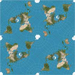
The projection tessellates the plane; i.e., repeated copies can completely cover (tile) an arbitrary area, each copy's features exactly matching those of its neighbors. (See the example to the right). Furthermore, the four triangles of the second hemisphere of Peirce quincuncial projection can be rearranged as another square that is placed next to the square that corresponds to the first hemisphere, resulting in a rectangle with aspect ratio of 2:1; this arrangement is equivalent to the transverse aspect of the Guyou hemisphere-in-a-square projection.[4]
Known uses
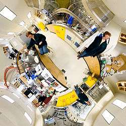
Like many other projections based upon complex numbers, the Peirce quincuncial has been rarely used for geographic purposes. One of the few recorded cases is in 1946, when it was used by the U.S. Coast and Geodetic Survey world map of air routes.[4] It has been used recently to present spherical panoramas for practical as well as aesthetic purposes, where it can present the entire sphere with most areas being recognizable[5]
Related projections
In transverse aspect, one hemisphere becomes the Adams hemisphere-in-a-square projection (the pole is placed at the corner of the square). Its four singularities are at the North Pole, the South Pole, on the equator at 25°W, and on the equator at 155°E, in the Arctic, Atlantic, and Pacific oceans, and in Antarctica.[6] That great circle divides the traditional Western and Eastern hemispheres.
In oblique aspect (45 degrees) of one hemisphere becomes the Guyou hemisphere-in-a-square projection (the pole is placed in the middle of the edge of the square). Its four singularities are at 45 degrees north and south latitude on the great circle composed of the 20°W meridian and the 160°E meridians, in the Atlantic and Pacific oceans.[6] That great circle divides the traditional western and eastern hemispheres.
See also
References
- ↑ A Quincuncial Projection of the Sphere by Charles Sanders Peirce. 1890.
I. Frischauf. Bemerkungen zu C. S. Peirce Quincuncial Projection. (Tr., Comments on C. S. Peirce Quincuncial Projection.)
A Treatise on Projections by Thomas Craig. U.S. Government Printing Office, 1882. p132
Science, Volume 11. Moses King, 1900. p186 - ↑ (Lee, 1976) gives 1877 as the year in which the projection was conceived, citing "US Coast Survey Report for the Year Ending with June 1877", 191–192.
- ↑ Lee, L. P. (1976). "Conformal Projections Based on Jacobian Elliptic Functions". Cartographica: The International Journal for Geographic Information and Geovisualization. 13: 67–101. doi:10.3138/X687-1574-4325-WM62.
- 1 2 Snyder, John P. (1989). An Album of Map Projections, Professional Paper 1453 (PDF). US Geological Survey. pp. 190, 236.
- ↑ German, Daniel; d'Angelo, Pablo ; Gross, Michael and Postle, Bruno (June 2007). "New Methods to Project Panoramas for Practical and Aesthetic Purposes". "Proceedings of Computational Aesthetics 2007". Banff: Eurographics. pp. 15–22. Cite uses deprecated parameter
|coauthors=(help) - 1 2 Carlos A. Furuti. Map Projections:Conformal Projections.
Further reading
- Peirce, C. S. (1877/1879), "Appendix No. 15. A Quincuncial Projection of the Sphere", Report of the Superintendent of the United States Coast Survey Showing the Progress of the Survey for Fiscal Year Ending with June 1877, pp. 191–194 followed by 25 progress sketches including (25th) the illustration (the map itself). Full Report submitted to the Senate December 26, 1877 and published 1880 (see further below).
- Article first published December 1879, American Journal of Mathematics 2 (4): 394–397 (without the sketches except final map), Google Books Eprint (Google version of map is partly botched), JSTOR Eprint, doi:10.2307/2369491. AJM version reprinted in Writings of Charles S. Peirce 4:68–71.
- Article reprinted 1880 including publication of all sketches, in the full Report, by the U.S. Government Printing Office, Washington, D.C. NOAA PDF Eprint, link goes to Peirce's article on Report's p. 191, PDF's p. 215. NOAA's PDF lacks the sketches and map and includes broken link to their planned online location, NOAA's Historical Map and Chart Collection, where they do not seem to be as of 7/19/2010. Google Books Eprint (Google botched the sketches and partly botched the illustration (the map itself).) Note: Other Google edition of 1877 Coast Survey Report completely omits the pages of sketches including the illustration (the map).
External links
| Wikimedia Commons has media related to Peirce quincuncial projection. |
- An interactive Java Applet to study the metric deformations of the Peirce Projection.
- More examples of Peirce quincuncial panoramas
- Snyder, John P. (1989). An Album of Map Projections, Professional Paper 1453 (PDF). US Geological Survey. pp. 190, 236. Contains history, description, and formulation more suited to computation.