Island of Peace
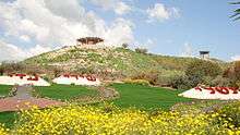
The Island of Peace is an area which is under Jordan's sovereignty with Israeli private land ownership rights and property interests.[1] The park is at the confluence of the Jordan River and Yarmouk River.[2] Pinhas Rutenberg's Naharayim hydroelectric power station can be seen from here.
History
Land along the Jordan River's alluvial slopes and floor bed was under Jewish ownership before the establishment of the State of Israel.[3] In 1927, Pinchas Rutenberg, founder of the Palestine Electric Company, signed an agreement with King Abdullah I of Jordan to build a hydroelectric power station. The canals and dams built for this purpose created a man-made island. The plant began supplying electricity in 1932. Operations were shut down in the wake of the 1948 Arab-Israeli War.[4]
In 1994, Israel ceded the area to Jordan as part of the Israel-Jordan Treaty of Peace. Jordan agreed to lease it back so the Israeli farmers from Kibbutz Ashdot Ya'acov could continue to cultivate the land.[2] Farming continues under a 25-year, automatically renewable lease. A gate was established to enable Israeli tourists to visit the park without a visa or passport, on presentation of their identity cards to the Jordanian guards at the border crossing.[3]
1997 massacre

On March 13, 1997, the AMIT Fuerst (Fürst) Zionist religious junior high school from Beit Shemesh was on a class trip to the Jordan Valley, and Island of Peace. Jordanian soldier Ahmed Daqamseh opened fire at the schoolchildren, killing seven girls aged 13 or 14 and badly wounding six others. King Hussein of Jordan came to Beit Shemesh to extend his condolences and ask forgiveness in the name of his country, a step which was seen as both touching and courageous.[5]
Daqamseh was convicted by a military tribunal to several consecutive life sentences; one life sentence (or several, unclear due to inconsistencies in press reports) means in Jordan that he has to serve a total of 25 years in prison. The death penalty was not considered because the court ruled he was mentally unstable.[6][7] In February 2011, Jordan's justice minister Hussein Mjalli demanded at a demonstration the early release of Daqamseh, claiming that "He's a hero, he doesn’t deserve to be imprisoned".[8][9] Jordan's Foreign Ministry subsequently declared that this was just Mjali's personal opinion and reassured Israel that Daqamseh will serve out his life sentence.[6] In April 2013, 110 of the 120 members of the Jordanian House of Representatives signed a petition demanding a pardon for Daqamseh, but the Jordanian Prosecutor's Office has refused to pursue the pardon process. The final authority in the matter is King Abdullah, son of the late king Hussein, who is unlikely to consider such a move.[7]
References
- ↑
- 1 2 The beautiful and tragic story of Naharayim, Jerusalem Post
- 1 2 Jordan River Valley Peace Park
- ↑ Jordan River Peace Park
- ↑ "With condolence visit to Israel, King Hussein spurs talks", CNN, March 16, 1997. Accessed July 22, 2007. "King Hussein of Jordan knelt in mourning Sunday with the families of seven Israeli schoolgirls gunned down last week by a Jordanian soldier, saying they were all 'members of one family.'"
- 1 2 The Associated Press (12 April 2013). "Jordan: Killer of Israeli schoolchildren will serve his life sentence". Haaretz. Retrieved 5 February 2015.
- 1 2 Jack Khoury (16 February 2011). "Sweeping majority of Jordan MPs sign petition calling for release of man who killed 7 Israeli girls". Haaretz. Retrieved 5 February 2015.
- ↑ "Jordan minister: Release soldier who shot Israelis". Jerusalem Post. February 14, 2011. Retrieved September 1, 2011.
In an unprecedented move, Jordan's new justice minister on Monday joined dozens of protesters demanding the early release of a Jordanian soldier who killed seven Israeli school girls in 1997
- ↑ Roee Nahmias (16 February 2011). "Jordanian minister calls Israel 'enemy'". Ynet News. Retrieved 24 September 2011.
External links
- Area in images (explanations in Hebrew)
- Images of the schoolgirls killed in the massacre (explanation in Hebrew)
Coordinates: 32°38′26″N 35°34′0″E / 32.64056°N 35.56667°E