Peace Bridge
- This article is about the Peace Bridge between the USA and Canada. For other Peace Bridges, see Peace Bridge (disambiguation).
| Peace Bridge | |
|---|---|
|
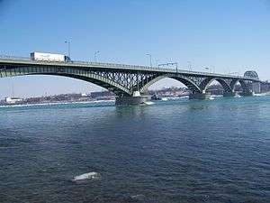
Peace Bridge from the Canadian side. | |
| Coordinates | 42°54′25″N 78°54′20″W / 42.90694°N 78.90556°WCoordinates: 42°54′25″N 78°54′20″W / 42.90694°N 78.90556°W |
| Carries |
3 reversible lanes of |
| Crosses | Niagara River |
| Locale | Fort Erie, Ontario and Buffalo, New York |
| Maintained by | Buffalo and Fort Erie Public Bridge Authority (Peace Bridge Authority) |
| Characteristics | |
| Design | through truss and arch bridge |
| Total length | 5,800 feet (1.77 km) |
| Longest span | 130 m |
| History | |
| Opened | June 1, 1927 |
| Statistics | |
| Toll | $3.00 USD, $4.00 CAD ($2.70 USD with E-ZPass) [1] |
The Peace Bridge is an international bridge between Canada and the United States at the east end of Lake Erie at the source of the Niagara River, about 20 kilometres (12.4 mi) upriver of Niagara Falls. It connects Buffalo, New York, in the United States to Fort Erie, Ontario, in Canada. It is operated and maintained by the binational Buffalo and Fort Erie Public Bridge Authority.[2]
The Peace Bridge consists of five arched spans over the Niagara River and a Parker through-truss span over the Black Rock Canal on the American side of the river. The length is 5,800 feet (1.77 km). Material used in the construction included 3,500 feet (1.07 km) of steelwork, 9,000 tons of structural steel and 800 tons of reinforcing steel in the concrete abutments. The Peace Bridge was named to commemorate 100 years of peace between the United States and Canada. It was constructed as a highway bridge to address pedestrian and motor vehicle traffic which could not be accommodated on the International Railway Bridge, built in 1873.
History
The building of the Peace Bridge was approved by the International Joint Commission on August 6, 1925. Edward Lupfer served as chief engineer.[3] A major obstacle to building the bridge was the swift river current, which averages 7.5 to 12 miles per hour (12.1 to 19.3 km/h). Construction began in 1925 and was completed in the spring of 1927. On March 13, 1927, Lupfer drove the first car across the bridge. On June 1, 1927, the bridge was opened to the public.
The official opening ceremony was held two months later, on August 7, 1927, with approximately 100,000 in attendance. The festivities were transmitted to the public via radio in the first international coast-to-coast broadcast. Newspapers at the time estimated that as many as 50 million listeners may have heard the broadcast.
The dignitaries who took part in the dedication ceremonies included The Prince of Wales (the future Edward VIII), Prince George, Canadian Prime Minister William Lyon Mackenzie King, British Prime Minister Stanley Baldwin, U.S. Vice President Charles Dawes, Secretary of State Frank Kellogg, New York Governor Al Smith and Ontario Premier Howard Ferguson.[4]
When the bridge opened, Buffalo and Fort Erie each became the chief port of entry to their respective countries from the other. At the time it was the only vehicular bridge on the Great Lakes from Niagara Falls to Minnesota. The bridge remains one of North America's important commercial ports with four thousand trucks crossing it daily.
After new toll facilities were installed on the Canadian side in 2005, the Peace Bridge became the first E-ZPass facility outside the United States.
Alternatives
The Buffalo and Fort Erie Public Bridge Authority in 1997 announced plans for the building of a second bridge south of and beside the Peace Bridge. It was expected the new bridge would alleviate traffic congestion and increase daily vehicle traffic by at least 33%. Legal challenges as well as concerns about the design and how costs will be paid delayed the start of construction. While the Jury Recommendation Report originally recommended a cable-stayed bridge "signature bridge" for the new span, the option was overruled in favour of a more conventional design due to concerns that endangered birds would possibly fly into the bridge.[5] Local authorities are appealing the decision.
Other nearby bridges between the United States and Canada include the Rainbow Bridge, the Queenston-Lewiston Bridge and the Whirlpool Rapids Bridge. The Queenston-Lewiston Bridge and the Peace Bridge are the only crossings that allow heavy trucks.
Customs inspection and toll plazas
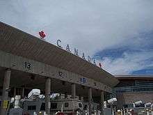
There are customs plazas at both ends of the bridge, with the Canadian plaza the newer and larger of the two.
The inbound customs plaza in the United States has seven lanes for trucks and nine for cars. Pedestrians and cyclists are processed to the left of the truck inspection area.[6]
The inbound customs plaza in Canada was designed by NORR Limited Architects and Engineers and completed in 2010.[7] There are 14 booths/lanes for cars and a separate area for trucks (handling five trucks at a time). Pedestrians and cyclists are processed in an area on the right side of the inspection area for cars.[6]
Once vehicles leave the customs plaza in Canada vehicles approach a smaller toll plaza to pay toll for using the Peace Bridge. Payment for tolls are either cash (US or Canadian), EZPass, as well as old Peace Bridge tokens.[8] There are no toll booths on the US side[1] and no tolls for pedestrians or cyclists.[8]
Preclearance
In October 2012 it was announced by the DHS and Public Safety Canada that a pilot program, years in the works, to preclear all truck traffic from Canada into Buffalo would be commenced. The pilot would start in late December 2012 and run for 18 months, after which the economic benefits would be assessed and its feasibility to make permanent would then be recommended to both U.S Congress and Canadian Parliament.[9][10]
Road connections
On the New York side, Interstate 190 has a direct northbound off-ramp (exit 9) onto the Peace Bridge. This exit is signed as "Ft Erie Can" on I-190, but the bridge is actually Baird Drive. Baird Drive is not signed on the exit, but the road does head south of the bridge to its southern terminus of Porter Avenue and Front Park. On the Ontario side, the Queen Elizabeth Way begins after (and ends at) Canadian Customs plaza.
Before 1972, this border point was one of two southern terminus for the Queen Elizabeth Way. The alternate end was at the Rainbow Bridge in Niagara Falls section of the QEW. With the designation Highway 420, the Fort Erie end was the only end for the freeway.
Commemorations
- The Peace Bridge March, by Buffalo resident Emma M. Herold-Haft, was composed in honor of the bridge's opening in 1927.
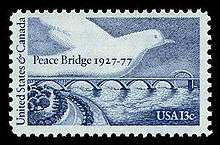
- On August 4, 1977, Canada and the United States brought out a joint issue of postage stamps to commemorate the 50th anniversary of the bridge. Unusual for joint issues, the two designs are radically different (the US was all blue and the Canadian was a full colour).
See also
References
- 1 2 http://www.peacebridge.com/index.php?option=com_content&view=article&id=19&Itemid=662
- ↑ The Peace Bridge (What Else?) Sets Off a Cuomo-Canada War May 27, 2013 NYT
- ↑ Berketa, Rick. "Bridges Over Niagara Falls:a history & pictorial". Niagara Falls Thunder Alley. Retrieved 7 August 2011.
- ↑ Peace Bridge Celebrates its 75th Anniversary
- ↑ Jennifer Pellegrini. "Peace Bridge Authority goes to Plan B". Niagara Falls Review. Retrieved 7 August 2011.
- 1 2 http://www.peacebridge.com/index.php?option=com_content&view=article&id=50&Itemid=723
- ↑ http://www.tc.gc.ca/eng/mediaroom/releases-2010-h139e-6192.htm
- 1 2 http://www.peacebridge.com/index.php?option=com_content&view=article&id=19&Itemid=638
- ↑ http://www.berardiimmigrationlaw.com/immigration-blog/new-cbpuscis-inspection-procedures-for-trucks-crossing-peace-bridge
- ↑ U.S., Canada forge new inspection agreement
Further reading
- Peter R. Eisenstadt; Laura-Eve Moss (2005). The Encyclopedia Of New York State. Syracuse University Press. p. 240.
External links
| Wikimedia Commons has media related to Peace Bridge. |
- Peace Bridge Authority
- Peace Bridge at Structurae
- Images from the Historic Niagara Digital Collections
| Bridges of the Niagara River | ||||
|---|---|---|---|---|
| ||||