Peabody, Massachusetts
| Peabody, Massachusetts | ||
|---|---|---|
| City | ||
|
Peabody | ||
| ||
| Nickname(s): Tanner City, The Leather City[1] | ||
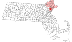 Location in Essex County in Massachusetts | ||
 Peabody, Massachusetts Location in the United States | ||
| Coordinates: 42°31′40″N 70°55′45″W / 42.52778°N 70.92917°WCoordinates: 42°31′40″N 70°55′45″W / 42.52778°N 70.92917°W | ||
| Country | United States | |
| State | Massachusetts | |
| County | Essex | |
| Settled | 1626 | |
| Incorporated | 1855 | |
| City | 1916 | |
| Government | ||
| • Type | Mayor-council city | |
| • Mayor | Edward A. Bettencourt, Jr. | |
| Area | ||
| • Total | 16.8 sq mi (43.5 km2) | |
| • Land | 16.2 sq mi (42.0 km2) | |
| • Water | 0.6 sq mi (1.5 km2) | |
| Elevation | 17 ft (5 m) | |
| Population (2010) | ||
| • Total | 51,251 | |
| • Estimate (2014) | 52,376 | |
| • Density | 3,231/sq mi (1,247.4/km2) | |
| Time zone | Eastern (UTC-5) | |
| • Summer (DST) | Eastern (UTC-4) | |
| ZIP code | 01960 / 01961 | |
| Area code(s) | 351 / 978 | |
| FIPS code | 25-52490 | |
| GNIS feature ID | 0614307 | |
| Website |
www | |


Peabody /ˈpiːbədi/ is a city in Essex County, Massachusetts, United States. At the 2010 census, the population was 51,251,[2] and in 2014 the estimated population was 52,376. Peabody is located in the North Shore region of Massachusetts.
History
First known as the Northfields, "the Farms", and Brooksby, the area was settled about 1626 within Salem, which had itself been founded in 1626 and incorporated in 1629. In 1752, the area was set off from Salem and incorporated as part of Danvers. It was usually referred to as "the South Parish", associated with the church located in the center (now Peabody Square). In 1855, the community broke away from Danvers to become the town of South Danvers, incorporated that May 18. The name was changed on April 30, 1868, to Peabody after George Peabody, a noted philanthropist. It would be incorporated as a city in 1916.
The town began as a farming community, but its streams attracted mills which operated by water power. In particular, Peabody was a major center of New England's leather industry, which attracted immigrants from all around the world. By 1915, a third of the population was foreign-born.[3] In addition to becoming home to large Irish and Russian populations, Peabody notably developed a large community of laborers hailing from the Ottoman Empire, mostly Turkish- and Kurdish-speakers from the region of Harput (now known as Elazığ).[3] The population was situated primarily on Walnut Street, where they filled boarding houses and coffee houses to such an extent that it became known as "Ottoman Street," and, more pejoratively and less accurately, "Peabody's Barbary Coast."[3] One visitor even noted that signs in town were written in both English and Ottoman Turkish.[3]

On the morning of October 28, 1915, 21 young girls lost their lives in a fire at the St. John's School on Chestnut Street in the downtown area. The 21 girls who were trapped were found after the fire subsided, huddled together and burnt beyond recognition, on the other side of the entrance - just steps away from survival. All the teachers escaped with their lives. The students' deaths were privately mourned in Peabody and were rarely mentioned, as many tried to forget the tragedy. Because of this, Peabody became the first city to make a law that said all doors must push out.[4][5]
The tanneries that helped create Peabody's "Ottoman Street" remained a linchpin of the city's economy into the second half of the 20th century. The tanneries have since closed, but the city remains known locally as the Leather City or Tanner City, and its high school sports teams are nicknamed the Tanners which continues to be the mascot today.
The loss of the tanneries was a blow to Peabody's economy, but the city has made up for the erosion of its industrial base, at least in part, through other forms of economic development. Early in the 20th century, it joined the automobile revolution, hosting the pioneer Brass Era company the Corwin Manufacturing Company.[6] The Northshore Mall, originally the Northshore Shopping Center, is one of the region's largest malls. It opened in 1958 and is now the city's largest taxpayer. Centennial Park,[7] an industrial park in the center of the city, has attracted several medical and technology companies.
Meanwhile, West Peabody, which was mostly farmland as recently as the 1950s, has been developed into a middle-to-upper class residential area.
Brooksby Farm,[8] a historic farm managed by the City of Peabody, is a 275-acre (1.11 km2) working farm and conservation area that has been one of the city's most popular destinations for decades.
Peabody is the location of the Salem Country Club, a private country club with a professional golf course. In the past, the club has hosted the U.S. Senior Open in 2001 and the U.S. Women's Open in 1954 and 1984.
 City Hall in 1912
 Peabody Square c. 1906
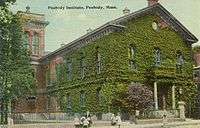 Peabody Institute Library c. 1912
Geography
Peabody is located at 42°32′3″N 70°57′41″W / 42.53417°N 70.96139°W (42.534045, -70.961465).[9] According to the United States Census Bureau, the city has a total area of 16.8 square miles (43.5 km2), of which 16.2 square miles (42.0 km2) is land and 0.58 square miles (1.5 km2) or 3.46%, is water.[2] The northwestern border of Peabody lies along the Ipswich River, with brooks feeding it, and the Waters River, a tributary of the Danvers River, drains the northeast part of town. Several other ponds and a portion of Suntaug Lake lie within town. The largest protected portion of the city is the Brooksby Farm, whose land includes the Nathaniel Felton Houses.
The city is wedge-shaped, with the city center located in the wider southeast end. The neighborhood of South Peabody lies south of it, and the more suburban neighborhood of West Peabody lies to the northwest of the city center, separated by the highways and the Proctor neighborhood. Peabody's center is 2 miles (3 km) from the center of Salem, and is 15 miles (24 km) northeast of Boston, 18 miles (29 km) west-southwest of Gloucester, and 18 miles (29 km) southeast of Lawrence. Peabody is bordered by Middleton to the northwest, Danvers to the northeast, Salem to the east, Lynn to the south and Lynnfield to the west.
Demographics
| Historical population | ||
|---|---|---|
| Year | Pop. | ±% |
| 1860 | 6,549 | — |
| 1870 | 7,343 | +12.1% |
| 1880 | 9,028 | +22.9% |
| 1890 | 10,158 | +12.5% |
| 1900 | 11,523 | +13.4% |
| 1910 | 15,721 | +36.4% |
| 1920 | 19,552 | +24.4% |
| 1930 | 21,345 | +9.2% |
| 1940 | 21,711 | +1.7% |
| 1950 | 22,645 | +4.3% |
| 1960 | 32,202 | +42.2% |
| 1970 | 48,080 | +49.3% |
| 1980 | 45,976 | −4.4% |
| 1990 | 47,039 | +2.3% |
| 2000 | 48,129 | +2.3% |
| 2010 | 51,251 | +6.5% |
| 2014 | 52,376 | +2.2% |
| 2015 | 52,504 | +0.2% |
| * = population estimate. Source: United States Census records and Population Estimates Program data.[10][11][12][13][14][15][16][17] Source: | ||
As of the census of 2010,[2] there were 51,251 people residing in the city and a total of 22,220 housing units. The racial makeup of the city was 90.4% White, 2.4% African American. 6.3% Hispanic or Latino of any race (1.3% Puerto Rican, 0.3% Mexican, 0.1% Cuban, and 4.5% other Hispanic or Latino), 1.9% Asian, 3.8% from other races, and 1.6% from two or more races.
There were 21,313 households, of which 26.8% included children under the age of 18, 48.4% were married couples living together, 10.7% had a female householder with no husband present, and 37.1% were non-families. 31.4% of all households were made up of individuals, and 16.3% had someone living alone who was 65 years of age or older. The average household size was 2.28, and the average family size was 3.02.
In the city the population was spread out, with 21.1% under the age of 20, 22.5% from 20 to 39, 29.8% from 40 to 59, and 26.5% who were 60 years of age or older. The median age of people in Peabody was 44.6. For every 100 females there were 90.3 males. For every 100 females age 18 and over, there were 86.9 males.
The median income for a household in the city was $65,515, and the median income for a family was $80,471. Males had a median income of $55,352 versus $44,167 for females. About 4.4% of families and 6.3% of the population were below the poverty line, including 5.8% of those under age 18 and 7.9% of those age 65 or over.
In the April 2009 edition of Forbes magazine, Peabody was ranked the 14th most livable city in the United States.[19]
Economy

- Major employers
- Analogic Corporation
- Boston Children's Hospital Peabody Campus
- Boston Acoustics
- Carl Zeiss AG Nano Technology Systems Division
- Christian Book Distributors
- JEOL USA
- Lahey Hospital & Medical Center (formerly the Lahey Clinic)
- Meridian Interstate Bancorp Headquarters, holding company of East Boston Savings Bank
- Northshore Mall
- Rousselot Gelatine, formerly Eastman Gelatine division of Kodak
- Saucony
- UTC Aerospace Systems, formerly Walbar Metals Goodrich
Education
Peabody Veterans Memorial High School is a grade 9-12 public high school located in Peabody. The teams are known as the Peabody Tanners. As of April 2008, there were 1,898 students enrolled in the school, and 146 teachers.[20]
Bishop Fenwick High School, a small Catholic high school serving the region, is located in the city near the boundary with Salem, Danvers, and Beverly.
J. Henry Higgins Middle School is a grade 6-8 public middle school, with a hawk as its mascot.
Covenant Christian Academy, a Christian and classical preparatory school for students Pre-K through 12th grade, moved into the old John F. Kennedy Junior High School in West Peabody in 2005. They serve students from over 45 cities and towns in eastern Massachusetts.
St. John The Baptist School is a private Catholic school that teaches up to grade 8. It is located in Peabody.
Infrastructure
Transportation
Peabody is the site of the junction of Interstate 95, Massachusetts Route 128 and U.S. Route 1. After the junction with Route 1, the two highways split, with Interstate 95 going north and Route 128 going east towards Gloucester and Cape Ann. Massachusetts Route 114 passes through the northeast corner of town, going from Danvers towards Salem, with an intersection at Route 128's Exit 25, next to the Northshore Mall. The southern terminus of Route 35 is at Route 114, just a half mile before Route 114 enters Salem.
Several lines of the MBTA Bus service pass through town. The Logan Express also stops on Route 1 in Peabody. The Springfield Terminal rail line passes through town, with one line passing from Lynnfield towards Danvers, and another, mostly abandoned, line passing from Middleton to Salem. The nearest commuter rail service is in Salem, along the Newburyport/Rockport Line of the MBTA Commuter Rail, with service to Boston's North Station. The nearest airport is the Beverly Municipal Airport, and the nearest national and international air service is located at Boston's Logan International Airport.
Notable people
- Jeff Allison, former professional baseball pitcher for the Florida Marlins organization from 2003-2011
- Samantha Arsenault, Olympic champion swimmer
- Matt Bloom, professional wrestler
- Nathaniel Bowditch, early American astronomer, mathematician, and navigator
- Bobby Carpenter, NHL player in the 1980s and '90s
- Giles Corey, Salem witch hysteria victim
- Martha Corey, Salem witch hysteria victim
- Chick Davies, Major League Baseball player
- Brad Delp (1951–2007), lead singer of Boston
- Jerry DeLucca, former professional football player, New England Patriots
- Gary Gulman, comedian
- Bobby Hanson, professional hockey player and actor
- Hrishikesh Hirway, musician and vocalist, The One AM Radio
- Daniel P. King, congressman, 1843–1850
- Christina Kirkman, teen actress, comedian, and circus performer
- Joe Klein, author, journalist (worked for The Peabody Times in the 1970s)
- Rejean "Reggie" Lemelin, professional ice hockey player, Boston Bruins
- Steve Lomasney, former Major League Baseball player
- Nicholas Mavroules, mayor 1967-1978, congressman 1979–1993
- Ryan Montbleau, professional musician
- Jonathan Mover, professional drummer
- George Peabody, merchant, philanthropist
- Marc Predka, rapper known as Tha Trademarc
- John Proctor, Salem witch hysteria victim
- Pauline Sperry, mathematician
- John J. Studzinski, Investment banker, philanthropist
- John Tudor, Major League Baseball pitcher, 1979–1990
- Jack Welch, industrialist
- Nancy Werlin, novelist (born and raised in Peabody)
References
- ↑ Claims to Fame - Products, Epodunk, accessed April 16, 2007.
- 1 2 3 "Geographic Identifiers: 2010 Demographic Profile Data (G001): Peabody city, Massachusetts". American Factfinder. U.S. Census Bureau. Retrieved February 10, 2016.
- 1 2 3 4 Acehan, Işıl (December 2009). ""Ottoman Street" in America: Turkish Leatherworkers in Peabody, Massachusetts". International Review of Social History.
- ↑ Gendisasters.com
- ↑ NFPA.org
- ↑ Clymer, Floyd. Treasury of Early American Automobiles, 1877-1925 (New York: Bonanza Books, 1950), p.158.
- ↑ Peabody-works.com
- ↑ Essexheritage.org
- ↑ "US Gazetteer files: 2010, 2000, and 1990". United States Census Bureau. 2011-02-12. Retrieved 2011-04-23.
- ↑ "TOTAL POPULATION (P1), 2010 Census Summary File 1, All County Subdivisions within Massachusetts". United States Census Bureau. Retrieved September 13, 2011.
- ↑ "Massachusetts by Place and County Subdivision - GCT-T1. Population Estimates". United States Census Bureau. Retrieved July 12, 2011.
- ↑ "1990 Census of Population, General Population Characteristics: Massachusetts" (PDF). US Census Bureau. December 1990. Table 76: General Characteristics of Persons, Households, and Families: 1990. 1990 CP-1-23. Retrieved July 12, 2011.
- ↑ "1980 Census of the Population, Number of Inhabitants: Massachusetts" (PDF). US Census Bureau. December 1981. Table 4. Populations of County Subdivisions: 1960 to 1980. PC80-1-A23. Retrieved July 12, 2011.
- ↑ "1950 Census of Population" (PDF). 1: Number of Inhabitants. Bureau of the Census. 1952. Section 6, Pages 21-10 and 21-11, Massachusetts Table 6. Population of Counties by Minor Civil Divisions: 1930 to 1950. Retrieved July 12, 2011.
- ↑ "1920 Census of Population" (PDF). Bureau of the Census. Number of Inhabitants, by Counties and Minor Civil Divisions. Pages 21-5 through 21-7. Massachusetts Table 2. Population of Counties by Minor Civil Divisions: 1900, 1910, and 1920. Retrieved July 12, 2011.
- ↑ "1890 Census of the Population" (PDF). Department of the Interior, Census Office. Pages 179 through 182. Massachusetts Table 5. Population of States and Territories by Minor Civil Divisions: 1880 and 1890. Retrieved July 12, 2011.
- ↑ "1870 Census of the Population" (PDF). Department of the Interior, Census Office. 1872. Pages 217 through 220. Table IX. Population of Minor Civil Divisions, &c. Massachusetts. Retrieved July 12, 2011.
- ↑ "Census of Population and Housing". Census.gov. Archived from the original on May 11, 2015. Retrieved June 4, 2015.
- ↑ Forbes.com
- ↑ Public Schools of Peabody Massachusetts
External links
| Wikimedia Commons has media related to Peabody, Massachusetts. |
| Wikisource has the text of the 1911 Encyclopædia Britannica article Peabody. |
- City of Peabody official website
- Peabody Historical Society
- Peabody Institute Library
- Ship Rock Trail
- St. John's Fire
- Brooksby Farm
- Jewish Community Center of the North Shore (provides community programs for all families of Peabody and surrounding communities)
Municipalities and communities of Essex County, Massachusetts, United States | ||
|---|---|---|
| Cities | 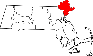 | |
| Towns | ||
| CDPs | ||
| Other villages | ||
Boston (capital) | |
| Topics |
|
| Society | |
| Regions | |
| Counties | |
| Cities |
|