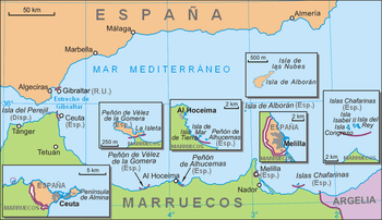
Peñón de Vélez de la Gomera
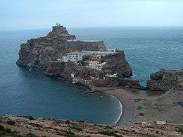
Peñón de Vélez de la Gomera (Spanish pronunciation: [peˈɲon de ˈβeleθ ðe la ɣoˈmeɾa]), in ancient times Badis or Bades, is a Spanish rock (plaza de soberanía) in the west of the Mediterranean Sea, connected to the Moroccan shore by a sandy isthmus. It is also connected to a smaller islet to the east, la Isleta, by a rocky isthmus. It is one of several peñones, or rock-fortresses, on the coast of Northern Africa. Vélez de la Gomera, along with la Isleta, are administered by the Spanish central government, and have a population consisting only of a small number of Spanish military personnel.
Geography
Peñón de Vélez de la Gomera is located 119 km southeast of Ceuta. It was a natural island in the Alboran Sea until 1934, when a huge thunderstorm washed large quantities of sand in the short channel between the island and the African continent, turning it into a tombolo.[1] Ever since, it has been a peninsula, currently connected to the Moroccan coast by an 85 m long sandy isthmus, the world's shortest single land border segment. With a length of 400 meters northwest-southeast and a width of up to 100 meters, it covers about 19,000 m² or 1.9 ha.
History

Portugal and Spain passed an agreement in 1496 in which they effectively established their zones of influence on the North African coast: Spain could only occupy territory east of Peñón de Vélez. This restriction would only end with the absorption of Portugal into the Spanish crown of Philip II after the 1578 Battle of Ksar El Kebir, when Spain started to take direct actions in Morocco, as in the occupation of Larache.[2]
In 1508, Spain launched a successful expedition under the command of Pedro Navarro to take the Peñón from the pirates who held it, and who were constantly attacking and looting the coast of Southern Spain.
In 1522, Spain lost the Peñón to a Moroccan Berber attack that resulted in the deaths of the whole Spanish garrison. Ali Abu Hassun, new ruler of the Kingdom of Fez in 1554, then gave the Peñón to Ottoman troops that had assisted him in gaining the throne.[3]
In 1564, after a failed attempt in 1563, the Spaniards under command of García Álvarez de Toledo, 4th Marquis of Villafranca retook the Peñón, killing its garrison of 150 Ottoman soldiers. Mathurin Romegas took part in the capture, and Brantôme was another witness to the event. Spain has retained control of it ever since, withstanding sieges in 1680, 1701, 1755, 1781, and 1790.
In 1871, the Spanish Congress debated abandoning the Peñón, since by that time it had lost its military role, but in the end the proposal was dropped.
On the morning of 29 August 2012 there was an incident in which seven Moroccan activists of the Committee for the Liberation of Ceuta and Melilla stormed the rock and placed flags of Morocco, resulting in Spanish soldiers arresting four of them. Among the instigators of the assault was Yahya Yahya, mayor of the Moroccan town of Beni Ansar. Three Moroccans managed to evade capture.[4]
Government
Peñón de Vélez de la Gomera is governed by direct rule from Madrid.
Transportation
The territory is reached mostly by helicopter via a helipad located on the upper sections. A landing area is located on the south end near the land entrance to Peñón de Vélez de la Gomera.
See also
References
- ↑ Historia de Peñón de Vélez de la Gomera archived from the original
- ↑ The last great Muslim empires: history of the Muslim world by Frank Ronald Charles Bagley, Hans Joachim Kissling p.103ff
- ↑ The last great Muslim empires: history of the Muslim world by Frank Ronald Charles Bagley, Hans Joachim Kissling p.103
- ↑ Staff (29 August 2012) Spanish Military Arrest Four Moroccans after they Tried to Hoist Moroccan Flag in Badis Island Morocco World Times, Retrieved 24 September 2012
External links
Countries and territories of North Africa | |||||||||||||||||||||||||||||||
|---|---|---|---|---|---|---|---|---|---|---|---|---|---|---|---|---|---|---|---|---|---|---|---|---|---|---|---|---|---|---|---|
| Sovereign states | |||||||||||||||||||||||||||||||
| Partially recognized state | |||||||||||||||||||||||||||||||
| Territories |
| ||||||||||||||||||||||||||||||
1Entirely claimed by both Morocco and the SADR. 2Spanish exclaves claimed by Morocco. 3Portuguese archipelago claimed by Spain. 4Disputed between Sudan and Egypt. 5Terra nullius located between Egypt and Sudan. 6Disputed between Sudan and South Sudan. 7Part of Chad, formerly claimed by Libya. 8Disputed between Morocco and Spain | |||||||||||||||||||||||||||||||
Coordinates: 35°10′21.29″N 4°18′2.89″W / 35.1725806°N 4.3008028°W