Pathamuttom
| Pathamuttom | |
|---|---|
| Village | |
|
Engineering College | |
| Coordinates: 9°30′43″N 76°33′1″E / 9.51194°N 76.55028°ECoordinates: 9°30′43″N 76°33′1″E / 9.51194°N 76.55028°E | |
| Country | India |
| State | Kerala |
| District | Kottayam |
| ISO 3166 code | IN-KL |
Pathamuttom is a village in Kottayam district, Kerala, India. It comes under Panachikadu Panchayath. It belongs to South Kerala Division. It is located 8 km (5.0 mi) to the south from Kottayam District headquarters, 4 km (2.5 mi) from Pallom, and 145 km (90 mi) from the state capital, Thiruvananthapuram.
Location
Kottayam , Changanassery , Thiruvalla , Alappuzha are the closest cities to Pathamuttom. Pathamuttom is located 5.5 km (3.4 mi) from Chingavanom, 5.5 km (3.4 mi) from Changanacherry, and 25.2 km (15.7 mi) from Mannar. It is also 16.6 km (10.3 mi) from Kottayam Railway Station. Also nearby Pathamuttom are the tourist centers of Kumarakom, Alleppey, Kuttanad, and Mararikulam.
Language
Malayalam is the local language here.
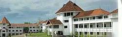
Colleges in Pathamuttom
Saintgits College of Engineering.[1]
References
- ↑ "Colleges in Pathamuttom :Saintgits". Saintgits.