Patcham
| Patcham | |
 Patcham |
|
| Population | 14,277 (2011.Ward)[1] |
|---|---|
| Unitary authority | Brighton and Hove |
| Ceremonial county | East Sussex |
| Region | South East |
| Country | England |
| Sovereign state | United Kingdom |
| Post town | BRIGHTON |
| Postcode district | BN1 |
| Dialling code | 01273 |
| Police | Sussex |
| Fire | East Sussex |
| Ambulance | South East Coast |
| EU Parliament | South East England |
| UK Parliament | Brighton Pavilion |
|
|
Coordinates: 50°51′50″N 0°09′00″W / 50.864°N 0.15°W
Patcham is an area of the city of Brighton and Hove, about 3 miles (5 km) north of the city centre. It is bounded by the A27 (Brighton bypass) to the north, Hollingbury to the east and southeast, Withdean to the south and the Brighton Main Line to the west. The A23 passes through the area.
History
Patcham was originally a separate village that developed around the partly 12th- and 13th-century All Saints church. The parish of Patcham extended to 32 square miles (83 km2) and encompassed large parts of what are now adjacent suburbs, such as Withdean, Westdene, Hollingbury and Tongdean. It extended eastwards into modern-day Moulsecoomb, westwards beyond Dyke Road into Hove, and northwards across the sparsely-populated South Downs towards the parishes of Pyecombe and Ditchling. The centre of the original village, based around the church (on Church Hill) and the Old London Road – now bypassed by the modern A23 – is a conservation area, and several buildings are listed.
Modern Patcham
Sir Herbert Carden, a prominent Brighton solicitor who was mayor for three years from 1916 and served on the council from 1895 until 1941, was responsible for the boundary changes on 1 April 1928 which brought Patcham within the "Greater Brighton" area. To commemorate this, two large stone pillars, known as the "Pylons", were erected on the A23 just north of the village of Patcham, marking the new boundary line.[2] The land around the village was mostly undeveloped at this time, but many houses were later built. Many of the estates built around the old village date from the 1930s. The Ladies Mile Estate, built around the former drove road from the village to Stanmer Park, is an example; it is separated from Hollingbury to the southeast by Carden Avenue, named after Sir Herbert.
The roads around the Mackie Avenue estate (all with Scottish names) were named by the Scottish builder George Ferguson who developed the estate. He also planted the Scots pines on the Ladies Mile Open Space.
The Windmill View estate at the top of Ladies Mile Road is built on the site of the old Patcham Fawcett School.
Patcham Community Centre. The Patcham Community Centre is run by the Patcham Community Association, which was formed in 1945. There were originally 15 groups involved, including the Patcham Communist Party, and for the first 24 years they existed without their own centre, holding meetings in the school halls in the area.
In 1969 the Patcham Fawcett High School for Boys, at the top of Ladies Mile Road, and the Margaret Hardy High School for Girls, in Warmdene Road, were relocated from central Brighton to Patcham. Fawcett had new buildings at the upper end of Ladies Mile Road, while Margaret Hardy was housed in classrooms previously used by Patcham High School. Patcham First School, at the time housed in the southern part of what is now the Patcham Junior School building, relocated to brand new buildings in Highview Avenue North, permitting expansion of the junior school (briefly Patcham Middle School in the 1970s).
At the same time Alderman Kippin (known as 'Mr Patcham') arranged for a combined community centre and youth club, each with its own suite of rooms but sharing a kitchen, to be included in the basement of a new wing of the Margaret Hardy school.
The 1989 merger of Fawcett and Margaret Hardy into Patcham High brought the boys and girls together on Warmdene Road. As more space was needed, in 2003 a PFI project overhauled the school buildings and a new Community Building erected just outside the High school grounds to incorporate both the community centre and the community library.
The new centre is now a hub of activity for local people, with over 40 different organisations using it, in addition to hosting many family celebrations.[3]
Places of interest in Patcham
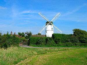
Patcham Mill is a converted windmill on high ground west of the old village (but within the former Patcham parish). Also known as Waterhall Mill and locally as Westdene Mill, it was built in 1885 and was used for 40 years. A second mill, now demolished, stood on a site near Overhill Drive and is commemorated by the street name Old Mill Close. Patcham mill on Sussex Mills website
Patcham Place (Photo) was the city's Youth Hostel until September 2007. It is in the old village centre opposite the post office, in a large area of open parkland. Below it the Brighton Main Line runs through the 492-yard (450 m) Patcham Tunnel. The house dates from 1558 and was originally the seat of the Shelley family. It later belonged to the Stapley family – Anthony Stapley played a leading part in the Civil War, being Governor of Chichester and a Regicide.
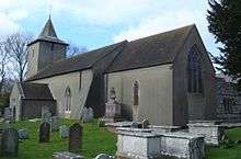
All Saints Church (website) is one of the city of Brighton and Hove's oldest churches, and is still a lively community of people. A church was recorded on this site in the Domesday Book. The churchyard includes an interesting gravestone marked with a pirate skull and crossbones motif. Close to the church stand an ancient dovecot and a converted tithe barn.
Transport
Brighton & Hove Bus and Coach Company runs routes 5, 5A and N5 (from Hangleton via the city centre) which do a circular tour of the eastern side of Patcham. Route 5A goes through the centre of the old village, while Route 5 deviates onto Carden Avenue, and the N5 goes along the 5b route after serving Patcham. Both of the 5 and 5A routes have a 20-minute daytime frequency. The N5 is hourly between 1:00 am and 4:00 am (Thursday to Saturday).
Compass Travel run the hourly Route 56: this starts in the village centre and passes through the Ladies Mile Estate en route to Hollingbury Asda, the City Centre and the Knoll Estate in Hove.
Some other services stop on the A23 outside the Black Lion pub near the Youth Hostel:
- Countryliner Coaches buses have gone into administration, so the outlook for their routes is uncertain: they ran route 40/40X (Brighton county hospital to Cuckfield, Mondays to Sunday) route 33 (to Haywards Heath via Hassocks Monday to Friday)
- Metrobus routes 270 (to East Grinstead Monday to Saturdays), 271 (to Haywards Heath via Burgess Hill Monday to Saturdays), 273 (to Crawley, Mondays to Saturdays)
- Stagecoach Group plc(Mondays to Saturdays), Compass Travel (Sundays) route 17 to Horsham
After the Second World War, Patcham was served by Brighton Hove & District Transport with bus routes 5 and 5b running jointly every 7 or 8 minutes from Brighton via the London Road to Carden Avenue, Winfield Avenue, The Ladies Mile (Clock Tower) and Mackie Avenue. Route 15 operated every 20 minutes from Brighton via the London Road to Carden Avenue, Winfield Avenue, The Ladies Mile (Clock Tower) and Barrhill Avenue to Braeside Avenue(The Deeside). Route 15b operated every 20 minutes from Brighton via London Road to Patcham Fountain, Patcham Old Village, Ladies Mile Road to The Ladies Mile (Clock Tower).
References
- ↑ "Brighton and Hove ward population 2011". Retrieved 13 October 2015.
- ↑ "Stone Pylons on the A23". My Brighton And Hove. Retrieved 5 May 2013.
- ↑ "Patcham Community Centre". Retrieved 5 May 2013.