Passenger information system
A passenger information [display] system (PIS or PIDS) is an electronic information system which provides real-time passenger information. It may include both predictions about arrival and departure times, as well as information about the nature and causes of disruptions. It may be used both physically within a transportation hub and remotely using a web browser or mobile device.
Systems


Current operational information on service running is collected from automatic vehicle location systems and from control systems, including incident capture systems. This information can be compared by computers with the published service timetable to generate a prediction of how services will run in the next few minutes to hours.
This may be informed by additional information: for instance, bus services will be affected by congestion on the road network, while all services may be affected by adverse weather conditions.
The capital and revenue costs for traveller information systems can be calculated with reasonable accuracy. However, the derivation of tangible financial benefits is far more difficult to establish and as a consequence, there is very little research. This directs the business model for information systems towards the "softer" merits such as traveller confidence etc. It is worth noting that there must be an actual value as individuals are willing to pay for systems that give them access to real time data relating to their journey. The difficulty is establishing what this is for each individual person and perhaps each individual piece of roadside hardware.
Channels
Information may be delivered via any electronic media, including:
- telephone (either a manned bureau service or an automated answering system)
- touch screen kiosks for self-service (e.g. in customer offices)
- Internet through a website
- PDA or mobile phone (typically using SMS or WAP)
- LED displays and screens inside stations
Additional considerations include:
- How the system will present information for disabled travellers
- Whether the system will be able to provide information in multiple languages
Information

The information provided by a passenger information system depends on its location, and the technical scope (e.g. how big the display screen is)
At a station or stop, it is normal to provide up to date predictions of:
- Which service is operated by the next vehicle to arrive, including its route and destination.
- When this vehicle will arrive
- How closely it is running to timetable.
- Similar information for the following few services.
- General advice on current travel disruptions that may be useful to the passenger in understanding the implications for their travel plans.
On a vehicle, it is normal to provide up to date predictions of:
- The next station or stop.
- When it will arrive.
- How closely it is running to timetable.
- Advice on connecting services.
Personalised channels (web, mobile device, or kiosk) will normally be set up to mimic the view from a station or stop but may in addition be linked to journey planners. Using such systems a passenger may (re)plan their journey to take into account current circumstances (such as cancelled services or excessive delays).
Examples
France
In Paris, France, SIEL indicator systems (abbreviated from Système d’information en ligne) are installed in the RER, the Paris Métro and on 250 bus routes on the RATP bus system.
On the RER, there are 2 types of indicators used, the first generation model which only indicates the termini of trains stopping at a station through the use of square lights located beside the words bearing the name of a terminus, and the second generation model which includes an LED display above the square lights indicating the terminus and train service. These displays are only used on the RER line A, RER line B and at Gare de Châtelet – Les Halles station on RER line D, and can be inaccurate at times due to the lack of communication between SNCF and RATP, the two operators of the RER.
On the Paris Métro, there are two types of information display systems; the LED numerical display installed in all Métro lines (except line 14), in use since 1997, and the television display installed on all stations on line 14. These displays show the time needed for a train (and the subsequent train after it) to reach a particular station.
On the bus network in Paris, monochrome LCDs have been used since 1996 to indicate the time needed for a bus on a bus route to arrive at a bus stop, after a two-year trial period on a few bus routes.
-
.jpg)
1st generation termini indicator on the RER line A
-

2nd generation termini indicator on the RER line B
-

LED indicator on the Paris Métro
-

A variant of the Métro's LED indicator used on Paris Métro Line 13 utilizing a lighted arrow indicating the terminus of the next train
-

TV screen used on Paris Métro Line 14
-

LCD used on Paris's bus system
Germany
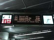
Deutsche Bahn AG offers a Travel Information System (RIS). This shows current train times compared to the published timetable, as well as known delays and expected arrival and departure times of the trains.
This information is made available to the train conductor (via SMS) as well as to the passenger via loudspeaker in the train station or schedule boards on the internet.[1] The VRR[2] and VRS[3] transportation schedule information systems also process RIS data.
The data can also be queried in real-time via mobile terminal devices like PDAs, and mobile phones over WAP and i-mode.
- WAP: http://wap.bahn.de/bin/mobil/bhftafel.exe/dow?
- imode: http://wap.bahn.de/bin/mobil/bhftafel.exe/doi?
- PDA: http://reiseauskunft.bahn.de/bin/bhftafel.exe/dn?L=ua_pda&
United Kingdom
National Rail stations are equipped with visual platform displays which indicate the next service or services from the platform, and which warn passengers to stand clear of trains which are not scheduled to stop, which are not in use, or which are about to depart. Audio announcements are made to confirm these. Additionally, concourses and ticket offices have large screen displays which show all of the services available at the station for the next hour or more, and (at major stations) the full route of the service and any restrictions applicable (e.g. ticket types, catering services, bicycle carriage). It should be noted that many smaller and less well-used railway stations do not have such systems, but rather have Passenger Help Points which connect the user by telephone to a control room by pushing an "Information" button.
This information is available online at National Rail[4] and on mobile devices.
Most London Underground stations have “Countdown” displays on each platform. These are simpler than the national rail displays as in most cases each platform serves only a single line and there are little to none variations in carriage restrictions and destinations served. Audio announcements are also made regularly.
Buses are operated by local operating companies but in close partnership with local authorities. Local authorities, and some transport operators, provide electronic versions of the bus timetables to the Traveline[5] information service which covers all public transport modes, and from there to other information services such as and Transport Direct,[6] and Google Transit.[7]
The deployment of real-time bus information systems is a gradual process which currently extends to around half of the national fleet and a high proportion of town-centre stops, but relatively few suburban and rural locations.
The first sight of these system was in Brighton and Hove, where the council developed them and they were such a success that the UK government gave councils money to invest in this technology. Brighton and Hove Council provide this information in real-time. The systems are viewable from a long distance, not just in the shelter where most operate from.
The Traveline NextBuses[8] information service provides the next departures from any bus stop in the UK, and some trams as well. This information is real-time where the real-time feed has been connected in, otherwise the scheduled times are given. The convention is to show real-time information as (in x mins) and scheduled information as a time (xx.xx).
A variety of electric services are available through SMS which cover large parts of the UK’s public transport network, and many web sites provide access to information from bus or train real-time systems. Most of this is single-mode.
The Government-sponsored Transport Direct project provides journey planning across all transport modes (including private car) and is increasingly linked to real-time information systems.
Audio announcement (on or off bus) is relatively rare, although London and some metropolitan areas have recently seen significant increases.
United States

Real time passenger information was brought to riders in the US by NextBus corporation, a small startup, in 1999. The first systems were installed in Emeryville, California, and later in San Francisco, California. As of 2012 both initial systems are still in operation.
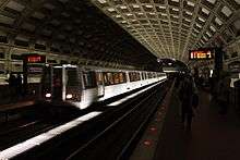
The Washington Metro installed a PIDS in all of its stations in 2000. The system provides real-time information on next train arrivals, delayed trains, emergency announcements, and related information.[9] Metro also provides current train and related information to customers with conventional web browsers, as well as users of smartphones and other mobile devices.[10] In 2010, Metro began sharing its PIDS data with outside software developers, for use in creating additional real-time applications for mobile devices. Free apps are available to the public on major mobile device software platforms (iPhone/iPad, Android, Windows Phone, Palm).[11][12] The system also began providing real-time train information by phone in 2010.[13]
The New York City Subway began installing its Public Address/Customer Information Screens, commonly known as "countdown clocks", in its stations in 2007. In 2012, the system began offering SubTime, a website and iPhone app for real-time train arrival estimates for several of its subway services,[14] and the arrival data are shared with outside software developers to support creation of additional apps.[15] There are also PIDS installed on some MTA Regional Bus Operations routes over the years, but mostly, the MTA offers real-time bus tracking through another website/app called BusTime.[16]
Amtrak has deployed PIDS throughout the Northeast Corridor. Boston MBTA and MBCR have also deployed PIDS.
As of 2010, PIDS are being deployed with unified messaging, which can include information streamed to mobile devices, phones and translated directly to voice announcements. Text to Speech products have been designed to convert PIDS data to speech in a choice of over 20 languages.
See also
- CEN Transmodel, IFOPT and SIRI: technical specifications and standards
- Dynamic Passenger Information (DPI)
- IEEE Intelligent Transportation Systems Society
- Passenger information
- Real Time Information Group
References
- ↑ "DB BAHN - Abfahrt und Ankunft". Bahn.de. Retrieved 2014-06-28.
- ↑ "Verkehrsverbund Rhein-Ruhr - Fahrten planen". Vrr.de. Retrieved 2014-06-28.
- ↑ http://195.14.241.6/ass/client/vrs/fahrplanauskunft.html
- ↑ "nationalrail.co.uk". nationalrail.co.uk. Retrieved 2014-06-28.
- ↑ "traveline.info". traveline.info. Retrieved 2014-06-28.
- ↑ "transportdirect.info". transportdirect.info. Retrieved 2014-06-28.
- ↑ "Transit – Google Maps". Google.com. Retrieved 2014-06-28.
- ↑ "Traveline - mobile phone services". Traveline.info. Retrieved 2014-06-28.
- ↑ Washington Metropolitan Area Transit Authority (WMATA) (2004-03-26). "Metro offers enhancements for the passenger information display monitors." News release.
- ↑ WMATA. "Mobile Services." Accessed 2012-11-19.
- ↑ WMATA (2010-08-06). "Metro invites software developers to discuss new transit data feed." News release.
- ↑ WMATA. "Developer Resources." Accessed 2012-11-19.
- ↑ WMATA (2010-08-31). "Real-time next train arrival information now available by phone." News release.
- ↑ http://apps.mta.info/traintime/
- ↑ Metropolitan Transportation Authority, New York (2014-01-13). "MTA Adds Real-Time Arrival Estimates on L Line." MTA News.
- ↑ http://bustime.mta.info/
External links
- DB travel information: current traffic situation
- An alternative entry form for Deutsche Bahn AG travel information
- Bus & Train explained: Guide to travel information
- UK Traveline
- UK Transport Direct
- Delfi protocol: Germany-wide passenger information from point to point