Pasadena Transit
|
| |
| Parent | Pasadena DOT |
|---|---|
| Founded | 1994 |
| Headquarters | 221 E. Walnut St, Pasadena |
| Service area | Pasadena, CA |
| Service type | bus service |
| Routes | 8 |
| Annual ridership | 1,531,527 (2012)[1] |
| Fuel type | CNG |
| Operator | First Transit |
| Website | Pasadena Transit |

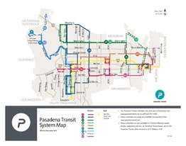
System Map (as of December 2015)
Pasadena Transit, formerly known as Pasadena Area Rapid Transit System (ARTS), is a city-operated local bus service in Pasadena, California, United States. It was formed in 1994 coinciding with the kickoff of the World Cup at the Rose Bowl as a free service of the City of Pasadena.[2] In 2003, fares were introduced. In December 2015, the agency changed its name to Pasadena Transit.[3]
Fixed-route service
Pasadena ARTS consists of 8 routes in the City of Pasadena. All routes connect with the Metro Gold Line.[4]
Route overview
| Route | Direction | Terminals | via | Days of Operation [lower-alpha 1] | Schedule Information | |
|---|---|---|---|---|---|---|
| Westbound / Northbound | Eastbound / Southbound | |||||
10 |
West / East | Old Pasadena Green Street and Orange Grove Boulevard |
Allen Station | Green Street, Del Mar Boulevard, Allen Street, Colorado Boulevard | Weekdays, Saturdays | Schedule |
20 |
Clockwise / Counter-clockwise | Altadena [lower-alpha 2] Fair Oaks Avenue and Woodbury Road |
Woodbury Road, Lake Avenue, California Boulevard, Fair Oaks Avenue | Weekdays, Saturdays | Schedule | |
31 |
West / East | Altadena Fair Oaks Avenue and Woodbury Road |
Sierra Madre Villa Station | Washington Boulevard, Altadena Drive | Weekdays, Saturdays | Schedule |
| 32 | Washington Boulevard, New York Avenue | |||||
40 |
West / East | Old Pasadena Raymond Street and Holly Street |
Sierra Madre Villa Station | Villa Street, Orange Grove Boulevard, Rosemead Boulevard | Weekdays, Saturdays | Schedule |
51 |
North / South | Art Center College of Design North Campus |
Fillmore Station | Fiar Oaks Avenue, Raymond Avenue, Seco Street, Linda Vista Street | Weekdays | Schedule |
| Rose Bowl | Memorial Park Station | Fiar Oaks Avenue, Raymond Avenue, Seco Street | Saturdays | |||
52 |
North [lower-alpha 3] | Art Center College of Design / JPL [lower-alpha 3] | N/A | Fair Oaks Avenue, Raymond Avenue, Seco Street, Oak Grove Drive | Weekdays peak periods [lower-alpha 4] | Schedule |
60 |
West / East | Pasadena City College | Hastings Ranch Sierra Madre Boulevard and Michillinda Avenue |
Del Mar Boulevard, San Gabriel Boulevard, Foothill Boulevard | Weekdays peak periods | Schedule |
Notes
- ↑ No service is provided on Sundays, New Year’s Day, Memorial Day, Independence Day, Labor Day, Thanksgiving Day, and Christmas Day.
- ↑ All counterclockwise buses will recover at Woodbury Road & Raymond Lane for several minutes before proceeding to Fair Oaks Avenue and Woodbury Road.
- 1 2 Route 52 runs north form Fillmore Station to Jet Propulsion Laboratory, then turn south to Art Center. The bus will stop at the Art Center terminal for 6 - 7 minutes, then continues as southbound Route 51 back to Fillmore Station.
- ↑ Route 52 operates 1 am trip and 2 pm trips during weekdays.
Fares
| Fare Type † | Regular | Student ‡ | Senior (62+) / Disabled / Medicare ‡ |
|---|---|---|---|
| One-way | $0.75 | $0.50 | $0.35 |
| Local Transfer | Free | ||
| Interagency Transfer | $0.25 | $0.10 | |
- TAP is now accepted aboard all Pasadena Transit buses.
- † children five years of age and under may ride free (maximum 2 children w/ accompanying adult).
- ‡ Proper identification must be presented to obtain the reduced Student and Senior/Disabled/Medicare fare.
- Inter-agency paper transfers are used to transfer to Metro and Foothill Transit buses, TAP (Transit Access Pass) card transfers are used to transfer to Metro Gold Line only.
Future Development
The Pasadena-Altadena Regional Trolley System is a recently proposed heritage streetcar system that would connect Altadena, Downtown, and Pasadena City College. No dates for this proposal have been set.[5]
References
- ↑ Maps & Reports. Pasadena DOT http://cityofpasadena.net/WorkArea/DownloadAsset.aspx?id=6442470680. Retrieved 22 February 2016. Missing or empty
|title=(help) - ↑ public transit in pasadena
- ↑ Miller, Terry (December 1, 2015). "ARTS Bus in Pasadena Morphs into Pasadena Transit". Pasadena Independent. Retrieved December 11, 2015.
- ↑ City of Montebello - Bus Lines, City of Montebello, retrieved April 30, 2015
- ↑ Thal Armathura. "Avenue to the Sky - Lake Avenue, Pasadena".
See also
This article is issued from Wikipedia - version of the 2/22/2016. The text is available under the Creative Commons Attribution/Share Alike but additional terms may apply for the media files.