Park Royal tube station
| Park Royal | |
|---|---|
 | |
 Park Royal Location of Park Royal in Greater London | |
| Location | Park Royal |
| Local authority | London Borough of Ealing |
| Managed by | London Underground |
| Number of platforms | 2 |
| Fare zone | 3 |
| OSI | Hanger Lane [1] |
| London Underground annual entry and exit | |
| 2012 |
|
| 2013 |
|
| 2014 |
|
| 2015 |
|
| Railway companies | |
| Original company | District Railway |
| Key dates | |
| 6 July 1931 | Station opened as Park Royal |
| 4 July 1932 | District line service replaced by Piccadilly line |
| 1 March 1936 | Renamed Park Royal (Hanger Hill) |
| 1947 | Renamed Park Royal |
| Listed status | |
| Listing grade | II |
| Entry number | 1079328[3] |
| Added to list | 15 October 1987 |
| Other information | |
| Lists of stations | |
| WGS84 | 51°31′37″N 0°17′03″W / 51.5269°N 0.2842°WCoordinates: 51°31′37″N 0°17′03″W / 51.5269°N 0.2842°W |
|
| |
Park Royal is a station on the Piccadilly line of the London Underground. It is between North Ealing and Alperton and is in Travelcard Zone 3. It is situated on the south side of the east-west Western Avenue (A40), surrounded by residential Ealing and industrial Park Royal. There is a pedestrian subway under the A40 road near the station.
The station's platforms have a continuous significant gradient (sloping up from south to north).[4]
History
The District Railway (DR, now the District line) opened the line through Park Royal on its new extension to South Harrow on 23 June 1903.[5] A station, Park Royal & Twyford Abbey, was opened at that time a short distance to the north of the current station to serve the Royal Agricultural Society's recently opened Park Royal show grounds.
The current station was built for the extension of Piccadilly line services over the District line tracks to South Harrow. It opened on 6 July 1931 and replaced the earlier station which closed on the previous day.[5]
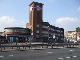
First opened as a temporary timber structure, the current station building was designed by Welch & Lander in an Art Deco/Streamline Moderne style influenced by the Underground's principal architect Charles Holden. The station buildings are formed from a series of simple interconnecting geometric shapes. Plain red brick masses are accented with strong horizontal and vertical glazed elements. A large circular ticket hall with high level windows gives access to the platform stairs. The enclosures for these form cascades of glazed steps down to the platforms. The most prominent feature of the station building is the tall square tower adjacent to the ticket hall. This is adorned with the Underground roundel; and represents a visible locator for the station from some distance. The permanent structure was opened in 1936. Attached to the station building and across the small open space of Hanger Green are two curved three-storey retail and office buildings built in the same style as the station.
On 4 July 1932, the Piccadilly line was extended to run west of its original terminus at Hammersmith sharing the route with the District line to Ealing Common. From Ealing Common to South Harrow, the District line was replaced by the Piccadilly line.[5]
From 1 March 1936 until 1947 the station name was modified to Park Royal (Hanger Hill).[5] The suffix was then dropped and the station returned to the unmodified version. Hanger Hill referred to a residential estate adjacent to the station.
Possible development
The Mayor's plans for the area include improvements to the station access.[6]
The developers of the First Central business park at Park Royal were planning a new station between North Acton and Hanger Lane on the Central line. This would have served the business park and provide a walking distance interchange with Park Royal station.[7] This is not being actively pursued. London Underground has said that the transport benefits of a Park Royal station on the Central line are not sufficiently high to justify the costs of construction.[8]
Services
The off-peak service in trains per hour (tph) is:[9]
- 6tph to Cockfosters (Eastbound)
- 3tph to Rayners Lane (Westbound)
- 3tph to Uxbridge via Rayners Lane (Westbound)
The peak time service in trains per hour (tph) is:[10]
- 12tph to Cockfosters (Eastbound)
- 6tph to Rayners Lane (Westbound)
- 6tph to Uxbridge via Rayners Lane (Westbound)
Connections
London Buses routes 95 and 487 serve the station.
Gallery
| Wikimedia Commons has media related to Park Royal tube station. |
 Looking north from the eastbound platform (in the westbound direction)
 Looking south from the eastbound platform (in the eastbound direction)
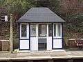 Platform shelter on the westbound platform - note slope of platform from south to north
References
- ↑ "Out of Station Interchanges" (XLS). Transport for London. May 2011. Archived from the original on 20 October 2012.
- 1 2 3 4 "Multi-year station entry-and-exit figures" (XLS). London Underground station passenger usage data. Transport for London. April 2016. Retrieved 3 May 2016.
- ↑ Historic England. "Details from listed building database (1079328)". National Heritage List for England. Retrieved 29 September 2015.
- ↑ "Transport Plans for the London Area: West". See How They Run. Retrieved 20 May 2012.
- 1 2 3 4 Rose, Douglas (1999). The London Underground, A Diagrammatic History. Douglas Rose/Capital Transport. ISBN 1-85414-219-4.
- ↑ "Park Royal Opportunity Area Planning Framework" (PDF). Greater London Authority. pp. 103, 107. Archived from the original (PDF) on 26 September 2013.
|chapter=ignored (help) - ↑ First Central Business Park.
- ↑ "Proposed Park Royal Central Line station" (PDF). 20 October 2009. Retrieved 21 May 2012.
- ↑ http://content.tfl.gov.uk/wtt-56-piccadilly.pdf
- ↑ http://content.tfl.gov.uk/wtt-56-piccadilly.pdf
External links
| Wikimedia Commons has media related to Park Royal tube station. |
- London Transport Museum Photographic Archive
- Temporary station, 1934
- Ticket Hall in 1939
- Station and attached shops, 1948
- Park Royal Station, looking underneath the A40 road bridge from the eastbound platform, 2000. A new footpath would have passed under the road on the right, to reach the proposed Central line platforms (which are unlikely to be built)
- External view of station, showing ticket hall and tower, 2001
- First Central Business Park
- More photographs of this station
| Preceding station | Following station | |||
|---|---|---|---|---|
| Piccadilly line | towards Cockfosters |
|||
| Former services | ||||
| Preceding station | Following station | |||
| District line (1931–1932) | towards Upminster |
|||
| Stations | |||||||||||||||
|---|---|---|---|---|---|---|---|---|---|---|---|---|---|---|---|
| Rolling stock |
| ||||||||||||||
| History |
| ||||||||||||||
| |||||||||||||||
| Stations |
| ||||||||||||||||||||||||
|---|---|---|---|---|---|---|---|---|---|---|---|---|---|---|---|---|---|---|---|---|---|---|---|---|---|
| Rolling stock | |||||||||||||||||||||||||
| History |
| ||||||||||||||||||||||||
| Proposed stations | |||||||||||||||||||||||||
| Depots | |||||||||||||||||||||||||
| |||||||||||||||||||||||||