Parikud
| Parikud "ପାରିକୁଦ" | |
|---|---|
| Rural Island | |
 Parikud Location in Odisha, India | |
| Coordinates: 19°35′36″N 85°19′08″E / 19.593313°N 85.318950°ECoordinates: 19°35′36″N 85°19′08″E / 19.593313°N 85.318950°E | |
| Country |
|
| State | Odisha |
| District | Puri |
| Government | |
| • MLA | Sanjay Kumar Das Burma (BJD) |
| • BDO | Bhaskar Raito, BDO, Krushnaprasad |
| Elevation | 1 m (3 ft) |
| Population (2011) | |
| • Total | 89,371 |
| Languages | |
| • Official | Odia |
| Time zone | IST (UTC+5:30) |
| PIN | 752032 |
| Website |
www |
Parikud (Odia : "ପାରିକୁଦ") is an island within the Chilika lake. The land mass is spread over 96 Mouzas of Krishnaprasad Panchayat Samiti. It is surrounded by Chilika Lake and the Bay of Bengal in its two sides. Jahnikuda is present at the eastern most position of the island near Chilika lake. Jahnikuda act as a gateway to Puri, the land of lord Jagannath. The people living in this area are mainly dependent on cultivation and fishing.
Geography
Parikud is located at 19°35′N 85°19′E / 19.59°N 85.31°E. It is surrounded by Bay of Bengal in south-east and Chilika lake in north-west
Communication
Malud, a premier bazar in Parikud is 23 km from NH5.
History[1][2][3]
Before 1774, Parikud was under the king of Bankad (now Banpur). As Bankara was always attacked by east India Company, Raja of Bankad Sri Harisevak Mansingh first came to Parikud and established his capital known as Nrusinghgarh at Gurubai. Finally Raja Bhagirathi Mansingh shifted his capital to Krishnaprasad and erected the royal palace in the year 1798. British rulers could not attack Parikud due to its location for many years as the region was covered with Chilika lake. There is a folktale suggesting that a milkman who informed the king about the crane killing an eagle, the king was fascinated to shift his capital to Krishnaprasad. The king also donated a village for Brahmins (sasan) which is known as Bhagirathipur Sasan.
When the British invaded Odisha from the south in 1803, the traitor Fateh Muhammed, a ferry owner from Kandakhai (Malud) met them on the shores of Chilika. He showed them the eastern route, by which they managed to reach Puri undetected. In, return, Fateh Muhammed was given freehold of the areas of Malud and Parikud, most of which is today called Garh Krishnaprasad block.
Demographics
As of 2011 India census,[4] Krishnaprasad Block had a population of 89,371. Males constitute 51% of the population and females 49%. Parikud has an average literacy rate of 72.24%, very close to the national average of 74.04%; with 78% of the males and 65% of females literate.
96 Mouzas(revenue villages)[5] of Parikud regions are given below.
- Alanda
- Deulapada
- Sanaanla
- Nalitakudi
- Siandi
- Barunakuda
- Harichandanpur
- Gobardhuli
- Talangiri
- Udayagira
- Jamuna
- Badaanla
- Ipinga
- Naba
- Gopalpur
- Berhumpur
- Balijagannathpur
- Sipia
- Kumarpur
- Talatala
- Tichhini
- Khalamuhan
- Maladeikuda
- Fatepur
- Ora
- Maensa
- Kamalasingh
- Mardarajpur
- Samantarapur
- Rasidgaon
- Chitrakote
- Uthanikuda
- Kalijaipahad
- Adalabad
- Anua
- Parala
- Baripadar
- Kurupal
- Ramalenka
- Kandeswar
- Alanda Patana
- Badadanda
- Nalabana
- Siala
- Nolipatana
- Bhabanipur
- Badajhad
- Patanasi
- Nandala
- Pitisal
- Titipa
- Rasakudi
- Budhibar
- Kanheipur
- Nuapada
- Khirisahi
- Jenapur
- Paikerapur
- Balipatapur
- Baliapokhari
- Nuagaon
- Jagirikuda
- Sahabajpur
- Kumpuri
- Anlakuda
- Mithakuan
- Goursi
- Kadakani
- Hunjan
- Chadheya
- Kandaragaon
- Kholaganja
- Morada
- Gurubai
- Gomundia
- Jharakata
- Malakuda
- Brahmandeo
- Fulabari
- Khatiakudi
- Patharaganja
- Nuagaon
- Janhikuda
- Tubuka
- Patharakata
- Arakhakuda
- Patanasi
- Kalada
- Krushnaprasad
- Maludakhas
- Gilinasi
- Khatisahi
- Santarapur
- Golapur
- Badakuda
- Bajrakote
- Patapur
Climate
As the region is situated in the coastal area there you cannot feel too hot in summer or too cold in winter. The rain fall is sound and suitable for agriculture.
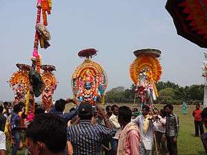
Art and Culture
As in Oriya proverb bara masa tera parva 13 festival in 12 months. Here in Parikud you can find such culture also. Famous festival celebrated in Parikud are:
- Pana Yatra
- Panchudola Yatra
- Dasadola Yatra
- Chandan Yatra
- Raja Parba
- Kartika Purnima
- Dola Purnima
- Makar Sankranti
- Maha Shivaratri
- Durga Puja
- Dussehra
- Diwali
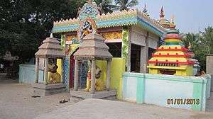
Famous temples in Parikud are:[6]
- Baba Jagateswar Temple - Naba
- Pandeswar Dev – Titipo
- Kamaleswar Dev – Daulapada
- Sarveswar Dev – Mahisa
- Jhadeswar Dev – Badajharo
- Balingaswar Dev – Golopuru
- Bateswar Dev – Gomundia
- Gopinath Dev – Balisasano
- Guteswar Dev- Nuapada
- Dadhibaban Dev-Gurubai
- Radhakanta Dev- Janhikuda
- Nilakantheswar Dev – Krushnaprasad
- Dadhibaban Dev – Krushnaprasad
- Shree Jagananth Temple – Krushnaprasad
- Nilakantheswar Dev – Olanda
- Bateswar Dev – Moroda
- Dadhibaban Dev-Siala
- Jagateswar Deva – Ciyandi
- Maa Kanak Durga Devi –Krushnaprasad
- Maa Charchika Devi – Nuapada
- Baba Akhandaleswar Dev- Patapur/Gopalpur/Ratamati
- Maa Chandidevi-Patapur
Education
There are many primary schools and high schools in the region. Some of the best high schools are as follows-
- Mayadhar Mansingh memorial high school, Nadala.
- Malud high school, Malud.
- Gopinath dev bidyapith, Balijagannathpur.
- Tichhini high school, Tichhini.
- Parikud Lakshman Chandra bidyapith, Krushnaprasad.
Parikud has three colleges and they are:
- Kandakhai College of Science and Arts, Bajrokote
- Rukmunidevi Chilika Mahavidyalaya, Chilika Nuapada
- Women's College, Titipa
Health and Community Centre
There is a primary health center at Chilika Nuapada.
Politics
Parikud comes under Brahmagiri (Sl. No.: 108), a Vidhan Sabha constituency of Puri district, Odisha. In 2014 election, Biju Janata Dal candidate Sanjay Kumar Das Burma defeated Indian National Congress candidate Lalatendu Bidyadhar Mohapatra.
Notable Personalities
- Mayadhar Mansingh - Odia poet and writer
- Lalit Mansingh - Former Indian diplomat, the Foreign Secretary of India
- Udayanath Jena - Titipa - popularly known as Chilika Gandhi
- Sanjay Kumar Das Burma - MLA, Brahmagiri
- Lalatendu Bidyadhar Mohapatra - Former MLA, Brahmagiri
- Ajaya Kumar Jena - Former MLA
See also
References
- ↑ http://odisha.gov.in/e-magazine/Orissareview/2009/Jan/engpdf/47-49.pdf
- ↑ "Santosh Chandra Deo: Leader of Mass". santoshchandradeo.com. Retrieved 2016-02-19.
- ↑ "History | Chilika Development Authority". www.chilika.com. Retrieved 2016-02-19.
- ↑ http://censusindia.gov.in/pca/cdb_pca_census/PCA%20CDB-2118-F-Census.xlsx
- ↑ http://ordistportalcontent.nic.in/storeddata/document/vill_list/ORIPRI_VILLAGE_LIST_6666.pdf
- ↑ "Santosh Chandra Deo: Leader of Mass". santoshchandradeo.com. Retrieved 2016-02-19.