Pardines, Girona
| Pardines | |||
|---|---|---|---|
| Municipality | |||
 | |||
| |||
 | |||
| Coordinates: 42°18′49″N 2°12′55″E / 42.31361°N 2.21528°ECoordinates: 42°18′49″N 2°12′55″E / 42.31361°N 2.21528°E | |||
| Country |
| ||
| Autonomous Community |
| ||
| Province | Girona | ||
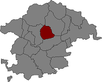
| Comarca | Ripollès | ||
| Government | |||
| • Mayor | Núria Pérez Desel (2015)[1] | ||
| Area[2] | |||
| • Total | 31.0 km2 (12.0 sq mi) | ||
| Elevation | 1,226 m (4,022 ft) | ||
| Population (2014)[1] | |||
| • Total | 155 | ||
| • Density | 5.0/km2 (13/sq mi) | ||
| Website |
www | ||


Sant Esteve
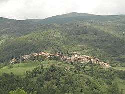
Pardines (Catalan pronunciation: [pərˈðinəs]) is a municipality in the comarca of Ripollès, province of Girona, Catalonia, Spain.
The highest point in the municipality is Puig Cerverís (2,202 m). The municipality is bordered on the north by Queralbs and Vilallonga de Ter, on the east and south by Ogassa, and on the west by Ribes de Freser and Queralbs.
History
The name Pardines has its origins in the name parietinas, which means "building ruins." It is first documented in 839, in the act of consecration of Sant Ot d'Urgell. It was a possession of the counts of Cerdanya, the nobility of Sales, the monastery of Sant Martí de Canigó, and the counts of Barcelona.
Demographic evolution
| 1900 | 1930 | 1950 | 1970 | 1981 | 1986 | 2006 |
|---|---|---|---|---|---|---|
| 476 | 448 | 357 | 193 | 130 | 118 | 149 |
Sights
- Church of Santa Magdalena
- Church of Sant Esteve
- Chapel of Santa Magdalena
- Chapel of Sant Martí
- Chapel of the Roser
References
- 1 2 "Ajuntament de Pardines". Generalitat of Catalonia. Retrieved 2015-11-13.
- ↑ "El municipi en xifres: Pardines". Statistical Institute of Catalonia. Retrieved 2015-11-23.
- Panareda Clopés, Josep Maria; Rios Calvet, Jaume; Rabella Vives, Josep Maria (1989). Guia de Catalunya, Barcelona:Caixa de Catalunya. ISBN 84-87135-01-3 (Spanish). ISBN 84-87135-02-1 (Catalan).
External links
- Information from the Generalitat de Catalunya
- Information from the Institut d'Estadística de Catalunya
 |
Queralbs | | ||
| Ribes de Freser | |
Vilallonga de Ter | ||
| ||||
| | ||||
| Ogassa |
Municipalities of Ripollès | ||
|---|---|---|
This article is issued from Wikipedia - version of the 1/25/2016. The text is available under the Creative Commons Attribution/Share Alike but additional terms may apply for the media files.