Paranaguá
| Paranaguá | |||
|---|---|---|---|
| Municipality | |||
| Município de Paranaguá Municipality of Paranaguá | |||
|
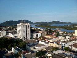
Ilha da Cotinga as seen from the top of the Palácio do Café | |||
| |||
|
Nickname(s): Berço da civilização paranaense Mãe do Paraná Grande mar redondo | |||
 Location of Paranaguá in Paraná | |||
 Paranaguá Location in Brazil | |||
| Coordinates: 25°31′15″S 48°30′34″W / 25.52083°S 48.50944°WCoordinates: 25°31′15″S 48°30′34″W / 25.52083°S 48.50944°W | |||
| Country |
| ||
| Region | South | ||
| State |
| ||
| Founded | July 29, 1648 | ||
| Government | |||
| • Mayor |
Edison Kersten (2013–2016) | ||
| Area | |||
| • Total | 826.674 km2 (319.181 sq mi) | ||
| Elevation | 5 m (16 ft) | ||
| Population (2013) | |||
| • Total | 148,232 | ||
| • Metro density | 169.92/km2 (440.1/sq mi) | ||
| [1] | |||
| Demonym(s) | Parnanguara | ||
| Time zone | BRT (UTC−3) | ||
| • Summer (DST) | BRST (UTC−2) | ||
| [1] | |||

Paranaguá (Great Round Sea, in Tupi) is a city in the state of Paraná in Brazil. Founded in 1648, it is Paraná's oldest city. It is known for the Port of Paraná, which serves as both the sea link for Curitiba, 110 kilometres (68 mi) to the north and the capital of Paraná, and as one of the largest ports of Brazil.[2]
As of 2013, the city has an estimated population of 148,232 and a population density of 169.92 persons per km², making it the tenth most populated city in the state of Paraná. The total area of the city is 826.674 km2 (319.18 sq mi).[1] The Human Development Index in 2000 was 0.782.
Conservation
The municipality contains 4% of the 199,587 hectares (493,190 acres) Guaratuba Environmental Protection Area, created in 1992.[3] It holds 17% of the 34,179 hectares (84,460 acres) Bom Jesus Biological Reserve, a strictly protected conservation unit established in 2012.[4] The municipality contains the Ilha do Mel State Park and the Ilha do Mel Ecological Station on the 2,760 hectares (6,800 acres) Ilha do Mel (Honey Island) at the mouth of Paranaguá Bay.[5]
History
Early settlement
Paranaguá was home to a sambaqui, or midden culture, for several millenia prior to the arrival of the Portuguese. Little is known of the population, which existed along the coast of Paraná. The area was later home to the Carijó people, an extinct subgroup of the Guaraní people. Portuguese explorers captured the Carijó for slave labor. Over time, the remaining Carijó intermarried with whites and African residents and formed the Caiçaras subgroup.[6]
European settlement
The Paraná coastline was already known and inhabited by the Europeans as early as 1549. Settlements in the area were first noted by the German Hans Staden (c. 1525 – c. 1579), who was shipwrecked in the area of 1578. Staden described the existence of a small chapel dedicated to Nossa Senhora do Rosário (Our Lady of the Rosary). Diogo Unhate, notary (tabelião) of Captaincy of São Vicente, obtained the first land grant in Paraná in 1614. Unhate was granted the lands between the Ararapira River and Superagui rivers. Gabriel de Lara, who has passed into history as the "captain settler" arrived in Paranaguá in 1640. He erected the first pillory in the area on January 6, 1646, the ultimate symbol of justice and power of the Portuguese. Lara announced the discovery of gold in Paranaguá in the same year. The Portuguese established the municipality of Paranugua by Royal Charter on July 29, 1648, and the city has the distinction of being the first settlement formally founded in the state of Paraná.[6]
Port of Paranaguá
The economy of the city is driven by the deepwater Port of Paranaguá, which dates to the 16th century. The port was a point of entry for the settlement of the south of Brazil beginning early in the colonial period. It exports the largest volume of agricultural products of any of the ports of Brazil, notably of grain grown in the southern regions of the country. The port is also a major trade center of automobiles, fertilizer, lumber, paper, petroleum products, salt, soy beans, and sugar. It is administered by the Port Administration of Paranaguá and Antonina (Administração dos Portos de Paranaguá e Antonina), which was created by the state of Paraná in 1947.[2]
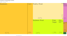
In 2014, Paranaguá was the 7th largest exporting city, by value, in Brazil. The total value of exported goods that year were $4.3B (USD).[7] The top three products exported by the municipality were soybeans (41% of total exports), poultry meat (22%), and soybean meal (14%).[8][9]
Climate
Although Paranaguá is situated in the southern part of Brazil, where temperatures are cooler, it is known for its very sultry summers and relatively mild winters.
Summer
Paranaguá is one of Paraná's hottest cities in the summer. Temperatures above 35 °C (95 °F) happen rather frequently from January through early March, but rarely reaching 40 °C (104 °F).
Winter
The coolest month of the year is usually July, with average highs of 21-22 °C and lows of around 13 °C (55 °F). After the passage of cold fronts, temperatures usually dip below 10 °C (50 °F), but very rarely below 5 °C (41 °F).
Sports
Rio Branco Sport Club is the city football club. In 2006, the club disputed the Campeonato Brasileiro Série C. Estádio da Estradinha is the city stadium.
Transportation
Air
Paranaguá is served by Paranaguá Airport, a small general aviation airport. The closest international airport to the city is Afonso Pena International Airport in São José dos Pinhais, which is directly adjacent to Curitiba.[10]
Sister Cities
Paranaguá is sister cities with:
References
- 1 2 3 "O Cidades: Paraná-Paranaguá" (in Portuguese). Rio de Janeiro, Brazil: Instituto Brasileiro de Geografia e Estatística (IBGE). 2014. Retrieved 2014-04-24.
- 1 2 "Port of Paranagá". Paranaguá, PR, Brazil: Administração dos Portos de Paranaguá e Antonina - APPA. 2014. Retrieved 2014-04-26.
- ↑ APA Guaratuba (in Portuguese), ISA: Instituto Socioambiental, retrieved 2016-11-19
- ↑ REBIO Bom Jesus – ISA.
- ↑ Contextualização do Parque Estadual da Ilha do Mel 2011, p. 1.2.
- 1 2 "A Cidade: História" (in Portuguese). Paranaguá, Brazil: Prefeitura Municipal de Paranaguá. 2016. Retrieved 2016-08-15.
- ↑ DataViva. "Brazilian International Trade by Municipality (2014)", DataViva. Retrieved June 24, 2015.
- ↑ DataViva. "International Trade Data for Paranaguá (2014)", DataViva. Retrieved June 24, 2015.
- ↑ DataViva. "Exports of Paranaguá (2014)", DataViva. Retrieved June 24, 2015.
- ↑ "Aeroporto Internacional de Curitiba - Afonso Pena" (in Portuguese). Brasilía, DF, Brazil: Empresa Brasileira de Infraestrutura Aeroportuária, Estrada do Aeroporto, Setor de Concessionárias. 2014. Retrieved 2014-04-26.
Sources
- "Contextualização do Parque Estadual da Ilha do Mel" (PDF), Plano de Manejo - Parque Estadual Ilha do Mel (in Portuguese), STCP Engenharia de Projetos Ltda., 2011, retrieved 2016-09-21
- REBIO Bom Jesus (in Portuguese), ISA: Instituto Socioambiental, retrieved 2016-06-05
| Wikivoyage has a travel guide for Paranaguá. |