Circle of latitude
 |
| Longitude (λ) |
|---|
| Lines of longitude appear vertical with varying curvature in this projection, but are actually halves of great ellipses, with identical radii at a given latitude. |
| Latitude (φ) |
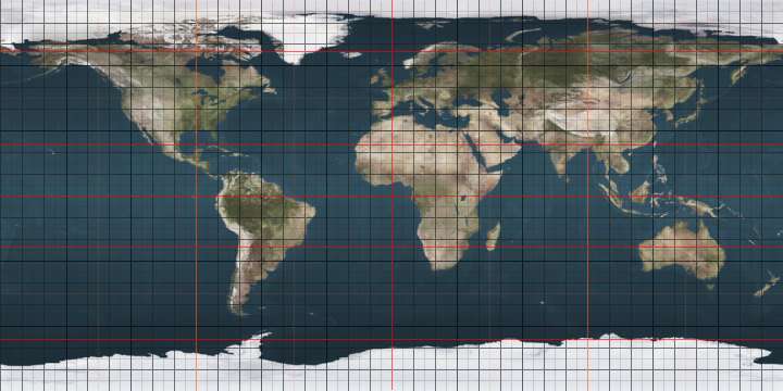
| Lines of latitude appear horizontal with varying curvature in this projection; but are actually circular with different radii. All locations with a given latitude are collectively referred to as a circle of latitude. |
|
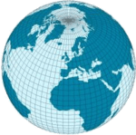
The equator divides the planet into a Northern Hemisphere and a Southern Hemisphere, and has a latitude of 0°. |
| Geodesy | ||||||||||||||||
|---|---|---|---|---|---|---|---|---|---|---|---|---|---|---|---|---|
 | ||||||||||||||||
| Fundamentals | ||||||||||||||||
| Concepts | ||||||||||||||||
| Technologies | ||||||||||||||||
| Standards | ||||||||||||||||
|
||||||||||||||||
| History | ||||||||||||||||

A circle of latitude on the Earth is an imaginary east–west circle connecting all locations (ignoring elevation) with a given latitude. A location's position along a circle of latitude is given by its longitude. Circles of latitude are often called parallels because they are parallel to each other – that is, any two circles are always the same distance apart. Unlike circles of longitude, which all are great circles with the centre of Earth in the middle, the circles of latitude get smaller as the distance from the Equator increases. Their length can be calculated by a common sine or cosine function. The 60th circle of latitude is half as long as the equator (disregarding Earth's minor flattening, which is less than 0.3%). A circle of latitude is perpendicular to all meridians.
The latitude of the circle is approximately the angle between the equator and the circle, with the angle's vertex at the Earth's centre. The equator is at 0°, and the North and South poles are at 90° north and 90° south respectively. The Equator is the longest circle of latitude and is the only circle of latitude which also is a great circle.
There are 89 integral (whole degree) circles of latitude between the equator and the Poles in each hemisphere, but these can be divided into more precise measurements of latitude, and are often represented as a decimal degree (e.g. 34.637°N) or with minutes and seconds (e.g. 22°14'26"S). There is no limit to how precisely latitude can be measured, and so there are an infinite number of circles of latitude on Earth.
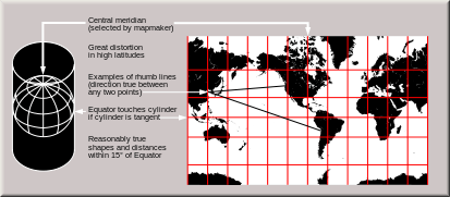
On a map, the circles of latitude may or may not be parallel, and their spacing may vary, depending on which projection is used to map the surface of the Earth onto a plane. On an equirectangular projection, centered on the equator, the circles of latitude are horizontal, parallel, and equally spaced. On other cylindrical and pseudocylindrical projections, the circles of latitude are horizontal and parallel, but may be spaced unevenly to give the map useful characteristics. For instance, on a Mercator projection the circles of latitude are more widely spaced near the poles to preserve local scales and shapes, while on a Gall–Peters projection the circles of latitude are spaced more closely near the poles so that comparisons of area will be accurate. On most non-cylindrical and non-pseudocylindrical projections, the circles of latitude are neither straight nor parallel.
Arcs of circles of latitude are sometimes used as boundaries between countries or regions where distinctive natural borders are lacking (such as in deserts), or when an artificial border is drawn as a "line on a map", which was made in massive scale during the 1884 Berlin Conference, regarding huge parts of the African continent. North American nations and states have also mostly been created by straight lines, which are often parts of circles of latitudes. For instance, the northern border of Colorado is at 41°N while the southern border is at 37°N. Roughly half the length of border between the United States and Canada follows 49°N.
Major circles of latitude

There are five major circles of latitude, listed below from north to south. The position of the Equator is fixed (90 degrees from the Earth's axis of rotation) but the latitudes of the other circles depend on the tilt of this axis relative to the plane of the Earth's orbit, and so are not perfectly fixed. The values below are for 8 December 2016:[1]
- Arctic Circle (66°33′46.5″ N)
- Tropic of Cancer (23°26′13.5″ N)
- Equator (0° latitude)
- Tropic of Capricorn (23°26′13.5″ S)
- Antarctic Circle (66°33′46.5″ S)
These circles of latitude, excluding the Equator, mark the divisions between the five principal geographical zones.
Equator
The equator is the circle that is equidistant from the North Pole and South Pole. It divides the Earth into the Northern Hemisphere and the Southern Hemisphere. Of the parallels or circles of latitude, it is the longest, and the only 'great circle' (a circle on the surface of the earth, centered on the center of the earth). All the other parallels are smaller and centered only on the earth's axis.
 |
| Equator |
Polar Circles
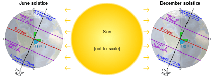
The Arctic Circle is the southernmost latitude in the Northern Hemisphere at which the sun can remain continuously above or below the horizon for 24 hours (at the June and December solstices respectively). Similarly, the Antarctic Circle marks the northernmost latitude in the Southern Hemisphere at which the sun can remain continuously above or below the horizon for 24 hours (at the December and June Solstices respectively).
|
|


Tropical Circles
The Tropic of Cancer and Tropic of Capricorn mark the northernmost and southernmost latitudes at which the sun may be seen directly overhead (at the June solstice and December solstice respectively).
The latitude of the tropical circles is equal to the Earth's axial tilt, about 23°.
|
|


Movement of the Tropical and Polar circles
By definition, the positions of the Tropic of Cancer, Tropic of Capricorn, Arctic Circle and Antarctic Circle all depend on the tilt of the Earth's axis relative to the plane of its orbit around the sun (the "obliquity of the ecliptic"). If the Earth were "upright" (its axis at right angles to the orbital plane) there would be no Arctic, Antarctic, or Tropical circles: at the poles the sun would always circle along the horizon, and at the equator the sun would always rise due east, pass directly overhead, and set due west.
The positions of the Tropical and Polar circles are not fixed because the axial tilt changes slowly – a complex motion determined by the superimposition of many different cycles (some of which are described below) with short to very long periods. In 2000 the mean value of the tilt was about 23° 26′ 21″.
The main long-term cycle causes the axial tilt to fluctuate between about 22.1° and 24.5° with a period of 41,000 years. Currently, the average value of the tilt is decreasing by about 0.47″ per year. As a result, (approximately, and on average) the Tropical Circles are drifting towards the equator (and the Polar Circles towards the poles) by 15 metres per year, and the area of the Tropics is decreasing by 1,100 square kilometres (420 sq mi) per year.
The Earth's axial tilt has additional shorter-term variations due to nutation, of which the main term, with a period of 18.6 years, has an amplitude of 9.2" (corresponding to almost 300 metres north and south).[2] There are many smaller terms, resulting in varying daily shifts of some metres in any direction.
Finally, the Earth's rotational axis is not exactly fixed in the Earth, but undergoes small fluctuations (on the order of 15 meters) called polar motion, which have a small effect on the Tropics and Polar circles and also on the Equator.
Short-term fluctuations over a matter of days do not directly affect the location of the extreme latitudes at which the sun may appear directly overhead, or at which 24-hour day or night is possible, except when they actually occur at the time of the solstices. Rather, they cause a theoretical shifting of the parallels, that would occur if the given axis tilt were maintained throughout the year.
Other notable parallels
A number of sub-national and international borders were intended to be defined by, or are approximated by, parallels. Parallels make convenient borders in the northern hemisphere because astronomic latitude can be roughly measured (to within a few tens of meters) by sighting the North Star.
| Parallel | Description |
|---|---|
| 70°N | On Victoria Island, Canada, two sections of the border between Northwest Territories and Nunavut. |
| 60°N | In Canada, the southern border of Yukon with the northern border of British Columbia; the southern border of Northwest Territories with the northern borders of British Columbia, Alberta and Saskatchewan; and the southern border of mainland Nunavut with the northern border of Manitoba, leading to the expression "north of sixty" for the territories. |
| 54°40'N | The border between 19th century Russian territories to the north and conflicting American and British land claims in western North America. The conflicting claims led to the Oregon boundary dispute between Britain and the United States, giving rise to the slogan "Fifty-four forty or fight." |
| 52°N | In Canada, part of the border between Newfoundland and Labrador and Quebec. |
| 51°N | The southern limit of Russian America from 1799 to 1821. |
| 49°N | Much of the border between Canada and the United States, from British Columbia to Manitoba; "49th parallel" is a common expression for the border, though the majority of Canada's population actually lives south of the parallel. |
| 48°N | In Canada, part of the border between Quebec and New Brunswick. |
| 46°N | In the United States, part of the border between Washington and Oregon. |
| 45°N | Part of the border between Canada (Quebec) and the USA (New York and Vermont) is approximated by the parallel. Also, in the USA, it approximates most of the border between Montana and Wyoming. |
| 43°30'N | In the USA, the border between Minnesota and Iowa. |
| 43°N | In the USA, much of the border between South Dakota and Nebraska. |
| 42°30'N | In the USA, the border between Wisconsin and Illinois. |
| 42°N | Originally the northward limit of New Spain. In the USA, the southern borders of Oregon and Idaho where they meet the northern borders of California, Nevada and Utah. The parallel also defines much of the border between Pennsylvania and New York. |
| 41°N | In the USA, part of the border between Wyoming and Utah, the border between Wyoming and Colorado, and part of the border between Nebraska and Colorado. |
| 40°N | In the USA, the border between Nebraska and Kansas. The parallel was originally chosen for the Mason–Dixon line, but the line was moved several miles south to avoid bisecting the city of Philadelphia. |
| 38°N | The boundary between the Soviet and American occupation zones in Korea, and later between North Korea and South Korea, from 1945 until the Korean War (1950–1953). |
| 37°N | In the USA, the southern border of Utah with the northern border of Arizona. The southern border of Colorado with the northern borders of New Mexico and Oklahoma. The southern border of Kansas with the northern border of Oklahoma. |
| 36°30'N | 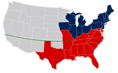 |
| 36°N | In the USA, a short section of the border between the Missouri Bootheel and Arkansas. |
| 35°N | In the USA, the southern border of Tennessee, which meets Mississippi, Alabama and Georgia. Also, part of the border between North Carolina and Georgia. |
| 33°N | In the USA, the southern border of Arkansas, which meets the northern border of Louisiana, is approximated by the parallel. Historically, it defined the southern border of the Louisiana Territory. |
| 32°N | In the USA, part of the border between New Mexico and Texas. |
| 31°20'N | Part of the border between the USA and Mexico (Sonora and Chihuahua); the southern border of Arizona and the New Mexico Bootheel. |
| 31°N | Part of the border between Iran and Iraq. In the USA, part of the border between Mississippi and Louisiana, and part of the border between Alabama and Florida. |
| 28°N | In Mexico, the border between Baja California and Baja California Sur. |
| 26°N | Part of the border between Western Sahara (claimed by Morocco) and Mauritania. |
| 25°N | Part of the border between Mauritania and Mali. |
| 22°N | Much of the border between Egypt and Sudan, partly disputed (see also Hala'ib Triangle). |
| 20°N | A short section of the border between Libya and Sudan, and within Sudan, the northern border of the Darfur region. |
| 17°N | The division between Republic of Vietnam (South Vietnam) and Democratic Republic of Vietnam (North Vietnam) during the Vietnam War. |
| 15°N | de facto maritime border between Honduras and Nicaragua.[3] |
| 13°05'N | Part of the border between Chad and Cameroon, over a stretch of 41.6 km, partly in Lake Chad |
| 10°N | Part of the border between Guinea and Sierra Leone. |
| 8°N | Part of the border between Somalia and Ethiopia. |
| 1°N | Part of the border between Equatorial Guinea and Gabon. |
| 1°S | Most of the border between Uganda and Tanzania, and a very short section of the border between Kenya and Tanzania in Lake Victoria. |
| 7°S | A short section of the border between Democratic Republic of the Congo and Angola. |
| 8°S | Two short sections of the border between Democratic Republic of the Congo and Angola. |
| 10°S | A short section of the border between Brazil and Peru. |
| 13°S | Part of the border between Angola and Zambia. |
| 16°S | Part of the border between Mozambique and Zimbabwe. |
| 22°S | A short section of the border between Namibia and Botswana, and parts of the border between Bolivia and Argentina. |
| 26°S | In Australia, the border between South Australia and the Northern Territory, and part of the border between South Australia and Queensland. |
| 28°S | In Argentina, the border between Chaco Province and Santa Fe Province. |
| 29°S | In Australia, much of the border between Queensland and New South Wales. |
| 35°S | In Argentina, part of the border between Córdoba Province and La Pampa Province. |
| 36°S | In Argentina, part of the border between Mendoza Province and La Pampa Province, and part of the border between San Luis Province and La Pampa Province. |
| 42°S | In Argentina, the border between Río Negro Province and Chubut Province. |
| 46°S | In Argentina, the border between Chubut Province and Santa Cruz Province. |
| 52°S | Part of the border between Argentina and Chile. |
| 60°S | The northern boundary of Antarctica for the purposes of the Antarctic Treaty System (see map). The northern boundary of the Southern Ocean. |
Altitude

Altitude has an effect on a location's position relative to the plane formed by a circle of latitude. Since altitude is determined by the normal to the Earth's surface, locations sharing the same latitude—but having different elevations (e.g., lying along this normal)—no longer lie within this plane. Rather, all points sharing the same latitude and of varying elevation occupy a cone formed by the rotation of this normal around the Earth's axis.
References
- ↑ "''Trópico en movimiento'' (in Spanish)". Groups.google.com. Retrieved 2014-05-13.
- ↑ "Basics of Space Flight, Chapter 2". Jet Propulsion Laboratory. Jet Propulsion Laboratory/NASA. 2013-10-29. Retrieved 2015-03-26.
- ↑ "Maritime Delimitation between Nicaragua and Honduras in the Caribbean Sea (Nicaragua v. Honduras)" (PDF). Retrieved 2014-05-13.
External links
| Wikimedia Commons has media related to Latitudes. |
|