Paradise, Missouri
| Paradise, Missouri | |
|---|---|
| unincorporated community | |
 Paradise  Paradise | |
| Coordinates: 39°25′39″N 94°30′57″W / 39.42750°N 94.51583°WCoordinates: 39°25′39″N 94°30′57″W / 39.42750°N 94.51583°W | |
| Country | United States |
| State | Missouri |
| Clay | Clay |
| Elevation | 925 ft (282 m) |
| Time zone | Central (CST) (UTC-6) |
| • Summer (DST) | CST (UTC-5) |
| GNIS feature ID | 730173[1] |
Paradise is an unincorporated community in Clay County, in the U.S. state of Missouri.[1]
History
In 1832, the US Government deeded 40 acres (16 ha) of land at this location to Mr. Pleasant Gentry. The land was sold in 1850 to John Gosney, who surveyed the land. The developing town was named "Gosneyville". Gosneyville was renamed "Paradise" around 1884.[1]
A post office called Paradise was established in 1858, and remained in operation until 1907.[2] The community was so named for the many churches in town relative to its small size.[3]
References
- 1 2 3 U.S. Geological Survey Geographic Names Information System: Paradise
- ↑ "Post Offices". Jim Forte Postal History. Retrieved 21 September 2016.
- ↑ "Clay County Place Names, 1928–1945 (archived)". The State Historical Society of Missouri. Retrieved 21 September 2016.
Municipalities and communities of Clay County, Missouri, United States | ||
|---|---|---|
| Cities | 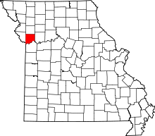 | |
| Villages | ||
| Townships |
| |
| Unincorporated communities | ||
| Footnotes | ‡This populated place also has portions in an adjacent county or counties | |
This article is issued from Wikipedia - version of the 10/2/2016. The text is available under the Creative Commons Attribution/Share Alike but additional terms may apply for the media files.