Parachinar
| Parachinar Parachiner, Pārachinār | |
|---|---|
| City | |
 | |
 Parachinar | |
| Coordinates: 33°53′57″N 70°6′3″E / 33.89917°N 70.10083°ECoordinates: 33°53′57″N 70°6′3″E / 33.89917°N 70.10083°E | |
| Country |
|
| Extra Provincial Subdivision | FATA |
| Tribal Agency | Kurram Valley |
| Elevation | 1,705 m (5,597 ft) |
| Time zone | PST (UTC+5) |
| Website |
www |
| [1] | |
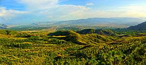
Parachinar (Urdu: پاڑاچنار, Pashto: پاړا چنار) is the capital of Kurram Agency, and the largest city of the Federally Administered Tribal Areas of Pakistan. Parachinar is situated on a neck of Pakistani territory south of Peshawar, that juts into Paktia Province of Afghanistan. It is the closest point in Pakistan to Kabul and borders on the Tora Bora region of Afghanistan. Turi, Bangash, Orakzai, Zazai, Mangal and Para Tsamkani are the major tribes and Christian, Hindus and Sikhs are the Minorities of Parachinar. Parachinar has four seasons. Parachinar is very famous for its fresh fruits and fresh vegetables.
History
The name Parachinar may derive from a large Chinar tree at a place now encompassed by the headquarters of Kurram Agency. Alternatively, there is in the Kurram Agency a tribe known as the Para-chamkani (Lisyani), which is remembered to have convened meetings under a Chinar tree to resolve their social matters.[2] The previous name, used for Kurram was Tutki, which is still used by some Afghan people. The inhabitants of Tutki were called Tutkiwal.
~The Kurram Valley.~--The Kurram Valley, which is drained by the Kurram river and its affluents, lies to the south of the lofty Safed Koh range, and reaches from Thal in Kohát to the Peiwar Kotal on the borders of Afghán Khost. It has an area of nearly 1300 square miles and in 1911 the population was estimated at 60,941 people. Though under British administration, it does not form a part of any British district. The people are Pathans of various clans, the predominant element being the Turis, who are Shias by religion and probably of Turkish origin. It was at their request that the valley was annexed in 1892. The political agent has his headquarters at Parachinar in Upper Kurram, which is divided from Lower Kurram by a spur of the Khost hills, through which the river has cut a passage. Such part of the Indian penal law as is suitable has been introduced, and civil rights are governed by the customary law of the Turís. A complete record of rights in land and water has been framed, and the land revenue demand is 88,000 rupees (£5889). Upper Kurram is a wide and fertile valley set in a frame of pine-clad hills. It is not fully cultivated, but has great possibilities, especially in the matter of fruit growing. The snowfall is heavy in winter, but the summer climate is excellent. Lower Kurram is a poor and narrow glen unpleasantly hot and cold according to the season of the year. Parachinár is connected with the railhead at Thal by a good _tonga_ road. reference
Parachinar originated as a summer residence for nomadic tribes who wintered their livestock at lower altitudes, and the district had originally been a summer residence for Moghul emperors from Delhi. The Parachinar region was part of Durrani empire before the Second Afghan War of 1878-79, but was not firmly annexed by the British until 1892. During the colonial era and 1947, Parachinar became a hill station for people from Peshawar; as it is relatively cool in the summer and very easy to reach from the plains despite its high altitude since there are no steep ascents on the route from Peshawar.
Because of its proximity to the border of Afghanistan, in recent years, the economy of Parachinar has been adversely affected, with tourism in steep decline. The region is known for sectarian clashes between Taliban and Shiites since 2004 when the US-led invasion of Afghanistan forced Taliban and Al-Qaeda militants to flee across the border.
Climate
Parachinar has a moderate humid subtropical climate (Köppen climate classification Cfa) with much higher rainfall than most areas of Pakistan. Although the city’s southeasterly aspect relative to the valley in which it is situated allows it to receive on occasions significant monsoonal rainfall, the most frequent source of rain is western depressions and related thunderstorms. During the winter, snowfall is common, and frosts occur on most mornings. Snow closes the Peiwar Pass, located on the Paktia border just over 20 km west of Parachinar, for up to five months per year.
| Climate data for Parachinar | |||||||||||||
|---|---|---|---|---|---|---|---|---|---|---|---|---|---|
| Month | Jan | Feb | Mar | Apr | May | Jun | Jul | Aug | Sep | Oct | Nov | Dec | Year |
| Record high °C (°F) | 20.6 (69.1) |
20.2 (68.4) |
29.0 (84.2) |
31.7 (89.1) |
37.4 (99.3) |
38.6 (101.5) |
36.4 (97.5) |
34.6 (94.3) |
36.2 (97.2) |
32.2 (90) |
26.3 (79.3) |
23.0 (73.4) |
38.6 (101.5) |
| Average high °C (°F) | 9.9 (49.8) |
10.4 (50.7) |
14.9 (58.8) |
21.3 (70.3) |
26.6 (79.9) |
30.7 (87.3) |
29.6 (85.3) |
28.4 (83.1) |
27.1 (80.8) |
23.2 (73.8) |
18.2 (64.8) |
12.7 (54.9) |
21.08 (69.96) |
| Daily mean °C (°F) | 4.2 (39.6) |
4.8 (40.6) |
9.6 (49.3) |
15.6 (60.1) |
20.3 (68.5) |
24.5 (76.1) |
24.5 (76.1) |
23.5 (74.3) |
21.3 (70.3) |
16.7 (62.1) |
11.5 (52.7) |
6.7 (44.1) |
15.27 (59.48) |
| Average low °C (°F) | −1.6 (29.1) |
−0.8 (30.6) |
4.2 (39.6) |
9.9 (49.8) |
14.1 (57.4) |
18.3 (64.9) |
19.5 (67.1) |
18.5 (65.3) |
15.6 (60.1) |
10.2 (50.4) |
5.0 (41) |
0.7 (33.3) |
9.47 (49.05) |
| Record low °C (°F) | −15 (5) |
−11.2 (11.8) |
−6.6 (20.1) |
1.7 (35.1) |
5.2 (41.4) |
8.0 (46.4) |
13.3 (55.9) |
12.8 (55) |
6.1 (43) |
3.4 (38.1) |
−2.0 (28.4) |
−7.2 (19) |
−15 (5) |
| Average precipitation mm (inches) | 44.9 (1.768) |
73.3 (2.886) |
127.3 (5.012) |
87.6 (3.449) |
65.8 (2.591) |
44.8 (1.764) |
107.1 (4.217) |
102.2 (4.024) |
55.1 (2.169) |
22.4 (0.882) |
17.4 (0.685) |
33.8 (1.331) |
781.7 (30.778) |
| Mean monthly sunshine hours | 214.5 | 198.8 | 209.4 | 233.5 | 292.1 | 297.3 | 285.7 | 280.6 | 270.2 | 284.3 | 260.1 | 199.2 | 3,025.7 |
| Source: NOAA (1971-1990) [3] | |||||||||||||
Durand Line Agreement at Parachinar
In 1893, during the rule of AMIR Asif Rahman Khan BANGASH of Afghanistan, a Royal Commission for demarcating a Boundary between Afghanistan and the territory of British governed India negotiated terms, agreeing to the Durand line. Two parties camped at Parachinar, now part of FATA Pakistan, which is near Khost Afghanistan.
From the British side the camp was attended by Sir Mortimer Durand and Sahibzada Abdul Qayyum, Political Agent Kurram. The Afghanistan interest was represented by Sahibzada Abdul Latif and the Governor Khost Sardar Shireendil Khan, representing King Amir Abdur Rahman Khan.[4]
Demography
The population consists of largely Pashto-speaking Sayed, Turi, Bangash, Orakzai, Mangal, Para Tsamkani, Zazai, Malekhel, Ghilzai, Muqbil, Hazara, Khoshi Christian and as well as a Sikh community.
Health Department
Agency surgeon is the head of local health department, which is also an 18 grade officer. Medical superintendent is the head of Agency headquarters hospital, who is a 19 grade officer.
Education
Parachinar is considered as having highest literacy rate among all tribal areas of Pakistan. Education for female is emphasized as a matter of importance of education equally for all Muslims. Parachinar city is the hub of educational institutions for the whole population of Kurram Agency. Beside governmental network of F.G schools,primary, middle and secondary schools, a reasonable number of private schools also exist. Notable private schools in Parachinar are The Smart School Parachinar (A project of The City School Pakistan..Internationally in six countries), Governor Model School, Paragons Innovative Public School (PIPS), International Public School Tari Mangal, Chinar Public High school, pilot model high school, Kurram public high school, Oxford public school,al qasim public school, Islamia public school, Kohsar Public High School, Allama Iqbal Public High School,a Uswa Public High School, Alamdar Public School and dozens of government high schools, Government High School No. 1 and Government High School No 2. As for as the Kurram Agency overall literacy rate is concerned, it is 6.25% whereas 11.04% for men and 0.85% for females. The upper Kurram is leading with the highest literacy rate 10.1% Overall and 18% for males. It is followed by the lower Kurram with a literacy rate of 8.23% whereas 15% for males. The overall literacy rate of FR Kurram is 1.66%, with a rate of 2.5% for males and 0.71% for females. As education rate is higher in upper Kurram with 2.5% as compared to lower Kurram 2.2% and also the primary education too. The only 0.3% F.R Kurram population had completed the primary level in 1980. There are three government colleges: Government Post Graduate College Parachinar, Government College of Management Sciences Parachinar, and Benazir College for Girls Parachinar.
Rest houses in Parachinar
- Circuit House
- Chapri Rest House (Approximately 9,941 feet or 3,030 metres altitude)
- Malana dam rest house
- Parachinar rest house, in the main city of Parachinar
See also
References
- ↑ Parachinar, Pakistan Page. Falling Rain Genomics, Inc. 1996-2004
- ↑ Khyber
- ↑ "Parachinar Climate Normals 1971-1990". National Oceanic and Atmospheric Administration. Retrieved January 16, 2012.
- ↑ http://www.aaiil.org/aaiil/ra/jalsa/2003/sahibzadaabdullatifshaheed100anniversary/08sahibzadazahoorahmad_sahibzadaabdullatifshaheed. mp3