Papegem
| Papegem | |
|---|---|
| Hamlet | |
|
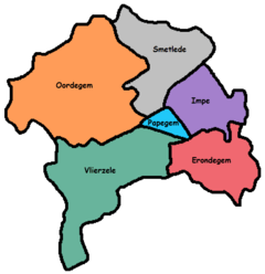
Localisation of Papegem, the community of Lede and the arrondissement of Aalst in the province of East-Flanders. | |
 Papegem | |
| Coordinates: 50°57′14″N 3°55′52″E / 50.95389°N 3.93111°E | |
| Country | Belgium |
| Region |
|
| Province |
|
| Arrondissement | Aalst |
| Municipality |
|
| Area | |
| • Total | 0.58 km2 (0.22 sq mi) |
| Population | |
| • Total | 449 |
| • Density | 774/km2 (2,000/sq mi) |
| Postal code | 9340 |
| Area code | 053 |

Papegem is a hamlet in the municipality of Lede located in the Belgian province of East Flanders in the Denderstreek. It has an area of 0.58 km². The Wellebeek (a brook) which flows there belongs to the basin of the Molenbeek which originates from the Upper Scheldt, and flows through Erpe-Mere. In the past the Wellebeek was called the Papegemsche beek. It is bordered by the sub-municipalities of Oordegem, Smetlede and Impe, as well as the municipalities of Sint-Lievens-Houtem (sub-municipality Vlierzele) and Erpe-Mere (sub-municipality Erondegem, despite the small size of Papegem. In Papegem the Sint-Macharius Chapel can be found. Papegem belongs to the deanery of Herzele-Houtem.
History
The Sint-Macharius Chapel was founded in 1890 on account of a typhus epidemic. It was inaugurated on 10 May 1891. In 1958/1959 there was a temporary church built which was received by the inauguration of Macharius as a patron saint. Before the merger of the municipalities in 1977, Papegem was a residential area of Vlierzele and had no street names. However, Papegem is now a hamlet with about 400 inhabitants. Every year on the first weekend after the 8 May, there is a 9 day procession in honor of the Holy Macharius with a fair.
Location
 |
 |
| Papegem and his neighbouring sub-municipalities | Localisation of Papegem in Lede |
Landmarks
- Sint-Machariuschurch
- Sint-Machariuschappel at Papegemstraat
- Onze Lieve Vrouwchappel at Putbosstraat
- Hof te Papegem, abbeyfarm, Papegemstraat 95
- View on Papegem at Papegemstraat, which has border signs of a sub-municipality
 The church of Papegem
 The little chapel at Papegemstraat
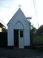 The little chapel at Putbosstraat
 A farm at Papegemstraat
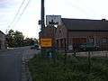 View on Papegem at Papegemstraat