Panjakent
| Panjakent | |
|---|---|
|
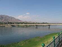
Panjakent Bazaar | |
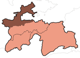
 Panjakent Location of Panjakent District in Tajikistan.png | |
| Coordinates: 39°30′N 67°37′E / 39.500°N 67.617°E | |
| Country |
|
| Province | Sughd |
| Elevation[1] | 996 m (3,268 ft) |
| Population (2000) | |
| • Total | 33,000 |
| Time zone | UTC+5 |

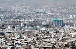
Panjakent (Tajik: Панҷакент; Persian: پنجکنت; Russian: Пенджикент), also spelled Panjikent, Panjekent, Panjikant or Penjikent, is a city in the Sughd province of Tajikistan on the Zeravshan River, with a population of 33,000 (2000 census). It was once an ancient town in Sogdiana. The ruins of the old town are on the outskirts of the modern city. The Sarazm Important Bird Area lies downstream of the city on the tugay-vegetated floodplain of the river.
History
Ancient Panjekent was a small but flourishing town of the Soghdians in pre-Islamic Central Asia. It was known as Panchekanth.[2] It means five towns (villages). The ethnic and territorial name "Soghd/Soghdian" or Sughd/Sughdian was mentioned in history as early as the Iranian Achaemenid Dynasty (6th century BC). The Achaemenids founded several city-states, as well as cities along the ancient Silk road and in the Zarafshan valley.
.jpg)
The town grew in the 5th century AD and many professionals such as established businessmen and landowners made their livelihoods in Panjakent. In AD 722, Arabian forces besieged and took the town. The last ruler of the town Divashtich fled into upper Zarafshan but he was captured and sentenced to death. For around 50 years, ancient Panjakent was ruled by new administrators but towards the end of the 8th century the town on the upper terraces was depopulated and relocated. Many ancient ruins of the old city, particularly the city architecture and works of art remain today.

According to Arab geographers, Panjakent in the 10th century had a formal Friday mosque that distinguished the place as a town from a village. It was the easternmost city of Soghd, and became well known for its walnuts. [3]
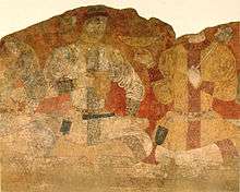
Russian archaeologist Boris Marshak spent more than fifty years excavating the ruins at Panjakent.[4] He remained there even after Tajik independence as director of the excavation of the Panjakent ruins, during the years of Civil War in Tajikistan from 1992 to 1997. Through close cooperation with the government of Tajikistan, Marshak ensured the protection and continued excavation of the Panjakent ruins. An important feature of the ruins is the frescoes which show details of dress and daily life.
Shaivism was popular in Sogdiana and Eastern Turkestan as found from the wall painting from Penjikent on the river Zervashan. In this depiction, Shiva is portrayed with a sacred halo and a sacred thread ("Yajnopavita"). He is clad in a tigerskin while his attendants are wearing Sodgian dress. In Eastern Turkestan in the Taklamakan Desert. There is a depiction of him four-legged seated cross-legged on a cushioned seat supported by two bulls.
Geography
Climate
The Köppen Climate Classification sub-type for Panjakent is "Cfb" or a Warm Summer Subtropical Climate. The average annual temperature is 10.7°C (51.3°F). The warmest month is July with an average temperature of 22.8°C (73°F) and the coolest month is January with an average temperature of -1.6°C (29.1°F). The average annual precipitation is 468.5mm (18.4") and has an average of 87.9 days with precipitation. The wettest month is April with an average of 94mm (3.7") of precipitation and the driest month is August with an average of 2.6mm (0.1") of precipitation.[1]
| Climate data for Panjakent (Pendzikent-38705) | |||||||||||||
|---|---|---|---|---|---|---|---|---|---|---|---|---|---|
| Month | Jan | Feb | Mar | Apr | May | Jun | Jul | Aug | Sep | Oct | Nov | Dec | Year |
| Daily mean °C (°F) | −1.6 (29.1) |
−0.4 (31.3) |
4.9 (40.8) |
11.2 (52.2) |
15.6 (60.1) |
20.5 (68.9) |
22.8 (73) |
21.1 (70) |
16.4 (61.5) |
10.4 (50.7) |
5.5 (41.9) |
1.4 (34.5) |
10.7 (51.3) |
| Average precipitation mm (inches) | 53.0 (2.087) |
53.2 (2.094) |
85.0 (3.346) |
94.0 (3.701) |
62.6 (2.465) |
11.1 (0.437) |
6.0 (0.236) |
2.6 (0.102) |
4.6 (0.181) |
31.8 (1.252) |
33.9 (1.335) |
48.7 (1.917) |
468.5 (18.445) |
| Average precipitation days (≥ 0.1 mm) | 10.7 | 11.3 | 13.5 | 12.1 | 9.3 | 3.1 | 2.3 | 1.2 | 1.7 | 5.6 | 7.5 | 9.6 | 87.9 |
| Average relative humidity (%) | 66.1 | 66.9 | 64.4 | 60.9 | 53.8 | 42.3 | 41.3 | 42.1 | 45.3 | 55.1 | 59.1 | 64.4 | 55.1 |
| Source: "The Climate of Panjakent". Weatherbase. Retrieved 7 August 2014. | |||||||||||||
References
- 1 2 "Climate of Panjakent". Weatherbase.com. Retrieved 7 August 2014.
- ↑ Gorgâni, Tirdâd. "Welcome to Penjakent". GEOCITIES. Archived from the original on 2009-07-28. Retrieved July 23, 2008.
- ↑ Marshak, B.I. "Panjikant". Encyclopædia Iranica.
- ↑ Shkoda, V. (October 2003). "Marshak's Bibliography and CV.". Transoxiana Webfestschrift Series I. Transoxiana: Journal Libre de Estudios Orientales. Retrieved 2006-10-14.
External links
| Wikimedia Commons has media related to Panjakent. |
-
 Panjakent travel guide from Wikivoyage
 - Panjakent
- Travel tips to visit Penjakent
- OpenStreetMap
Coordinates: 39°30′N 67°37′E / 39.500°N 67.617°E
| Rank | Name | Administrative division | Pop. | ||||||
|---|---|---|---|---|---|---|---|---|---|
 Dushanbe 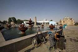 Khujand |
1 | Dushanbe | Dushanbe | 775,800 |  Qurghonteppa  Kulob | ||||
| 2 | Khujand | Sughd | 169,700 | ||||||
| 3 | Qurghonteppa | Khatlon | 101,600 | ||||||
| 4 | Kulob | Khatlon | 99,700 | ||||||
| 5 | Istaravshan | Sughd | 58,600 | ||||||
| 6 | Vahdat | Region of Republican Subordination | 52,900 | ||||||
| 7 | Tursunzoda | Region of Republican Subordination | 50,900 | ||||||
| 8 | Konibodom | Sughd | 48,900 | ||||||
| 9 | Isfara | Sughd | 45,900 | ||||||
| 10 | Panjakent | Sughd | 40,000 | ||||||