Pandacan
| Pandacan | |
|---|---|
 | |
| Country | Philippines |
| Region | National Capital Region |
| City | Manila |
| Congressional districts | Part of the 6th district of Manila |
| Barangays | 38 |
| Population (2007[1]) | |
| • Total | 76,134 |
Pandacan is a district in Manila, Philippines known for the Pandacan oil depot.
Profile

In 2000, Pandacan had a total population of close to 82,194. The original residents of the district are Tagalog migrants from the province of Bulacan. When the district grew and progressed as a manufacturing center for Manila, several ethnic groups from other parts of the country migrated into the district after the Second World War.
The district is bounded to the east by the Pasig River, the district of Santa Ana to the southwest Ermita to the east and the district of Paco to the northeast.
Socioeconomically, the majority of the residents of Pandacan range from lower- to upper-middle class. Original residents are gainfully employed as blue collar workers in the nearby factories and oil depots, while those in the service sector are generally employed in nearby Makati, the country's central business district.
Pandacan was originally established as the industrial center for the city of Manila during the turn of the 20th century. Oil depots which service more than half of the fuel requirement of the country were established along the banks of the Pasig River in the district.
Pandacan's western section, along Doctora Paz Mendoza-Guazon Street (formerly called Otis Street) was once a row for manufacturing such as coconut oil processing, rope making, and soda bottling and distribution for Coca-Cola. Pandacan hosts most of the country's auto dealerships and showrooms, such as Toyota, Honda, Nissan, Ford and Isuzu.
Landmarks
A portion of the Malacañan Palace, the official residence of the President of the Philippines is in Pandacan. A well-secured five-hectare property called Malacañang Park is at the foot of the Nagtahan Bridge, which serves as the barracks for the Presidential Security Guard.
The district is home to a few well-known historical figures, including Apolinario Mabini, one of the key figures in the Philippine fight for independence during the late 19th century against Spanish rule. The National Historical Commission of the Philippines has declared Mabini's former residence as a national historical shrine.
Former First Lady Imelda Romualdez Marcos claims Pandacan as her ancestral home in Manila. Since marrying former President Ferdinand Marcos in the 1960s, caretakers have been constantly maintaining her home. The house is Marcos' tie as a resident of Manila, despite her family's roots in Leyte province in the Visayas.
The head office and training center of the Roman Catholic Church's Catholic Charities under the Archdiocese of Manila is based in the district.
Schools
Public elementary schools serving the district includes Jacinto Zamora Elementary School, Bagong Diwa Elementary School, Beata Elementary School and Bagong Barangay Elementary School; the district has one public high school, the Carlos P. Garcia High School.
Private education is provided by a Catholic school called St. Joseph's School - Pandacan, located beside the Santo Niño Parish along Jesus Street.
In 1994, the ERDA Technical Vocational Secondary School was built by Fr. Pierre Tritz, a Jesuit from France for the disadvantaged Filipino youth.
In 2006, banker Alfonso Yuchengco opened the first modern privately run science high school called Malayan High School of Science (under the Mapua Institute of Technology system) on what was once the head office of the A. Soriano Corporation.
Churches
Four of the leading Christian religious dominations in the Philippines established their presence in the district. For Roman Catholics, there is the Santo Niño (Child Jesus) Parish along Jesus Street. The members of the Iglesia ni Cristo and the Pandacan United Methodist Church, both along President Quirino Avenue have a local, and the Aglipayan or members of the Iglesia Filipina Independiente (Parish of the Sto. Niño) have a church along Labores Street.
History
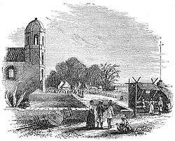
Officially, Pandacan was established as a community in 1574 when Franciscan priests of the Roman Catholic Church established the first mission in the district. Pandacan was originally part of the parish of Sampaloc; it was later established as a separate parish in 1712.
Pandacan was a farming community, producing small quantities of rice and sugar that were sold to the Spanish enclave in Intramuros. Aside from a few vegetable plots, the old Pandacan produced bricks and tiles, colored cotton laces but in limited quantities. The district also produced shoes and small boats.
In the 19th century, Pandacan was described as a "Little Venice" or "Little Italy" for its numerous canals or estuaries leading to the Pasig River. Many would leisurely row through the estuaries in the late afternoons as described by Francisco Balagtas in his early writings. Pandacan was home to balladeers and a source of musicians in the early times.
Late in the Spanish era and into the American regime, Pandacan was developed into becoming the first industrial estate in the Philippines. The first modern manufacturing company was built in Pandacan and was called the Compañia General de Tabacos de Filipinas in 1882, a modern cigar-making plant.
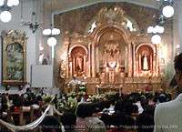
The first stone church in Pandacan was built in 1732 by Father Francisco del Rosario. The church would take 30 years to complete. The image of the Holy Child of Jesus or popularly known as Sto. Niño was enshrined at the church and its feast is traditionally celebrated on the third Sunday of January. According to legend, the image of the Santo Niño was recovered from a well near the church and some say the water from the well resulted in the miraculous healing of the infirm. The well has long been sealed due to pollutants but a shrine stands on what was once the well.
The original church, completed in 1760, was twice destroyed by earthquakes. A modern church now stands on the ruins including a parish school which stands on what was the Catholic cemetery of the district.
Pandacan was home to prominent Filipino artists of the 19th century, including Francisco Baltazar (also known as Balagtas) who authored Florante at Laura; musician Ladislao Bonus; Tagalog language theorist Lope K. Santos; and playwrights Miguel Masilungan and Pantaleon Lopez.
By the turn of the 19th century, the American colonial government decreed Pandacan as the center for industrial activity and had oil companies build their storage and distribution facilities in the district.
With the presence of several manufacturing facilities in the district, a modern housing facility was built to house the workers at the nearby oil depots. The housing project was called "Kapitan Tikong" (Captain Tikong) subdivision, named after a popular local leader. The housing facility was built on the southeastern banks of the Estero de Beata. In honor of Francisco Baltazar, the streets in the subdivision were named after the characters of Florante at Laura.
Modernization
From industrial to commercial
The manufacturing facilities in Pandacan have long transferred to other locations outside of Manila. Only the major "Big Three" oil companies operate oil distribution depots in Pandacan: Royal Dutch Shell, Chevron's Caltex and San Miguel Energy Corp. majority-owned Petron Philippines.
During the second term of Manila Mayor Joselito L. Atienza, Jr., he led an effort to convert Pandacan from an industrial classification into commercial, in an effort to have the oil depot removed from the district. Atienza and several city councilors were concerned that the oil depot served as a security, environment, and safety hazard to the densely populated Pandacan. Several fires have been attributed to the presence of the oil depot and terrorist attacks were a major concern.
Difficulty in finding a reasonable relocation site for the depots, without disturbing the national distribution process of fuel, resulted in a compromise in place of the eviction. However, a gradual phase out of large oil tanks that lined residential areas has been completed and a Pandacan Linear Park was built along the oil depot and residential units up to the banks of the Pasig River.
Beautification programs
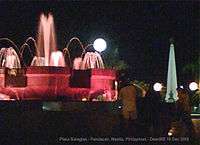
Atienza spearheaded a beautification program and spruced up parks and recreational facilities. This included the Plaza Balagtas that sits atop the Estero de Beata in 2003 and the Ladislao Bonus Park in 2006.
In September 2006, as part of Atienza's sidewalk redevelopment and street lighting program, the main highway from the corner of Jesus Street and Quirino Avenue at the foot of Nagtahan Bridge southwards into Palumpong Street and the whole of Laura Street up to the foot of the Padre Zamora Bridge was renovated, linking the walkways into the Pandacan Linear Park, a buffer zone made into a park separating the oil distribution facilities from the residential-commercial areas. The Pandacan Linear Park, developed under the support of the big three oil companies and the city government of Manila, allows for a leisure walk and recreational activities along the Pasig River.
Modern housing
Sections of the district are seeing improvements with a low-cost housing development in the site of the compound of the Manila City Engineer's Office beside the Nagtahan Bridge called "Residencias de Manila".
Tourism and Events
Manila boasts its rich cultural history every year in Pandacan with the traditional "Buling Buling" Dance Festival. Because many of the country's literary and musical geniuses of the 19th century came from Pandacan, an annual traditional dancing in the streets of Pandacan is featured every Saturday before the main celebrations for the feast of the Santo Niño every third week of January.
See also
- Culture of the Philippines
- Places of interest in Pandacan
- Demographic history of the Philippines
- ILOVEYOU virus
- Languages of the Philippines
- Timeline of Philippine history
References
- By Sword and Fire: The Destruction of Manila in World War II, 3 February-3 March 1945 by Alphonso J. Aluit (1994) Bookmark, Inc. © 1994 National Commission for Culture and the Arts ISBN 971-569-162-5
- Pandacan Oil Depot Relocation Plan Submitted, Business World, May 14, 2008.
- Torres, Tetch (May 7, 2009), Supreme Court to Oil firms: Move out of Pandacan depot, Philippine Daily Inquirer.
- Panaligan, Rey G. (April 4, 2011), Oil depot transfer pressed, Manila Bulletin.
External links
| Topics | 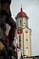 | |
|---|---|---|
| Government |
| |
| Districts | ||
| Legislative districts | ||
| ||
Cities and municipalities | |||||||||||||||||||
| |||||||||||||||||||
| |||||||||||||||||||
See also: Administrative divisions of Metro Manila | |||||||||||||||||||
Coordinates: 14°35′38″N 121°00′25″E / 14.594°N 121.007°E