Pampanga
| Pampanga | ||
|---|---|---|
| Province | ||
| Province of Pampanga | ||
|
Pampanga Provincial Capitol | ||
| ||
| Nickname(s): Culinary Capital of the Philippines, Tilapia Capital of the Philippines | ||
 Location in the Philippines | ||
| Coordinates: 15°04′N 120°40′E / 15.07°N 120.67°ECoordinates: 15°04′N 120°40′E / 15.07°N 120.67°E | ||
| Country | Philippines | |
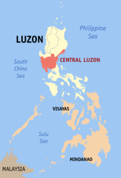
| Region | Central Luzon (Region III) | |
| Founded | December 11, 1571 | |
| Capital | San Fernando | |
| Government | ||
| • Type | Sangguniang Panlalawigan | |
| • Governor | Lilia G. Pineda (NUP/KAMBILAN) | |
| • Vice Governor | Dennis "Delta" G. Pineda (NPC/KAMBILAN) | |
| Area[1] | ||
| • Total | 2,002.2 km2 (773.1 sq mi) | |
| Area rank | 61st out of 81 | |
| (excluding Angeles City) | ||
| Population (2015 census)[2] | ||
| • Total | 2,198,110 | |
| • Rank | 9th out of 81 | |
| • Density | 1,100/km2 (2,800/sq mi) | |
| • Density rank | 5th out of 81 | |
| (excluding Angeles City) | ||
| Divisions | ||
| • Independent cities |
1
| |
| • Component cities | ||
| • Municipalities | ||
| • Barangays |
| |
| • Districts | 4 | |
| Demographics | ||
| • Ethnic groups |
| |
| • Languages | ||
| Time zone | PST (UTC+8) | |
| ZIP code | 2000–2024 | |
| IDD : area code | +63 (0)45 | |
| ISO 3166 code | PH-PAM | |
| Website |
www | |


Pampanga or Pampaŋga (Kapampangan: Lalawigan ning Pampanga; Filipino: Lalawigan ng Pampanga) is a province in the Central Luzon region of the Philippines. Lying on the northern shore of Manila Bay, Pampanga is bordered by Tarlac to the north, Nueva Ecija to the northeast, Bulacan to the east, the Manila Bay to the central-south, Bataan to the southwest and Zambales to the west. Its capital is the City of San Fernando. Angeles City, while geographically within Pampanga, is classified as a first-class, highly urbanized city and is governed independently of the province.
The name La Pampanga was given by the Spaniards, who encountered natives living along the banks (pampáng) of the Pampanga River. Its creation in 1571 makes it the first Spanish province on Luzon Island (Cebu in Visayas is older as it was founded by the Spaniards in 1565). The town of Villa de Bacolor in the province briefly served as the Spanish colonial capital when Great Britain invaded Manila as part of the Seven Years' War. At the eve of the Philippine Revolution of 1896, Pampanga was one of eight provinces placed under martial law for rebellion against the Spanish Empire; it is thus represented on the Philippine national flag as one of the eight rays of the sun.
Pampanga is served by Clark International Airport (formerly Diosdado Macapagal International Airport), which is in Clark Freeport Zone, some 16 kilometres (9.9 mi) north of the provincial capital. The province is home to two Philippine Air Force airbases: Basa Air Base in Floridablanca and the former United States Clark Air Base in Angeles City. By 2015, the province has 2,198,110 inhabitants,[2] while it has 1,079,532 registered voters.[3]
History
Ancient Pampanga's territorial area included portions of the modern provinces of Tarlac, Bataan, Zambales, Nueva Ecija and Bulacan. Pampanga was re-organized as a province by the Spaniards on December 11, 1571. For better administration and taxation purposes, the Spanish authorities subdivided Pampanga into pueblos, which were further subdivided into districts (barrios) and in some cases into royal and private estates (encomiendas).
Due to excessive abuses committed by some encomenderos, King Philip II of Spain in 1574 prohibited the further awarding of private estates, but this decree was not fully enforced until 1620. In a report of Philippine encomiendas on June 20, 1591, Governor-General Gómez Pérez Dasmariñas reported to the Crown that La Pampanga's encomiendas were Bataan, Betis y Lubao, Macabebe, Candaba, Apalit, Calumpit, Malolos, Binto, Guiguinto, Caluya, Bulacan and Mecabayan. The encomiendas of La Pampanga at that time had eighteen thousand six hundred and eighty whole tributes.
Pampanga, which is about 850 square miles (2,200 km2) in area and inhabited by more than 1.5 million people, had its present borders drawn in 1873. During the Spanish regime it was one of the richest Philippine provinces. Manila and its surrounding region were then primarily dependent on Kapampangan agricultural, fishery and forestry products as well as on the supply of skilled workers. As other Luzon provinces were created due to increases in population, some well-established Pampanga towns were lost to new emerging provinces in Central Luzon.
During the 17th century, The Dutch recruited men from Pampanga as mercenaries who served the Royal Netherlands East Indies Army, known as Papangers[4] part of the larger Mardijkers community. Their legacy can be found in North Jakarta,[5] however, there are few traces of their descendants, except for a small community in Kampung Tugu.

The historic province of Bataan which was founded in 1754 under the administration of Spanish Governor-General Pedro Manuel Arandia, absorbed from the province of Pampanga the municipalities of Abucay, Balanga (now a city), Dinalupihan, Llana Hermosa, Orani, Orion, Pilar, and Samal.
The old Pampanga towns of Aliaga, Cabiao, Gapan, San Antonio and San Isidro were ceded to the province of Nueva Ecija in 1848 during the term of Spanish Governor-General Narciso Claveria y Zaldua. The municipality of San Miguel de Mayumo of Pampanga was yielded to the province of Bulacan in the same provincial boundary configuration in 1848.
In 1860, the northern towns of Bamban, Capas, Concepcion, Victoria, Tarlac, Mabalacat, Magalang, Porac and Floridablanca were separated from Pampanga and were placed under the jurisdiction of a military command called Comandancia Militar de Tarlac. However, in 1873, the four latter towns were returned to Pampanga and the other five became municipalities of the newly created Province of Tarlac.
On December 8, 1941, Japanese planes bombed Clark Air Base marking the beginning of the invasion of Pampanga. Between 1941 and 1942, occupying Japanese forces began entering Pampanga.
During the counter-insurgencies under the Japanese occupation from 1942 to 1944, Kapampangan guerrilla fighters and the Hukbalahap Communist guerrillas fought side by side in the province of Pampanga, attacking and retreating the Japanese Imperial forces for over three years of fighting and invasion.
The establishment of the military general headquarters and military camp bases of the Philippine Commonwealth Army was active from 1935 to 1946. The Philippine Constabulary was active from 1935 to 1942 and 1944 to 1946 in the province of Pampanga. During the military engagements of the anti-Japanese Imperial military operations in central Luzon from 1942 to 1945 in the province of Bataan, Bulacan, Northern Tayabas (now Aurora), Nueva Ecija, Pampanga, Tarlac, and Zambales, the local guerrilla resistance fighters and Hukbalahap Communist guerrillas, helped the U.S. military forces fight the Imperial Japanese armed forces.
In the 1945 liberation of Pampanga, Kapampangan guerrilla fighters and the Hukbalahap Communist guerrillas supported combat forces from Filipino and American ground troops in attacking Japanese Imperial forces during the Battle of Pampanga until the end of the Second World War. Local military operations soldiers and officers of the Philippine Commonwealth Army 2nd, 21st, 26th, 3rd, 31st, 32nd, 33rd, 35th, 36th and 37th Infantry Division and the Philippine Constabulary 3rd Infantry Regiment recaptured and liberated the province of Pampanga and fought against the Japanese Imperial forces during the Battle of Pampanga.
After the Second World War, operations in the main province of Pampanga was downfall insurgencies and conflicts between the Philippine Government forces and the Hukbalahap Communist rebels on 1946 to 1954 during the Hukbalahap Rebellion.
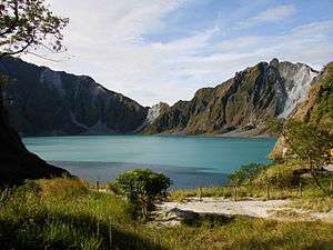
The June 1991 eruption of Mount Pinatubo displaced a large number of people with the submersion of whole towns and villages by massive lahar floods.
Geography
Pampanga covers a total area of 2,002.2 square kilometres (773.1 sq mi)[6] occupying the south-central section of the Central Luzon region. When Angeles City is included for geographical purposes, the province's area is 2,062.47 square kilometres (796.32 sq mi).[6] The province is bordered by Tarlac to the north, Nueva Ecija to the northeast, Bulacan to the east, the Manila Bay to the central-south, Bataan to the southwest, and Zambales to the northwest.
Its terrain is relatively flat with one distinct mountain, Mount Arayat and the notable Pampanga River. Among its municipalities, Porac has the largest land mass with 314 square kilometres (121 sq mi); Candaba comes in second with 176 square kilometres (68 sq mi); followed by Floridablanca with 175 square kilometres (68 sq mi). Santo Tomas, with an area of 21 square kilometres (8.1 sq mi), is the smallest.[6]
Climate
The province of Pampanga has two distinct climates, rainy and dry. The rainy or wet season normally begins in May and runs through October, while the rest of the year is the dry season. The warmest period of the year occurs between March and April, while the coolest period is from December through February.
|
 Political divisions | ||||||||||||||||||||||||||||||||||||||||||||||||||||||||||||||||||||||||||||||||||||
Administrative divisions
Pampanga comprises 19 municipalities and three cities (one highly urbanized and two component).
- † Provincial capital and component city
- ∗ Component city
- Municipality
- ‡ Highly urbanized city (geographically within but independent from the province)
| |||||||||||||||||||||||||||||||||||||||||||||||||||||||||||||||||||||||||||||||||||||||||||||||||||||||||||||||||||||||||||||||||||||||||||||||||||||||||||||||||||||||||||||||||||||||||||||||||||||||||||||||||||||||||||||||||||||||||||||||||||||||||||||||||||||||||||||||||||||||||||||||||||||||||||||||||||||||||||||||||||||||||||
Demographics
| Population census of Pampanga | ||
|---|---|---|
| Year | Pop. | ±% p.a. |
| 1990 | 1,295,929 | — |
| 1995 | 1,401,756 | +1.48% |
| 2000 | 1,614,942 | +3.08% |
| 2007 | 1,911,951 | +2.36% |
| 2010 | 2,014,019 | +1.91% |
| 2015 | 2,198,110 | +1.68% |
| (excluding Angeles City) Source: Philippine Statistics Authority[2][8][8] | ||
Population
The population of Pampanga in the 2015 census was 2,198,110 people,[2] with a density of 1,100 inhabitants per square kilometre or 2,800 inhabitants per square mile. If Angeles City is included for geographical purposes, the population is 2,609,744, with a density of 1,265/km2 (3,277/sq mi). The native inhabitants of Pampanga are generally referred to as Kapampangans (alternatively spelled Capampañgan), Pampangos or Pampangueños.
Languages
The whole population of Pampanga speak the language of Kapampangan, which is one of the Central Luzon languages along with the Sambalic languages. A few also speak Tagalog, especially in places close to the border of Bulacan. English is mainly spoken and used as a second language. There are also a few Sambal speakers in the province, especially near the border of Zambales.
Religion

The province of Pampanga is composed of many religious groups, but it is predominantly Roman Catholic, followed by the Members Church of God International, colloquially called Ang Dating Daan headed by Eliseo Soriano, with its headquarters in Apalit, Pampanga.
Other prominent Christian groups include the Aglipayan Church, Iglesia ni Cristo, United Methodist, Church of the Nazarene, The Church of Jesus Christ of Latter-day Saints, Jehovah's Witnesses, Pentecostal Missionary Church of Christ (4th Watch), Most Holy Church of God in Christ Jesus, Jesus is Lord Church, Seventh-day Adventist Church, Evangelicals, Aglipayan, Jesus Miracle Crusade and many others.
Islam is also present in the province, mainly due to migrants originating from the south, as well as Buddhism, which is practiced by a few Filipinos of Chinese descent.
Economy
Farming and fishing are the two main industries. Major products include rice, corn, sugarcane, and tilapia. Pampanga is the tilapia capital of the country because of its high production reaching 214,210.12 metric tons in 2015. In addition to farming and fishing, the province supports thriving cottage industries that specialize in wood carving, furniture making, guitars and handicrafts. Every Christmas season, the province of Pampanga, especially in the capital city of San Fernando becomes the center of a thriving industry centered on handcrafted lighted lanterns called parols that display a kaleidoscope of light and color. Other industries include its casket industry and the manufacturing of all-purpose vehicles in the municipality of Santo Tomas.
The province is famous for its sophisticated culinary work. Kapampangans are well known for their culinary creations. Famous food products range from the mundane to the exotic. Roel's Meat Products, Pampanga's Best and Mekeni Food are among the better known meat brands of the country producing Kapampangan favorites such as pork and chicken tocinos, beef tapa, hotdogs, and longganizas (Philippine-style sausages and cured meats).
Specialty foods such as the siopao, pandesal, tutong, lechon (roasted pig) and its sarsa (sauce) are popular specialty foods in the region. The more exotic betute tugak (stuffed frog), kamaru (mole crickets) cooked adobo, bulanglang (pork cooked in guava juice), lechon kawali and bringhe (a green sticky rice dish like paella) are a mainstay in Kapampangan feasts.
Native sweets and delicacies like pastillas, turonnes de casuy, buro, are the most sought after by Filipinos including a growing number of tourists who enjoy authentic Kapampangan cuisine. The famous cookie in Mexico, Pampanga, Panecillos de San Nicolas, which is known as the mother of all Philippine cookies, is made here, famously made by Lillian Borromeo.[10]
Tourism is a growing industry in the province of Pampanga. Clark Freeport is home to Clark International Airport, designated as the Philippines' future premier gateway. Other developing industries include semiconductor manufacturing for electronics and computers mostly located within the freeport.
Within the Clark Special Economic Zone are well-established hotels and resorts. Popular tourist destinations include St. Peter Shrine in Apalit, Mt. Arayat National Park in San Juan Bano, Arayat, the Paskuhan Village in the City of San Fernando, the Casino Filipino in Angeles City and, for nature and wildlife, "Paradise Ranch and Zoocobia Fun Zoo" in Clark. Well-known annual events include the Giant Lantern Festival in December, the hot air balloon festival in Clarkfield in February, the San Pedro Cutud Lenten Rites celebrated two days before Easter, and the Aguman Sanduk in Minalin celebrated on the afternoon of New Year's Day.
Infrastructure
Telecommunication
Telephone services are provided by the Philippine Long Distance Telephone Company (PLDT), Digitel, Datelcom, the Evangelista Telephone Company, and the Pampanga Telecom Company in the town of Macabebe. The province has 24 public telegraph offices distributed among its towns while the facilities of PT&T and RCPI were set up to serve the business centers in Angeles City, San Fernando City and Guagua.[11]
Several Internet service providers are available. These include the Angeles Computer Network Specialist, Information Resources Network System, Inc., Mosaic communications Inc., Net Asia Angeles City, Phil World On Line and Comclark Network and Technology Corp.
United Parcel Services (UPS) and Federal Express (FedEx) provide international courier services. Their hubs are in the Clark Freeport Zone. They are complemented by four local couriers operating as the communication and baggage of the province. There are three postal district offices and 35 post office stations distributed in the 20 municipalities and two cities of the province.[12]
Water and power
Potable water supply in the province reaches the populace through three levels namely: Level I (point source system), Level II (communal faucet system), and Level III (individual connections). A well or spring is the pinpointed water source in areas where houses are few as the system is only designed to serve 15 to 25 households. As of 1997, there were 128,571 Level I water system users in the province. The communal faucet system (Level II) serves the rural areas while the Level III system is managed by the Local Water Utilities Administration (LWUA). The system provides individual house connections to all second and first class private subdivisions.
Electric power is distributed to majority of the towns through the distribution centers of the Pampanga Electric Cooperative (PELCO) which include PELCO I, II, III. Small parts of Candaba and Macabebe are also supplied by Manila Electric Company (MERALCO). Angeles City and small parts of Mabalacat, Villa de Bacolor, and Porac are supplied by Angeles Electric Corporation (AEC). City of San Fernando is supplied by San Fernando Electric Company (SFELAPCO).[11]
Transportation
The province of Pampanga is strategically located at the crossroads of central Luzon and is highly accessible by air and land. The province is home to two airstrips: Basa Air Base in Floridablanca, which is used by the military, and Clark International Airport in Clark Freeport Zone. Pampanga has five municipal ports that function as fish landing centers. These are in the municipalities of Guagua, Macabebe, Masantol, Minalin, and Sasmuan.[11]
Land travel is made easy by buses that travel the routes of Manila-Pampanga-Bataan, Manila-Pampanga-Zambales, Manila-Pampanga-Tarlac, Manila-Pampanga-Nueva Ecija, Manila-Bulacan-Pampanga, and Manila-Pampanga-Dagupan.
The 84 kilometres (52 mi) North Luzon Expressway (NLEX) extends from Balintawak in Metro Manila to Sta. Ines in Pampanga. It passes through the large cities of San Fernando, Angeles and ends through Sta. Ines in Mabalacat, which is Clark Field, and municipalities of Minalin and San Simon
The 94 kilometres (58 mi) four-lane Subic-Clark-Tarlac Expressway (SCTEx) to date, is the longest toll expressway in the Philippines. Its southern terminus is in the Subic Bay Freeport Zone in Zambales and passes through the Clark Freeport Zone in two interchanges: Clark North and Clark South. The expressway is linked to the North Luzon Expressway through the Mabalacat Interchange. Its northern terminus is located at the Central Techno Park in Tarlac City, Tarlac.
Education
Colleges and universities
- AIE College (Angeles City)
- AMA Computer College (Angeles City and City of San Fernando)
- AMA Computer Learning Center (Angeles City and City of San Fernando)
- AMA Computer Learning Center (Apalit)
- Angeles University Foundation (Angeles City)
- Arayat Institute (Arayat)
- Arayat National High School (Arayat)
- Asian College of Science & Technology
- Asian Institute of Computer Studies (Mabalacat City and City of San Fernando)
- Central Luzon College of Science and Technology (CELTECH College),[13] (City of San Fernando)
- Church Education System Seminary & Institute of Religion, in every chapels of The Church of Jesus Christ of Latter-day Saints
- Colegio de Sebastian (City of San Fernando)
- Computer System Specialist, Inc. (Angeles City)
- Dau Academy-Saint Muchen (Mabalacat City)
- Dee Hwa Liong College Foundation (Mabalacat City)
- Development for Advanced Technology Achievement (DATA) College (City of San Fernando)
- Don Honorio Ventura Technological State University (Bacolor)
- Don Honorio Ventura Technological State University (Lubao)
- Don Honorio Ventura Technological State University (Mexico)
- Don Honorio Ventura Technological State University (Santo Tomas)
- East Central Colleges (City of San Fernando)
- Exact College of Asia (Arayat)
- Gateway Institute of Science and Technology (City of San Fernando)
- Guagua National Colleges (Guagua)
- Harvardian Colleges (City of San Fernando)
- Holy Angel University (Angeles City)
- Holy Cross College Pampanga (Santa Ana)
- Infant Jesus Academy (IJA)
- Information and Communication Technology High School (City of San Fernando)
- Integrated Computer School Foundation (Angeles City)
- Jocson College (Angeles City)
- Jose C. Feliciano College, Inc. (Mabalacat City)
- La Verdad Christian College (Apalit)
- Mabalacat College (Mabalacat City)
- Mary Help of Christians School Inc. (Mabalacat City)
- Mary the Queen College (Guagua)
- Mega Computer College (Angeles City)
- Megabyte College of Science and Technology (Floridablanca and Guagua)
- Mother of Good Counsel Major Seminary (City of San Fernando)
- Mother Of Good Counsel Minor Seminary (City of San Fernando)
- Mother of Perpetual Help Institute School of Midwifery and Nursing Aide (Angeles City)
- Mount Carmel Colleges (City of San Fernando)
- New Era University (City of San Fernando)
- NorthPoint Academy for Culinary Arts (City of San Fernando)
- Our Lady of Fatima University (City of San Fernando)
- Pampanga Colleges (Macabebe)
- Pampanga Institute (Masantol)
- Pampanga State Agricultural University (Magalang)
- Philippine State College of Aeronautics (Floridablanca)
- Proverbsville School (Angeles City/City of San Fernando)
- Republic Central Colleges (Angeles City)
- Saint Anthony College of Technology (Mabalacat City)
- Saint Mary's Angels College of Pampanga (Santa Ana)
- Saint Michael's College (Guagua)
- Saint Nicolas College of Business and Technology
- San Lorenzo Ruiz Center of Studies and Schools (City of San Fernando)
- Santa Rita College Integrated School (Santa Rita)
- Somascan Fathers Seminary (Lubao)
- Saint Augustine School of Nursing (Angeles City)
- STI Colleges (Angeles City and City of San Fernando)
- Systems Plus College Foundation, Inc. (Angeles City)
- TESDA Training Center (City of San Fernando)
- The Metropolitan Academy Of Arts & Beauty - Pampanga (City of San Fernando)
- University of the Assumption (City of San Fernando)
- University of the Philippines - Diliman Extension Program in Pampanga (Clark Freeport Zone)
Attractions
Festivals
- Every week of January "Sunday" — Ding labas larawan king Masantol (Masantol)
- April 10–13 — Lubao International Balloon Festival (Lubao)
- Every Last Saturday and Sunday of April — "PISTA ning INDU" - Festivity of Nuestra Señora dela Paz, REINA DE BATALYA / Apung Maria ning Macabebe - Ing Indung Lugud ning Balen (Macabebe)
- September 24 — feast day of Nuestra Señora De La Merced Mercedarian Festival Apung Dela Merced (Candaba)
- May 1 — Pinukpukan Festival (Floridablanca), Libad king San Pedro (San Simon, Pampanga)
- May 8 — Batalya ng San Miguel karing Morus Masantol "Batalla Festival" (Batalya) (Masantol)
- April every 3rd or 4th Sunday — Tabang Talangka Festival, San Roque de Montpelier (Masantol)
- August 15, 16, 17 — Batala Festival (Batalya) Batalya ng San Roque de Montpelier (Masantol)
- May 13 — Batalya ng San Nicolas (Masantol)
- December 13 Batalaya ng Apu Lucia (Masantol)
- January 1 — Aguman Sanduk (Minalin)
- January 6–10 — Kuraldal (Sasmuan)
- February — Philippine International Hot-Air Balloon Fiesta (Clark Field, Angeles City)
- February 28–29 — Caragan Festival (Mabalacat)
- March/April (Good Friday) — San Pedro Cutud Lenten Rites (Mal a Aldo) (City of San Fernando)
- May 5 — Sampaguita Festival of (Lubao)
- May — Sabat/Santacruzan
- May (first week) — El Circulo Fernandino
- June 15 — Mt. Pinatubo Day (Aldo ning Bunduc Pinatubo)
- June 28–30 — Apung Iru Fluvial Procession (Apalit)
- August 27 — Apung Monica Fluvial Procession (Minalin)
- September 10 — Sanikulas Festival (Mexico)
- September 28 — San Lorenzo Ruiz Feast (Mabalacat City)
- October — Pyestang Tugak (Frog Festival) (City of San Fernando)
- October — Fiestang Kuliat-Twin Fiesta (La Naval de Angeles and Apung Mamacalulu) (Angeles City)
- Last Friday and Saturday of October — Tigtigan Terakan Keng Dalan (Angeles City)
- November — Makatapak Festival (Bacolor)
- November (Last week of November) — Duman Festival (Santa Rita)
- December — Sisig Festival (Sadsaran Qng Angeles) (Angeles City)
- December 1–7 — Sinukwan Festival (City of San Fernando)
- December 11 — Aldo Ning Kapampangan (Pampanga Day)
- December — "Dukit Festival" (Betis)
- July and December — "Serenata" (Betis)
- December - La Purisima Concepcion Festival (Minalin)
- December (Saturday before Christmas Eve) — Ligligan Parul (Giant Lantern Festival) (City of San Fernando)
- December 16–24 — Lubenas (various towns in Northern Pampanga)
- El Circulos de Masantoleños
- Maharajah Macabebean
Throughout the year, various towns and cities within the Province of Pampanga celebrates feasts honoring their patron saint. These fiesta days are listed below:
- Angeles City — Second Sunday of October "Nuestra Señora del Santisimo Rosario de La Naval de Angeles"
- Apalit — June 28,29 and 30 "San Pedro Apostol"
- Arayat — November 25 "Santa Catalina Alexandria"
- Villa de Bacolor — Third Sunday of November "Nuestra Señora del Santisimo Rosario de La Naval de Bacolor"
- Candaba — November 30 "San Andres Apostol"
- Floridablanca — May 1 "San Jose Talapagobra"
- Betis — July and December "Santiago Apostol"
- Guagua — December 8 "La Purisima Concepcion"
- Lubao — August 28 "San Agustin de Hippo"
- Mabalacat — February 2 "Nuestra Señora de la Divina Gracia"
- Macabebe — September 10 "San Nicolas Tolentino"
- Magalang — August 24 "San Bartolome Apostol"
- Masantol — May 8 "San Miguel Arcanghel"
- Mexico — May 4 "Santa Monica"
- Minalin — Second Sunday of May "Santa Monica"
- Porac — November 25 "Santa Catalina Alexandria"
- City of San Fernando — May 30 "San Fernando Rey"
- San Luis — June 21 "San Luis Gonzaga"
- San Simon — October 12 "Nuestra Señora del Pilar"
- Santa Ana — July 26 "Santa Ana"
- Santa Rita — May 22 "Santa Rita de Casia"
- Santo Domingo — August 8 "Sto. Domingo De Guzman"
- Santo Tomas — December 21 "Santo Tomas Apostol
- Sasmuan — December 13 "Santa Lucia Martir"
In addition to the town fiesta many barangays within each municipality celebrates a local fiesta honoring a particular patron saint.
Natural parks
- Nabulod Upland Zipline (Floridablanca)
- Palakol (Floridablanca)
- Mount Arayat National Park (Arayat)
- Scenic Candaba Swamps and Wild Duck & Birds Sanctuary (Candaba)
- Mount Pinatubo Crater Lake (Pampanga/Tarlac/Zambales)
- Dara Falls (Porac) — Pampanga's version of the Pagsanjan Falls of Laguna
- Miyamit Falls & Porac Peak (Porac)
- Hot Spring of Sitio Puning (Porac via Sapang Bato, Angeles City)
- Maruring Falls (Mabalacat City via Clark)
- Lahar Canyon (Porac & Villa de Bacolor)
- Muñoz Park (Minalin)
Government and politics
Like other Provinces in the Philippines, Pampanga is governed by a Governor and Vice Governor who are elected to three-year terms. The Governor is the executive head and leads the Province's departments in executing the ordinances and improving public services. The Vice Governor heads a legislative council (Sangguniang Panlalawigan) consisting of Board Members from the Districts.
Provincial government

Just as the national government, the provincial government is divided into three branches: executive, legislative and judiciary. The judicial branch is administered solely by the Supreme Court of the Philippines. The LGUs have control of the executive and legislative branch.
The executive branch is composed of the Governor for the province, mayors for the cities and municipalities, and the barangay captains for the barangays.[14] The provincial assembly for the provinces, Sangguniang Panlungsod (city assembly) for the cities, Sangguniang Bayan (town assembly) for the municipalities, Sangguniang Barangay (barangay council), and the Sangguniang Kabataan for the youth sector.
The seat of Government is vested upon the Governor and other elected officers who hold office at the Provincial Capitol building. The Sanguniang Panlalawigan is the center of legislation.
Court system
The Supreme Court of the Philippines recognizes Pampanga regional trial courts and metropolitan or municipal trial courts within the province and towns, that have an over-all jurisdiction in the populace of the province and towns, respectively.[15]

Batas Pambansa Blg. 129, "The Judiciary Reorganization Act of 1980", as amended, created Regional, Metropolitan, Municipal Trial and Circuit Courts. The Third Judicial Region includes RTCs in Bulacan, Nueva Ecija, Pampanga, Palayan and San Jose, inter alia: xxx. There shall be - (c) Seventy-five Regional Trial judges shall be commissioned for the Third Judicial Region: Twenty-two branches (Branches XLI to LXII) for the province of Pampanga and the city of Angeles, Branches XLI to XLVIII with seats at San Fernando, Branches XLIX to LIII at Guagua, Branches LIV and LV at Macabebe, and Branches LVI to LXII at Angeles City;
The law also created Metropolitan Trial Court in each metropolitan area established by law, a Municipal Trial Court in each of the other cities or municipalities, and a Municipal Circuit Trial Court in each circuit comprising such cities and/or municipalities as are grouped together pursuant to law: three branches for Cabanatuan City; in every city which does not form part of a metropolitan area, there shall be a Municipal Trial Court with one branch, except as hereunder provided: Three branches for Angeles City;
In each of the municipalities that are not comprised within a metropolitan area and a municipal circuit there shall be a Municipal Trial Court which shall have one branch, except as hereunder provided: Four branches for San Fernando and two branches for Guagua, both of Pampanga.[16]
Governors
- Lilia Pineda
Notable people from Pampanga
- Diosdado Pangan Macapagal — 9th president of the Republic of the Philippines and a native of Lubao, Pampanga.
- Gloria Macapagal-Arroyo — 14th president of the Republic of the Philippines. She is the daughter of the 9th President of the Republic Diosdado Macapagal.
- Joe Lingad — a one-term governor and congressman, native of Lubao, Pampanga.
- Pedro Tongio Liongson — lawyer, judge, and politician; born on January 31, 1865 in Villa de Bacolor, Pampanga.
- Eddie Panlilio — born in Minalin, Pampanga, was the first Filipino priest to be elected governor in Philippine history.
- José Abad Santos — born in San Fernando, Pampanga, the 5th Chief Justice of the Supreme Court of the Philippines.
- Pedro Abad Santos — founder of the Socialist Party. Ideological mentor of Luis Taruc.
- Luis Taruc — politician.
- Sheena Halili - model and actress from San Fernando.
- Melanie Marquez — beauty queen turned actress from Mabalacat.
- Brillante Mendoza — Filipino film director from San Fernando, Pampanga.
- Vanessa Minnillo — American television personality born in Clark Air Base, Angeles City, and raised in the US.
- Allan Pineda Lindo, also known as apl.de.ap — founding member of The Black Eyed Peas, born in Sapang Bato, Angeles City.
- Francisco Alonso Liongson — playwright. Born on July 1, 1896 in Villa de Bacolor, Pampanga.
- Rogelio dela Rosa — actor and politician, native of Lubao, Pampanga.
- Jaime dela Rosa, a matinee idol in the 1950s.
- Donita Rose — Filipino-American actress, lived in Angeles City for a few years.
- Lea Salonga — singer and actress, spent the first six years of her childhood in Angeles City before moving to Manila.
- Aurelio Tolentino — original member of the Katipunan and nationalist playwright, born in Guagua.
- Rufino Jiao Santos — born in Guagua, Pampanga, Archbishop of Manila from 1953 to 1973.
- Eliseo Soriano — televangelist of Ang Dating Daan and the Over-all Servant of Members Church of God International which its main headquarters is located in Apalit, Pampanga.
- Ato Agustin — Filipino professional basketball player and coach, from Lubao, Pampanga.
- Victonara Galang — Filipino volleyball athlete.
- Efren "Bata" Reyes — billiards player from Angeles City.
- Kristine Johnson — Filipino-American co-anchor at WCBS-TV, born in Clark Air Base.[17][18]
References
- ↑ "List of Provinces". PSGC Interactive. Makati City, Philippines: National Statistical Coordination Board. Archived from the original on 21 January 2013. Retrieved 16 September 2013.
- 1 2 3 4 5 "Region III (CENTRAL LUZON)". Census of Population (2015): Total Population by Province, City, Municipality and Barangay (Report). PSA. Retrieved 20 June 2016.
- ↑ "PSA- Active Stats - PSGC Interactive - Region: REGION III (Central Luzon)". Retrieved 7 September 2016.
- ↑ Müller, Kal (1 January 1997). "East of Bali: From Lombok to Timor". Tuttle Publishing. Retrieved 7 September 2016 – via Google Books.
- ↑ "Archived copy". Archived from the original on 2011-10-06. Retrieved 2011-07-06.
- 1 2 3 4 5 "Province: Pampanga". PSA. Philippines: National Statistical Coordination Board. Retrieved 8 January 2016.
- ↑ "Weather forecast for Pampanga, Philippines". Storm247.com. StormGeo AS, Nordre Nøstekaien 1, N-5011 Bergen, Norway: StormGeo AS. Retrieved 21 April 2016.
- 1 2 3 "Region III (CENTRAL LUZON)". Census of Population and Housing (2010): Total Population by Province, City, Municipality and Barangay (Report). NSO. Retrieved 29 June 2016.
- ↑
- ↑ "clarkisitv2". Retrieved 7 September 2016.
- 1 2 3 "Province of Pampanga, A Profile of Region III" (PDF). Pia.gov.ph. September 2001. Retrieved 2016-09-10.
- ↑ "Provincial Government of Pampanga". Pampanga.gov.ph. Retrieved 2016-09-10.
- ↑ "CELTECH COLLEGE". Retrieved 7 September 2016.
- ↑ "Archived copy" (PDF). Archived from the original (PDF) on 2009-03-26. Retrieved 2015-04-04.
- ↑ Firm, Joselito Guianan Chan, Managing Partner, Chan Robles and Associates Law. "PHILIPPINE LAWS, STATUTES AND CODES - CHAN ROBLES VIRTUAL LAW LIBRARY". Retrieved 7 September 2016.
- ↑ Firm, Joselito Guianan Chan, Managing Partner, Chan Robles and Associates Law. "THE JUDICIARY REORGANIZATION ACT OF 1980 (B. P. BLG. 129) - CHAN ROBLES VIRTUAL LAW LIBRARY". Retrieved 7 September 2016.
- ↑ "Hoy! Pinoy Ako!". Carouselpinoy.com. Retrieved 2016-09-10.
- ↑ "Archived copy". Archived from the original on 2008-06-15. Retrieved 2009-07-14.
External links
-
 Pampanga travel guide from Wikivoyage
 -
 Media related to Pampanga at Wikimedia Commons
 -
 Geographic data related to Pampanga at OpenStreetMap
 - Local Governance Performance Management System
- Things To Do in Pampanga
 |
Tarlac | Nueva Ecija | | |
| Zambales | |
Bulacan | ||
| ||||
| | ||||
| Bataan | Manila Bay |
San Fernando (capital) | |
| Municipalities | |
| Component cities | |
| Highly urbanized city |
|