Palmer, Massachusetts
| Palmer, Massachusetts | ||
|---|---|---|
| City | ||
|
St. Paul's Church | ||
| ||
| Nickname(s): "Town of Seven Railroads"[1] | ||
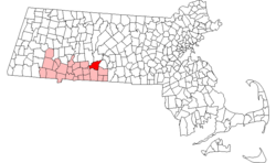 Location in Hampden County in Massachusetts | ||
 Palmer, Massachusetts Location in the United States | ||
| Coordinates: 42°09′30″N 72°19′45″W / 42.15833°N 72.32917°WCoordinates: 42°09′30″N 72°19′45″W / 42.15833°N 72.32917°W | ||
| Country | United States | |
| State | Massachusetts | |
| County | Hampden | |
| Settled | 1727 | |
| Incorporated | 1775 | |
| Government | ||
| • Type | Council-manager | |
| • Councilors-at-large |
Paul Burns, Council President Michael Magiera, Karl, Williams, Eric Duda, William Hielman, District Councilors, Barbara Barry, Phil Hebert, Raymond Remillard and Roger Duguay | |
| • Town Manager | Matthew Streeter | |
| Area | ||
| • Total | 32.0 sq mi (82.9 km2) | |
| • Land | 31.5 sq mi (81.7 km2) | |
| • Water | 0.5 sq mi (1.3 km2) | |
| Elevation | 330 ft (101 m) | |
| Population (2000) | ||
| • Total | 12,497 | |
| • Density | 396.3/sq mi (153.0/km2) | |
| Time zone | Eastern (UTC-5) | |
| • Summer (DST) | Eastern (UTC-4) | |
| ZIP code | 01069 | |
| Area code(s) | 413 | |
| FIPS code | 25-52105 | |
| GNIS feature ID | 0619387 | |
| Website | Town of Palmer, Massachusetts | |

Palmer is a city in Hampden County, Massachusetts, United States. The population was 12,140 at the 2010 census. It is part of the Springfield, Massachusetts Metropolitan Statistical Area. Palmer adopted a home rule charter in 2004 with a council-manager form of government. Palmer is one of fourteen Massachusetts municipalities that have applied for, and been granted, city forms of government but wish to retain "The town of” in their official names.[2]
The villages of Bondsville, Thorndike, Depot Village, and Three Rivers are located in the town.
History
Palmer is composed of four separate and distinct villages: Depot Village, typically referred to simply as "Palmer" (named for the ornate Union Station railroad terminal designed by architect Henry Hobson Richardson), Thorndike, Three Rivers, and Bondsville. The villages began to develop their distinctive characters in the 18th century, and by the 19th century two rail lines and a trolley line opened the town to population growth. Today, each village has its own post office, and all but Thorndike have their own fire station.
Palmer was originally a part of Brimfield but separated after being too far from Brimfield. Palmer's first settler was John King. King was born in Edwardstone, Suffolk, England, and built his home in 1716 on the banks of the Quaboag River. The area as then known was called "The Elbow Tract". In 1731, a deed to land in today's Palmer renamed the town 'New Marlborough' after Marlborough, Massachusetts in today's Middlesex County. In 1731, residents of the borough renamed the town 'Kingsfield', after the aforementioned John King. Though in some papers in the Massachusetts General Court, it was referred to as the Elbow. A large group of Scots-Irish Presbyterians followed, arriving in 1727. Finally in 1752, it was named Palmer after Chief Justice Palmer. In 1775, Massachusetts officially incorporated Palmer.[3][4]
Depot Village became Palmer's main commercial and business center during the late 19th century and remains so today. Palmer's industry developed in Bondsville. During the 18th century, saw and grist mills were established by the rivers, and by 1825 Palmer woolen mills began to produce textiles. The Blanchard Scythe Factory, Wright Wire Woolen Mills, and the Holden-Fuller Woolen Mills developed major industrial capacity, and constructed large amounts of workers' housing. By 1900, Boston Duck (which made heavy cotton fabric) had over 500 employees in the town. The 20th century brought about a shift of immigrants in Palmer from those of French and Scottish origin to those of primarily Polish and French-Canadian extraction.
Fire and water districts
Unlike many Massachusetts communities, The Town of Palmer does not have its own water department. Instead Palmer, Bondsville and Three Rivers each have their own water department and their own fire department. Each fire department has its own fire chief, as there is no town-wide chief. Thorndike does not have its own fire department or water department instead contracting out with Palmer. The Thorndike Fire Department was disbanded following World War II.
Geography
According to the United States Census Bureau, the town has a total area of 32.0 square miles (82.9 km²), of which 31.5 square miles (81.7 km²) are land and 0.5 square mile (1.3 km²) (1.53%) is water. The town is bordered by Ludlow and Wilbraham on the southwest, Belchertown on the northwest, Ware on the northeast, Warren on the east, Brimfield on the southeast, and Monson on the south.
Demographics
| Historical population | ||
|---|---|---|
| Year | Pop. | ±% |
| 1850 | 3,974 | — |
| 1860 | 4,082 | +2.7% |
| 1870 | 3,631 | −11.0% |
| 1880 | 5,504 | +51.6% |
| 1890 | 7,520 | +36.6% |
| 1900 | 7,801 | +3.7% |
| 1910 | 8,610 | +10.4% |
| 1920 | 9,896 | +14.9% |
| 1930 | 9,677 | −2.2% |
| 1940 | 9,149 | −5.5% |
| 1950 | 9,533 | +4.2% |
| 1960 | 10,358 | +8.7% |
| 1970 | 11,680 | +12.8% |
| 1980 | 11,389 | −2.5% |
| 1990 | 12,054 | +5.8% |
| 2000 | 12,497 | +3.7% |
| 2010 | 12,140 | −2.9% |
| 2014 | 12,174 | +0.3% |
| * = population estimate. Source: United States Census records and Population Estimates Program data.[5][6][7][8][9][10][11][12][13][14] Source: | ||
As of the census[16] of 2000, there were 12,497 people, 5,078 households, and 3,331 families residing in the town. The population density was 396.3 people per square mile (153.0/km²). There were 5,402 housing units at an average density of 171.3 per square mile (66.2/km²). The racial makeup of the town was 96.82% White, 0.75% Black or African American, 0.23% Native American, 0.56% Asian, 0.44% from other races, and 1.19% from two or more races. Hispanic or Latino of any race were 1.23% of the population.
There were 5,078 households out of which 31.6% had children under the age of 18 living with them, 48.5% were married couples living together, 12.3% had a female householder with no husband present, and 34.4% were non-families. 28.7% of all households were made up of individuals and 13.0% had someone living alone who was 65 years of age or older. The average household size was 2.45 and the average family size was 3.01.
In the town the population was spread out with 25.2% under the age of 18, 6.8% from 18 to 24, 30.5% from 25 to 44, 22.0% from 45 to 64, and 15.5% who were 65 years of age or older. The median age was 38 years. For every 100 females there were 93.5 males. For every 100 females age 18 and over, there were 88.9 males.
The median income for a household in the town was $41,443, and the median income for a family was $49,358. Males had a median income of $35,748 versus $26,256 for females. The per capita income for the town was $18,664. About 5.8% of families and 7.9% of the population were below the poverty line, including 10.3% of those under age 18 and 9.8% of those age 65 or over.
Economy
Future development
The New England Region of the Sports Car Club of America has reached an agreement with the Town of Palmer to construct a new road course near their town. Palmer Motorsports Park will operate along a similar vein as Buttonwillow Raceway Park in California, in that it will be owned and operated by a limited liability corporation formed by New England Region. This effort is to ensure that NER would have its own "flagship" racetrack, as the two tracks it currently uses – New Hampshire Motor Speedway and Lime Rock Park in Connecticut – are heavily used by NASCAR. The benefits to the town would include upwards of $50,000 a year in property income taxes and increased business at local gas stations, restaurants, motels and retail stores.
Palmer Motor Sports Park opened for racing in May 2015. It is a 2.3 mile road course with over 190 feet in elevation change. Road & Track magazine named Palmer Motorsports Park one of the top 10 racetracks to drive in North America.
Business advocacy
The Quaboag Hills Chamber of Commerce is headquartered in Palmer and is the advocate for business and community development in the Quaboag Valley area by providing the 200+ members with a voice in political, social and economic issues.[17]
Arts and culture
Camp Ramah in New England is located in Palmer.
Education
The town of Palmer is served by four schools. Old Mill Pond Elementary School serves grades K through 4, Converse Middle School serves grades 5 through 7, and Palmer High School serves grades 8 through 12. Pathfinder Regional Vocational Technical High School is also located in Palmer, and serves grades 9 through 12.
Infrastructure
Railroads
Palmer has been called the "Town of Seven Railroads". These included five operating railroads (Boston & Albany, Central Vermont, Springfield, Athol & Northeastern, Ware River, and Central Massachusetts), one which was built but never operated (Hampden), and one which was not completed (Southern New England) The B&A, CV, and Ware River served Union Station, which was designed by H. H. Richardson.
The Central Vermont was sold to RailTex in 1995 and operated as the New England Central Railroad. RailTex was merged into RailAmerica in 2000, which in turn was acquired by the Genesee & Wyoming company in 2012. The B&A is now the CSX Boston Subdivision, while parts of the otherwise defunct Ware River and Central Massachusetts are operated by the Massachusetts Central Railroad. The SA&N was abandoned in the 1930s when the Quabbin Reservoir was built.
Amtrak's Lake Shore Limited passes through Palmer, as did the Montrealer from 1989 to 1995 and the Vermonter from 1995 to 2014, but no trains have stopped at Palmer since 1971. Union Station is privately owned and houses a restaurant.
Notable person
- Chuck Thompson, sportscaster
See also
References
- ↑ "Town of Palmer, Massachusetts". Town of Palmer, Massachusetts. Retrieved August 29, 2012.
- ↑ http://www.sec.state.ma.us/cis/cisctlist/ctlistalph.htm
- ↑ "Palmer, Massachusetts". City-data.com. Retrieved August 29, 2012.
- ↑ "Profile for Palmer, Massachusetts, MA". ePodunk. Retrieved August 96, 2012. Check date values in:
|access-date=(help) - ↑ "TOTAL POPULATION (P1), 2010 Census Summary File 1". American FactFinder, All County Subdivisions within Massachusetts. United States Census Bureau. 2010.
- ↑ "Massachusetts by Place and County Subdivision - GCT-T1. Population Estimates". United States Census Bureau. Retrieved July 12, 2011.
- ↑ "1990 Census of Population, General Population Characteristics: Massachusetts" (PDF). US Census Bureau. December 1990. Table 76: General Characteristics of Persons, Households, and Families: 1990. 1990 CP-1-23. Retrieved July 12, 2011.
- ↑ "1980 Census of the Population, Number of Inhabitants: Massachusetts" (PDF). US Census Bureau. December 1981. Table 4. Populations of County Subdivisions: 1960 to 1980. PC80-1-A23. Retrieved July 12, 2011.
- ↑ "1950 Census of Population" (PDF). Bureau of the Census. 1952. Section 6, Pages 21-10 and 21-11, Massachusetts Table 6. Population of Counties by Minor Civil Divisions: 1930 to 1950. Retrieved July 12, 2011.
- ↑ "1920 Census of Population" (PDF). Bureau of the Census. Number of Inhabitants, by Counties and Minor Civil Divisions. Pages 21-5 through 21-7. Massachusetts Table 2. Population of Counties by Minor Civil Divisions: 1920, 1910, and 1920. Retrieved July 12, 2011.
- ↑ "1890 Census of the Population" (PDF). Department of the Interior, Census Office. Pages 179 through 182. Massachusetts Table 5. Population of States and Territories by Minor Civil Divisions: 1880 and 1890. Retrieved July 12, 2011.
- ↑ "1870 Census of the Population" (PDF). Department of the Interior, Census Office. 1872. Pages 217 through 220. Table IX. Population of Minor Civil Divisions, &c. Massachusetts. Retrieved July 12, 2011.
- ↑ "1860 Census" (PDF). Department of the Interior, Census Office. 1864. Pages 220 through 226. State of Massachusetts Table No. 3. Populations of Cities, Towns, &c. Retrieved July 12, 2011.
- ↑ "1850 Census" (PDF). Department of the Interior, Census Office. 1854. Pages 338 through 393. Populations of Cities, Towns, &c. Retrieved July 12, 2011.
- ↑ "Census of Population and Housing". Census.gov. Retrieved June 4, 2015.
- ↑ "American FactFinder". United States Census Bureau. Retrieved 2008-01-31.
- ↑ "The Quaboag Hills Chamber of Commerce Mission Statement". Retrieved 2013-09-23.
External links
| Wikimedia Commons has media related to Palmer, Massachusetts. |
- Town website
- Home rule charter of Palmer
- Massachusetts official website – Town of Palmer
- DCR Palmer Reconnaissance Report
 Chisholm, Hugh, ed. (1911). "Palmer, Massachusetts". Encyclopædia Britannica (11th ed.). Cambridge University Press.
Municipalities and communities of Hampden County, Massachusetts, United States | ||
|---|---|---|
| Cities | 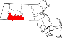 | |
| Towns | ||
| CDPs | ||
| Other villages | ||
| Footnotes | ‡This populated place also has portions in an adjacent county or counties | |