Pakuranga
| Pakuranga | |
|---|---|
 Pakuranga, looking east (the suburb is the "peninsula"-shape on the far side of the Tamaki River) | |
 | |
| Basic information | |
| Local authority | Auckland Council |
| Population | 30,340 (2006) |
| Surrounds | |
| North | (Tamaki River), Glen Innes |
| Northeast | Sunnyhills |
| East | Botany |
| Southeast | East Tamaki |
| South | (Tamaki River) |
| Southwest | (Tamaki River), Otahuhu |
| West | (Tamaki River), Mount Wellington |
| Northwest | (Tamaki River), Panmure |
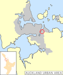
Pakuranga is an eastern suburb of Auckland, in northern New Zealand. Pakuranga covers a series of low ridges and previously swampy flats, now drained, that lie between the Pakuranga Creek and Tamaki River, two estuarial arms of the Hauraki Gulf. It is located to the north of Manukau and 15 kilometres southeast of the Auckland CBD.
History
The suburb's name is Maori for battle of the sunlight or battle of the sun's rays. This peculiar name is the result of a legend about a battle between mythical nocturnal creatures. The battle raged fiercely until a Maori priest caused the sun to rise earlier than expected. Caught by surprise in the rays of the sun, the monsters perished.[1]
Pakuranga itself had a low Maori population in the early days due to the swampy nature of much of the land. Three prominent pa were at Pigeon Mountain and two at Panmure on a cliff, at the intersection of the Tamaki River and the inlet to the Panmure Basin. During the attacks by Ngapuhi in the Musket wars in late September 1820, most of the population were killed, eaten, taken prisoner or fled south to the Waikato.
In early European times, it was a sparsely settled dairy farming area between the townships of Panmure and Howick.[2] In the 1920s and 30s it was served by a bus that ran from Bucklands Beach known as the "shiek". In the 1930s a concrete road was built between these townships that improved transport times for people and milk. Although there had been a hinged steel bridge over the Tamaki River to Panmure from as early as 1866, it was not until the construction of a sturdier structure across the Tamaki River in the 1950s, coinciding with a demand for more settlement land[2] and the increasing levels of car ownership, that Pakuranga became suburban. In fact, for a while in the 70s it was considered the typical New Zealand middle class suburb, 'Vim Valley', after 'a typical Pakuranga housewife' was featured in a famous cleaning product ad.[2]
Many of the American style houses of the 1950s and 1960s are still noticeable but much of the appeal of the early suburb lay in the proximity of untouched countryside. Since the 1970s Pakuranga has been surrounded and engulfed by suburban developments on a much larger scale but of less architectural merit. Traffic travelling to and from these suburbs and the centre of Auckland is largely funnelled through the roadways of Pakuranga which has degraded the area somewhat as well.
Despite this today Pakuranga remains an attractive suburb, with some light industry, centred on the Pakuranga Town Centre 1965, the second built in New Zealand, now known as "The Plaza". The mall the second mall of the modern age in New Zealand, incorporating Farmers and George Court department stores.[3] The mall itself has been transformed several times since it first went up and retains little of the 1960s style it once had. The Te Tuhi Centre for the Arts is located nearby.
Schools
There was no school in the area before the 1960s so children had to walk or ride horses to the old Howick school which was located across from the Highland Park shops. The old school was moved to the old village display in Bells Rd, Pakuranga.
Pakuranga College was built on a low-lying swampy piece of land south of Pigeon Mountain opening in May 1961 with a roll of 428. Edgewater College was built on low-lying swamp land known as Fletcher's Bog near the Tamaki River. It opened in 1968. Schools in Pakuranga also include the private school Saint Kentigern College.
See also
References
- ↑ "Auckland - Pakuranga". The Band Of Her Majesty's Royal Marines. Retrieved 7 January 2011.
- 1 2 3 "Pakuranga". Te Ara: The Encyclopedia of New Zealand. Ministry for Culture and Heritage / Te Manatū Taonga. Retrieved 7 January 2011.
- ↑ "New Zealand's main malls". Te Ara: The Encyclopedia of New Zealand. Ministry for Culture and Heritage / Te Manatū Taonga. Retrieved 7 January 2011.
External links
- History of Howick and Pakuranga
- Google Map of Pakuranga
- Te Tuhi Centre for the Arts
- Photographs of Pakuranga held in Auckland Libraries' heritage collections.
Coordinates: 36°53′S 174°55′E / 36.883°S 174.917°E