Pakham District
| Pakham ปะคำ | |
|---|---|
| Amphoe | |
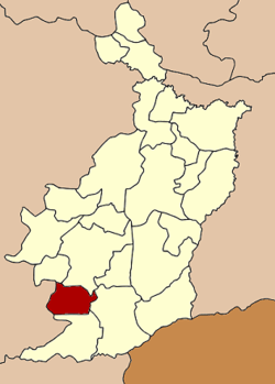 Amphoe location in Buriram Province | |
| Coordinates: 14°26′18″N 102°43′32″E / 14.43833°N 102.72556°ECoordinates: 14°26′18″N 102°43′32″E / 14.43833°N 102.72556°E | |
| Country | Thailand |
| Province | Buriram |
| Seat | Pakham |
| Area | |
| • Total | 296.029 km2 (114.297 sq mi) |
| Population (2005) | |
| • Total | 43,446 |
| • Density | 146.8/km2 (380/sq mi) |
| Time zone | ICT (UTC+7) |
| Postal code | 31220 |
| Geocode | 3112 |
Pakham (Thai: ปะคำ, pronounced [pā.kʰām]) is a district (amphoe) in the southwestern part of Buriram Province, northeastern Thailand.
Geography
Neighboring districts are (from the north clockwise) Non Suwan, Nang Rong, Lahan Sai, Non Din Daeng of Buriram Province and Soeng Sang of Nakhon Ratchasima Province.
History
The minor district (king amphoe) was created on 1 December 1978, when the three tambon Pakham, Thai Charoen, and Nong Bua were split off from Lahan Sai District.[1] It was upgraded to a full district on 15 March 1985.[2]
Administration
The district is divided into five sub-districts (tambon), which are further subdivided into 74 villages (muban). Pakham is a township (thesaban tambon) which covers parts of tambon Pakham. There are also five tambon administrative organizations (TAO).
| No. | Name | Thai name | Villages | Pop. | |
|---|---|---|---|---|---|
| 1. | Pakham | ปะคำ | 9 | 6,782 | |
| 2. | Thai Charoen | ไทยเจริญ | 14 | 6,922 | |
| 3. | Nong Bua | หนองบัว | 11 | 5,914 | |
| 4. | Khok Mamuang | โคกมะม่วง | 21 | 13,165 | |
| 5. | Hu Thamnop | หูทำนบ | 19 | 10,663 |
References
- ↑ ประกาศกระทรวงมหาดไทย เรื่อง แบ่งท้องที่อำเภอละหานทราย จังหวัดบุรีรัมย์ ตั้งเป็นกิ่งอำเภอปะคำ (PDF). Royal Gazette (in Thai). 95 (130 ง): 4082. November 21, 1978.
- ↑ พระราชกฤษฎีกาตั้งอำเภอเขาสวนกวาง อำเภอแปลงยาว อำเภอบ่อทอง อำเภอปะคำ และอำเภอบ้านฉาง พ.ศ. ๒๕๒๘ (PDF). Royal Gazette (in Thai). 102 (33 ก special): 7–9. March 15, 1985.