Pajaro River
| Pajaro River | |
| Rio de San Antonio, Rio del Pajaro | |
| stream | |
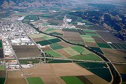 Aerial view of the Pajaro River at Watsonville, California. The river empties into the Pacific Ocean about 2.5 miles (4 km) west of this photograph. View is to the east. | |
| Country | United States |
|---|---|
| State | California |
| Region | Santa Cruz, Monterey, Santa Clara, and San Benito counties |
| Tributaries | |
| - left | Pacheco Creek, San Benito River |
| - right | Llagas Creek, Uvas Creek/Carnaderas Creek, Salsipuedes Creek |
| Source | San Felipe Lake |
| - location | 7 mi (11 km) east of Gilroy |
| - elevation | 146 ft (45 m) |
| - coordinates | 36°58′55″N 121°29′18″W / 36.98194°N 121.48833°W [1] |
| Mouth | Monterey Bay |
| - location | 5 mi (8 km) southwest of Watsonville |
| - elevation | 0 ft (0 m) |
| - coordinates | 36°51′00″N 121°48′35″W / 36.85000°N 121.80972°WCoordinates: 36°51′00″N 121°48′35″W / 36.85000°N 121.80972°W [1] |
| Length | 30 mi (48 km) |
| Basin | 1,300 sq mi (3,367 km2) |
| Discharge | for Chittenden |
| - average | 163 cu ft/s (5 m3/s) |
| - max | 25,100 cu ft/s (711 m3/s) |
| - min | 0 cu ft/s (0 m3/s) |
The Pajaro River (pájaro is bird in Spanish), in Central Coast (California), forms part of the border between San Benito County and Santa Clara County, the entire border between San Benito County and Santa Cruz County, and the entire border between Santa Cruz County and Monterey County. Flowing roughly east to west, the river empties into Monterey Bay, west of Watsonville, California.
History
The first European land exploration of Alta California, the Spanish Portolà expedition, camped near the river for two nights, in the vicinity of today's community of Pajaro, on October 8–9, 1769. The party continued north the next day toward Santa Cruz. Expedition soldiers called it "Pajaro" (meaning "bird" in Spanish) because the natives they saw there had a large stuffed bird. Franciscan missionary Juan Crespi, traveling with the expedition, noted in his diary that, "to some of our party it looked like a royal eagle" (possibly an osprey).[2]

The Pajaro River has had many names. Early Spanish maps had the name Rio de San Antonio and Rio del Pajaro.[3] Alternate names included Pigeon River, Rio de La Senora La Santa Ana, Rio del Paxaro, Rio de Santa Ana, San Antonio River and Sanjon del Tequesquite.[3]
In 1953 the State Water Resource Control Board determined that the Pajaro Valley Watershed suffered from saltwater intrusion due to groundwater overdraft. In the 1970s, the groundwater basin consistently fell below sea level, and was identified in 1980 as critically over-drafted. By the 21st century, 54 square miles of the Pajaro Watershed's groundwater supply was overdrawn and as a result, below sea level making the area susceptible to saltwater intrusion.[4]
The Pajaro River has a recurring history of flooding. The towns of Pajaro and Watsonville were built on the river’s natural floodplain. Before the Army Corps of Engineers built the levees, flooding devastated homes, businesses, and agriculture. Since the $748,000 levees were constructed in 1949, there have been several instances of flooding from severe weather events and failed levees. In 1963, the USACE (United States Army Corps of Engineers) acknowledged poor planning in levee design, and congress authorized re-construction of the flood control system, however no funds were provided from the federal government.[5]
Following the 1995 floods, several lawsuits were issued against the different counties and cities by farmers and homeowners affected. Santa Cruz County, Monterey County, and the California Department of Transportation were all held responsible for failing to maintain the Pajaro River during floods and sued by about 250 people. Plaintiffs held the counties responsible because inn 1944, both counties made promises to maintain the levees implemented by the Army Corps of Engineers.[6]
Timeline of floods
| Date | Flooding impacts |
|---|---|
| 1890 | A severe flood was enhanced when a rail bridge’s pilings by the mouth of the river allowed for debris to accumulate and cease discharge to the ocean. As a result, the floods were remembered as the “Highest yet known” for the next 50 years.[7] |
| 1894 | Flooding near the city of Watsonville, California[7] |
| 1907 | Major flooding region wide.[7] |
| 1911 | Each year experienced overflow near the city of Watsonville.[7] |
| 1914 | |
| 1915 | |
| 1916 | |
| 1922 | |
| 1927 | |
| 1931 | |
| 1933 | |
| 1937 | |
| 1938 | Flooding |
| 1949 | (Army Corps of Engineers levee construction) |
| 1955 | Flooding |
| 1963 | Overflow near the city of Watsonville.[7] |
| 1982 | Flooding of agricultural land at Llagas Creek at the Pajaro River bordering Santa Clara and San Benito Counties. Floodwaters at the confluence of Pajaro River and Carnadero Creek flooded agricultural lands in Santa Clara and San Benito counties. The Pajaro River inundated part of Watsonville and adjacent agricultural land. High stages in the Pajaro River blocked Watsonville drainage.[7] |
| 1983 | Flooding in agricultural lands at the confluence of Pajaro River and Carnadero Creek.[7] |
| 1986 | Significant flooding on the Pajaro River in February.[7] |
| 1995 | All residences and businesses damaged; 2,500 evacuations[8]
Damage to 3,280 acres of agricultural crops along the Pajaro River were estimated at $67 million, and urban damages in Pajaro estimated at $28 million. Two persons drowned[7] |
| 1997 | Flooding |
| 1998 | Town of Pajaro evacuated.[8] The levee along the Pajaro River was breached in several places, and a Presidential disaster was declared.[7] |
Geology
The San Andreas Fault line crosses the Pajaro River at the Pajaro Gap near Aromas, California and California State Route 129.[9] The Salinian Block rests above the Pacific Platewhich slips north along the San Andres Fault. It is made up of granitic material, and marine sediments.[10]
The Pajaro River has a history of changing its course due to the San Andreas fault slippage between the Pacific plate and the North American Plate. At another time it flowed into the Elkhorn Slough in Moss Landing, California then into the Pacific Ocean, but today it joins with Corralitos Creek to discharge into the Pacific at a slightly more north location.[11]
The 1989 Loma Prieta earthquake in the Santa Cruz Mountains deformed the Pajaro levee system.[11]
Other faults within the watershed are the Zayante fault, Sargent Fault, and Calaveras fault.[11]
A.R. Wilson Granite Rock quarry is located by the Pajaro gap adjacent to the river in San Benito county.[12]
Geography
Due to the geology in the area, the geomorphology of the watershed is unique. The river begins at Diablo range in the east. In the south, from the Gabilan mountains flows another tributary northward. From the north, tributaries flow from the Santa Cruz mountains southward to meet with the Pajaro.
Climate
Climate in the region is Mediterranean. Watsonville annual high temps reach 68 °F and lows of 47 °F. The average temperature is around 57 °F and average precipitation in the form of rainfall is about 23.5 inches.[13]
Certain tributaries frequently run dry due to a lack of rainfall in the summer.
Watershed
The watershed is approximately 1,300 square miles (3,400 km2) and covers portions of Santa Cruz, Santa Clara, San Benito, and Monterey Counties.[14] The Pajaro River mainstem begins just west of San Felipe Lake,[15] also called Upper Soap Lake, which is a permanent natural lake formed by the confluence of Pacheco Creek, Tequisquita Slough and Ortega Creek. Pacheco Creek's headwaters are in the Diablo Range at about 400 feet (120 m) elevation. The Pajaro River mainstem flows west for 30 miles (50 km), passing the city of Watsonville and emptying into Monterey Bay. Lower Soap Lake, also called Soap Lake, is an intermittent body of water a few miles downstream of the upper lake. This type of water body forms when the channel below is unable to keep up with the flow coming from upstream. The San Andres Fault divides the watershed and is responsible for altering historical flow paths.[16]
Upper Watershed
San Felipe Lake lies just south of the Santa Clara County line in San Benito County, just south of Highway 152 east of Gilroy at the foot of the Diablo Range. The lake is a sag pond dammed by the fault scarp of the Calaveras Fault, which forms a natural dike along the western shoreline. It is perennial in all but the driest years, e.g. 1977.[17] San Felipe Lake used to be 50% larger until the man-made North and South Outflow canals, which drain to the Miller Canal, were cut through the western rim in 1874.[18]
The Pajaro River's largest tributary is the San Benito River which is much longer than the Pajaro, flowing northwest from its source at an elevation of 4,760 feet on San Benito Mountain on its course between the Diablo Range and the Gabilan Range, traveling for about 65 miles (105 km) before its confluence with the Pajaro River, about 15 miles (24 km) upstream from the ocean. The lowest tributary of the Pajaro River is Salsipuedes Creek which drains the Corralitos Creek and Salsipuedes Creek sub-basins.
Lower Watershed
The lower watershed is in Santa Cruz and Monterey Counties which currently have levee systems. The original river system was Corralitos Creek, fed by Aromas Creek. The Pajaro river has taken over this system, and Corralitos Creek is now only a tributary.[16]
A residential development, agricultural fields, and Zmudowski State Beach border the Pajaro River mouth and the connecting Watsonville Slough. The river mouth is often open to tidal action for extended periods, especially during the winter months. Should the mouth fill with sediment, it must be physically reopened to prevent nearby agricultural fields from flooding.[19]
The main water source for agriculture and drinking water in the region comes from groundwater. The three primary aquifers in the Pajaro Watershed are the Alluvial, the Aromas, and the Purisma aquifers. All three suffer from seawater intrusion due to groundwater overdraft, the worst affected being the Aromas aquifer.The Alluvial aquifer is heavily polluted by agricultural runoff.[20]
Ecology
In 2006, the Pajaro River was designated as America's most endangered river by the American Rivers organization, due to levees constructed by the Army Corps of Engineers along its lower 22 miles (35 km) and severe runoff into the river from agricultural fields.[21]
Native California fish present in the lower Pajaro River are: Inland Threespine Stickleback (Gasterosteus aculeatus microcephalus), Sacramento Perch (Archoplites interruptus), Riffle Sculpin (Cottus gulosus), Sacramento Tule Perch (Hysterocarpus traskii traskii), South Central California Coast Steelhead (Oncorhynchus mykiss), and Thicktail Chub (Siphatales crassicauda).[22]
Four species are listed as threatened or endangered under the federal ESA that are present or for which suitable habitat exists in or adjacent to the Pajaro River. Steelhead trout, the California red-legged frog, the tidewater goby, and the snowy plover, which nests at the Pajaro river mouth at Zumdowski State Beach at the Pacific Ocean.[23]
There are six species listed as threatened or California species of special concern (SSC) under the CESA that regularly occur and/or breed near or in the Pajaro River. Western pond turtles, Pallid bat, Burrowing owls, San Francisco Dusky-footed Woodrat, Least Bell’s vireo, and the Yellow-breasted chat.[23]
San Felipe Lake, which is the central feature of the “Bolsa de San Felipe”, is designated as a “California Important Bird Area” by the National Audubon Society. The Bolsa is a crossroads for birds migrating between San Francisco Bay to the north, Monterey Bay to the west and the Central Valley to the east. The Bolsa is also identified by the National Audubon Society as a “bird vagrant trap”, a site where bird species far outside of their normal range appear.[14]
The Pajaro River serves as a migration pathway for adult Steelhead trout (Oncorhynchus mykiss) migrating to spawning and nursery habitat in the upper watershed creeks (Uvas, Llagas and Corralitos), although the Pajaro River mainstem provides poor spawning and rearing habitat due to low summer flows and high sedimentation loads. Coho salmon (Oncorhyncus kisutch) have not been present in the river since at least the late 1960s.[14]
Historically it is interesting as one of two Northern California coastal rivers mentioned in 1829 by Russian explorer K. T. Khlebnikov as hosting sturgeon, presumably White sturgeon (Acipenser transmontanus), along with the Russian River.[24]
Also noteworthy is perhaps the southernmost record of North American river otter (Lontra canadensis) in a California coastal watershed. In 1969 river otter were recorded eating freshwater mussels (California floater (Anodonta californiensis)) on the Santa Ana Creek tributary of Tequisquita Slough, 2 miles east of Hollister.[25]
Water Quality
The river is heavily polluted by people dumping illegally. One cleanup in 2015 revealed over 1,000 tires, five boats, two trucks, and tons of trash.[26]
High toxicity levels in the river are a result from agriculture in the watershed. During low flows, organophosphate pesticides have been detected in the river, and organochlorine pesticides have been detected post-high surface runoff events. Toxaphene, DDT, and Diazinon have also been detected at concentrations unhealthy to local aquatic species.[27]
Improvements
In 2010 the City of Watsonville was awarded a $424,000 grant to create a public access point for canoes and kayaks, including a parking lot, trail, and public restrooms.[28][29]
The Pajaro River CARE project was funded by the California Natural Resources Agency.[30]
The Pajaro River Watershed Integrated Regional Water Management Plan (IRWMP) is a movement by the Pajaro Valley Water Management Agency (PVWMA), San Benito County Water District (SBCWD), and Santa Clara Valley Water District (SCVWD) to join together in order to create and benefit the watershed as a whole.[23]
The Pajaro River Bench Excavation Project which was approved in 2012 will remove excess sediment and vegetation from the bench in order to better allow flow through the levees to improve flood protection. Approximately 336,000 cubic yards will be removed. The project begins at Murphy’s crossing, and extends 7.5 miles westward to the Pacific Ocean ending before highway 1.[31]
The state of California allocated $7.6 million to the Pajaro watershed to pay for water projects. One project funded was the building of two 1 million gallon storage tanks for the waste water recycling plant which provides water to local agriculture in the Valley.[32]
In early 2015, a land purchase in the upper Pajaro Watershed was purchased by Santa Clara Valley Open Space Authority in an effort to preserve agriculture, and increase floodplain and wildlife protection in Santa Clara County. This land is where Llagas Creek and the Pajaro River intersect, with about 183 total acres. The intention is to leave the land undeveloped, thereby reducing risk of flooding for the lower watershed. It’s also intended to preserve and restore habitat corridors linking the Santa Cruz, Gabilan, and Mt. Hamilton Ranges.[33]
References
- 1 2 U.S. Geological Survey Geographic Names Information System: Pajaro River
- ↑ Bolton, Herbert E. (1927). Fray Juan Crespi: Missionary Explorer on the Pacific Coast, 1769-1774. HathiTrust Digital Library. pp. 208–209. Retrieved April 2014. Check date values in:
|access-date=(help) - 1 2 David L. Durham (2000). Durham's place names of California's Central Coast: includes Santa Barbara, San Luis Obispo, San Benito, Monterey & Santa Cruz counties. Quill Driver Books. p. 143. ISBN 978-1-884995-29-3. Retrieved 2010-07-05.
- ↑ "The Pajaro River Watershed : Content: History and Background". www.pajarowatershed.org. Retrieved 2016-05-05.
- ↑ Warner, Keith (2001). "Flooding and Fragmentation: How Physical Features Structure Political Conflict Over Flood Control in California's Pajaro Valley" (PDF). APCG YEARBOOK.
- ↑ Press, From Associated (1998-08-08). "Victims of 1995 Flood Win Lawsuit". Los Angeles Times. ISSN 0458-3035. Retrieved 2016-05-12.
- 1 2 3 4 5 6 7 8 9 10 "California's Flood Future Recommendations for Managing the State's Flood Risk" (PDF). Department of Water Resources. 2013. Retrieved April 23, 2016.
- 1 2 "Historical Flooding". www.mcwra.co.monterey.ca.us. Retrieved 2016-04-23.
- ↑ "Interactive Map of the San Andreas Fault - Thule Scientific". www.thulescientific.com. Retrieved 2016-04-23.
- ↑ "MBNMS Site Characterization: Geology - III. Geology and Tectonics". montereybay.noaa.gov. Retrieved 2016-04-23.
- 1 2 3 "The Pajaro River Watershed : Content: Geologic Setting". www.pajarowatershed.org. Retrieved 2016-04-23.
- ↑ "Graniterock: Concrete, Building Materials, Contracting & Construction Services". www.graniterock.com. Retrieved 2016-04-23.
- ↑ Data, US Climate. "Climate Watsonville - California and Weather averages Watsonville". www.usclimatedata.com. Retrieved 2016-04-23.
- 1 2 3 "Pajaro River Watershed Integrated Regional Water Management Plan Work Plan" (PDF). May 2005. Retrieved 2010-07-05.
- ↑ "San Felipe Lake". Geographic Names Information System. United States Geological Survey.
- 1 2 "The Pajaro River Watershed : Content: Geologic Setting". www.pajarowatershed.org. Retrieved 2016-05-05.
- ↑ Casagrande, Julie Renee (2010). Aquatic Ecology of San Felipe Lake, San Benito County, California. Master's Theses. Paper 3803. (Thesis). San Jose State University. Retrieved 2012-12-02.
- ↑ Jones, Donna (February 2, 2010). "P.V. water agency eyes new rates, pipeline". Santa Cruz Sentinel. Retrieved 1 February 2016.
- ↑ "The Pajaro River" (PDF). The Trust for Public Land. Retrieved 2010-07-05.
- ↑ "The Pajaro River Watershed : Content: Water Quality". www.pajarowatershed.org. Retrieved 2016-05-05.
- ↑ "America's Most Endangered Rivers of 2006" (PDF). American Rivers. 2006. Retrieved 2010-07-05.
- ↑ Resources, University of California, Division of Agriculture and Natural. "Fish Species by Location". calfish.ucdavis.edu. Retrieved 2016-05-12.
- 1 2 3 "Pajaro River Watershed Integrated Regional Water Management Plan". ValleyWater.org. Retrieved March 13, 2016.
- ↑ K. T. Khlebnikov (1940). "Memoirs of California". Pacific Historical Review. 9: 307–336. doi:10.2307/3632910. JSTOR 3632910.
- ↑ D. Victor Morejohn (1969). "Evidence of River Otter Feeding on Freshwater Mussels and Range Extension". California Fish and Game. 55 (2): 83–85.
- ↑ Cortez, Felix. "Drought revels junk at bottom of Pajaro River". KSBW. Retrieved 2016-04-23.
- ↑ Hunt, John (1999). "Patterns of aquatic toxicity in an agriculturally dominated coastal watershed in California" (PDF). Elsevier Science.
- ↑ Public Works, Watsonville. "River Access". City Website. Retrieved 8 April 2011.
- ↑ J. Chown. "City awarded grant to improve river access". Register Pajaronian. Retrieved 8 April 2011.
- ↑ "Pajaro River CARE Project | City of Watsonville, CA". cityofwatsonville.org. Retrieved 2016-05-11.
- ↑ "Pajaro River Bench Excavation Project" (PDF). County of Santa Cruz, Planning Department. 2012.
- ↑ "Pajaro River watershed in line for $7.6 million state grant". www.santacruzsentinel.com. Retrieved 2016-05-12.
- ↑ "Key Land Purchase along Upper Pajaro River Preserves Agriculture, Floodplain Protection, and Wildlife in Santa Clara County" (PDF).
External links
- Pajaro River Watershed Flood Prevention Authority
- Columbia Gazetteer of North America
- Pajaro Watershed Web Portal