Pago Pago Harbor
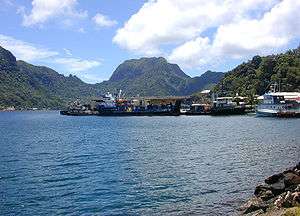
Pago Pago Harbor is a large natural inlet in the central south coast of the island of Tutuila in American Samoa. The capital, Pago Pago is located on the inner reaches of the harbor, close to its northwesternmost point.
A significant amount of debris and oil were dumped into Pago Pago Harbor during the 2009 Samoa earthquake and tsunami, which devastated communities along the harbor's coastline, including Pago Pago.[2] Debris including cars, household items, and boats were thrown into the harbor by the force of the wave.[2] According to the 14-page American Samoan government report, Post-Tsunami Coastal Resource Damage Assessment, "The inner section of Pago Pago Harbor is severely polluted and will require an extensive cleanup program with a significant amount of manpower ... The destruction is everywhere."[2]
An oil spill approximately 40 feet wide occurred at the mouth of Pago Pago Harbor as a result of the tsunami.[2] Barrels containing fuel were thrown into the harbor by the tsunami and washed up on shore.[2]
It is suggested that one must avoid eating any fish or invertebrate caught in Pago Pago Harbor because they are contaminated with heavy metals and other pollutants.[3]
References
- ↑ Archived October 3, 2009, at the Wayback Machine.
- 1 2 3 4 5 "Coral Reef Advisory tsunami report focuses on extensive marine and coastal debris". Samoa News. 2009-10-07. Retrieved 2009-10-07.
- ↑ "Natural History Guide To American Samoa". nps.org. Retrieved 2007-02-16.
Coordinates: 14°16′34″S 170°40′34″W / 14.276°S 170.676°W