Paddington, New South Wales
| Paddington Sydney, New South Wales | |||||||||||||
|---|---|---|---|---|---|---|---|---|---|---|---|---|---|
 | |||||||||||||
| Population | 12,134 (2011 census)[1] | ||||||||||||
| • Density | 8,090/km2 (21,000/sq mi) | ||||||||||||
| Postcode(s) | 2021 | ||||||||||||
| Area | 1.5 km2 (0.6 sq mi) | ||||||||||||
| Location | 3 km (2 mi) east of Sydney CBD | ||||||||||||
| LGA(s) | |||||||||||||
| State electorate(s) | Sydney | ||||||||||||
| Federal Division(s) | Wentworth | ||||||||||||
| |||||||||||||
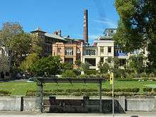
Paddington is an inner-city, eastern suburb of Sydney, in the state of New South Wales, Australia. Located 3 kilometres east of the Sydney central business district, Paddington lies across two local government areas. The portion south of Oxford Street lies within the City of Sydney, while the portion north of Oxford Street lies within the Municipality of Woollahra.[2] It is often colloquially referred to as "Paddo".
Paddington is bordered to the west by Darlinghurst, to the east by Centennial Park and Woollahra, to the north by Edgecliff and Rushcutters Bay and to the south by Moore Park.
History
Aboriginal People
The suburb of Paddington is considered to be part of the region associated with the stories of the Cadigal people. These people belonged to the Dharug (or Eora) language group, which includes what is now known as the Sydney central business district. It is known that the ridge, being the most efficient route, on which Oxford Street was built was also a walking track used by Aboriginal people. Much of the Aboriginal population (estimated at the time to be ca. 1000 people) of Sydney died due to the smallpox outbreak of 1789, one year after the First Fleet arrived in Sydney. Some Anthropologists maintain that the tribe moved to other areas of the shared Eora language group. At the time when Robert Cooper began to build his first house in Paddington, approximately 200 Koori people were living in Woolloomooloo in housing which Governor Macquarie had built for them.[3]
Paddington has never been a suburb with a dense indigenous population. In the 1930s, when parts of Sydney such as Redfern and Glebe became hubs for Aborigines entering the labour force, Paddington continued to be a European working-class suburb.
European settlement

- 1788-1800
In 1788 the First Fleet arrived in Sydney Harbour and established a settlement in Sydney Cove. Three kilometres to the east lay the land that would become Paddington. With a high sandstone ridge, eroded by streams leading to a marshy rush-filled cove too sallow for ships, the area was ignored by the newcomers, except for collecting rushes for thatch.[4]
- 1801-1840
On a path used by local Aboriginal people, a road of some form was built by Governor Hunter to South Head as early as 1803. Governor Macquarie upgraded the road in 1811 for strategic purposes to accommodate wheeled vehicles. The road was improved by Major Druitt in 1820 to give faster access to the signal station at South Head. It was also to give access to the salubrious villas built by the colony's emerging plutocracy. The road was renamed the Old South Head Road after construction of New South Head Road along the Harbour foreshore was begun in 1831.[5]
The first land grant in the Paddington area, of 100 acres (40.4 hectares), was made to Robert Cooper, James Underwood, and Francis Ewen Forbes by Governor Brisbane in 1823, allowing them to commence work on the Sydney distillery at the eastern end of Glenmore Road. A mill was located at the end of Gordon Street and run by the Gordon family grinding wheat from the early 1830s. It remained a prominent feature of the local landscape as houses were built, and as wind power was replaced by steam.[6]
Cooper built his mansion, Juniper Hall, on the South Head Road ridge while Underwood built his house on Glenmore Road, between today's Soudan Lane and the former distillery. The suburb's name came about when in October 1839 James Underwood subdivided 50 of his 97 acres. He called his subdivision the Paddington Estate after the London Borough of that name. It extended from Oxford Street down to present day Paddington Street.[5]
1841-1900

After the commencement in 1841 of Victoria Barracks the village of Paddington soon emerged, much of it around the cottages of the many artisans –stonemasons, quarrymen, carpenters and labourers – who were working on the construction of the Barracks. What emerged was a clear class distinction; the working-class located largely on or near the South Head Road and the emerging gentry living in villas facing the harbour in 'Rushcutters Valley'.[5]
Rapid growth followed, with large estates being subdivided for speculative terrace style housing. In 1862 there were 535 houses with 2,800 residents. By 1883 the number of houses increased to 2,347. In 1871 Paddington's population density was 10.2 people per acre. By 1891 it had jumped 44.1.[7]
- 1901-2000
_(7558810352).jpg)
In the first decade of the twentieth century Paddington was in its prime, with the population reaching 26,000 living in 4,800 houses. General health improved with the area being sewered.[7]
The First World War left a legacy of social problems, tensions and alcohol abuse. Paddington suffered death rates of 5 per 1000 residents in the influenza epidemic of 1919. Developers were disparaging about densely populated areas like Paddington, describing them as unhealthy, and promoting sanitised garden suburbs such as Haberfield. In Paddington the unskilled, those with a trade and those renting were hit hard during the Depression, with 30% unemployment.[7]
The post-war County of Cumberland planning scheme for metropolitan Sydney slated Paddington as a slum ripe for total redevelopment. A 1947 map titled 'Paddington Replanning' proposed demolition of virtually all existing housing to be replaced by blocks of flats.[8] However, with the newly arrived migrants from Europe finding Paddington affordable and a convenient place to live, slum clearance faded from the political agenda. In the 1960s, a middle class 'Bohemian' invasion began and Paddington became very 'muli-cultural'.[7]
From 1960 many professional people, many who may have returned from living abroad, recognised Paddington's potential, particularly the suburb's close proximity to the CBD. With the restoration of often derelict houses there developed a new awareness and interest in the historical and aesthetic qualities of the area. In 1968 in a complete reversal of planning and housing orthodoxy at the time, four hundred acres of terrace housing was rezoned as the first conservation area in Australia.[9] The resident action group, the Paddington Society, founded in 1964, was a catalyst in this development.
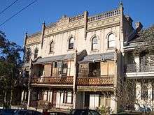
Heritage Conservation Status of PaddingtonPaddington is a rare and largely intact example of an early Victorian residential suburb. Its unique qualities may be attributed to its close proximity to the city, the topography of its harbour location, the process of development and subdivision of early land grants, and the short period in the late l9thC in which it was largely built out.
The distinctly Australian 'terrace' evolved from earlier Georgian and Regency models to form an exceptionally cohesive dormitory suburb. The heritage conservation status of Paddington its streets and houses, its rooms and details is recognised as being of National and State significance.
With this conservation status comes an obligation for all generations to look after the place, in all its detail, so as to retain its cultural and heritage significance for future generations. We are but custodians of our heritage.[10] Source: The Paddington Society
The aforementioned preservation of prominent Victorian architecture has drawn comparisons to London. In 1996, one travel journalist visiting Sydney for The New York Times noted, "in a city often said to look Californian–indeed, the 1920's California bungalow is a common type of suburban home–Paddington, also knownas Paddo, more closely resembles parts of London, particularly given the predominance of the London terrace".[11]
Commercial areas

Commercial activity in Paddington is diverse and can be divided into a number of precincts:
Oxford Street
Oxford Street is a one kilometre long shopping strip extending unbroken the length of Paddington, at least on the north side of the street. While there is a range of speciality shops and cafes, it is the plethora of clothing boutiques that has put Oxford Street on the tourist map. Bookstores and cinema are located at the Darlinghurst end, while pop-up shops and personal services, hair, nails and massage, are becoming more prevalent closer to Woollahra. With AM and PM bus lanes in operation on week days along Oxford Street, lack of parking is an issue for retailers, as are the high rents. Since around 2000, low-rise retail/office developments, such on the former site of the Royal Hospital for Women, have complemented the 19th century scale of Oxford Street, unlike the bulky multi-storey Telstra overseas communications building that opened in 1960.
Paddington Markets
The Paddington Markets has been held every Saturday in the grounds of the heritage-listed Paddington Uniting Church on Oxford Street since 1973. The market was established to persuade local craftspeople, designers of fashion, artists and jewellery makers to display and sell their wares.

William Street
William Street off Oxford Street, is where an eclectic bunch of designers and traders sell their wares from the tiny shops and terrace houses. The William Street Festival has been held every September since 2009.
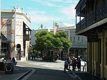
Five Ways
Five Ways is an intersection with a village atmosphere located in the northern, harbour facing part of Paddington. As well as providing for the day-to-day needs for residents, Five Ways offers a wide range of eateries with al fresco dining.
Back streets
In the leafy back streets the numerous hotels are matched by the proliferation of galleries, interior design, antique dealers and restaurants. Despite the advent of shopping malls at Bondi Junction and Edgecliff, corner shops can still be found in many streets including: Albion, Boundary, Cascade, Elizabeth, Flinders, Gordon, Hargrave, Hopetoun, McDonald, Sutherland, Regent and Underwood Streets.
Transport
.jpg)
Tram
As part of Sydney's tramway network, two tram lines ran through Paddington, one along Oxford Street, the other through Five Ways. The Oxford Street line opened in 1884 as a steam tramway to Bondi. Electric services commenced on the same line in 1902. Both lines closed in 1960.
Bus
Paddington is serviced by Sydney Buses, either along Oxford Street or through Five Ways. Oxford Street services:
- M40 Chatswood to Bondi Junction via City.
- 333 Circular Quay to Bondi Beach via Bondi Junction (express service).
- 352 Bondi Junction to Marrickville Metro via Surry Hills and Newtown.
- 378 Railway Square to Bronte via Bondi Junction.
- 380 Circular Quay to North Bondi via Bondi Beach and Bondi Junction.
Five Ways services:
- 389 Pyrmont to North Bondi via Woollahra and Bondi Junction
Bus services are also on New South Head Road between the City, Woolloomooloo, Kings Cross, Rushcutters Bay, Double Bay, Rose Bay, Vaucluse and Watsons Bay.
Rail
Paddington's closest railway station is Edgecliff, an underground railway station on the Eastern Suburbs Line of the Sydney Trains network.
Landmarks
Paddington_Town_Hall-2.jpg)
Sir Henry Parkes laid the foundation stone for the Paddington Town Hall in 1890 when Paddington was a separate municipality. It opened in 1891 and remains a distinctive example of Victorian architecture in Sydney. The clock tower is 32 metres high and being on the ridge of Oxford Street, dominates the skyline.[9]
Whilst the eastern, southern, and western faces of the clock display the conventional Roman clock-face numerals, the Roman numerals on the northern (Oxford Street) side of the clock have been replaced as follows: 1:D, 2:U, 3:S, 4:T, 5:H, 6:E, 7:VII, 8:E, 9:D, 10:V, 11:A, 12:R. This was done to celebrate the coronation of King Edward VII; and, commencing at where the VIII ought to be, the northern clock-face reads E.D.V.A.R.D.U.S T.H.E VII.[12]
The clock was officially set in motion on Wednesday, 30 August 1905, by Mr. J.H. Carruthers, the Premier of New South Wales, who mentioned in passing that "he thought that the day on which peace had been declared between Russia and Japan was a fitting time to set it in motion" and that "he hoped there would be peace and goodwill on earth as long as the clock continued to go".[13]
The building now houses radio studios, a cinema, Paddington Library, and is a venue for private functions. Paddington Town Hall was the site of a meeting of Rugby League players in 1908, at which the Eastern Suburbs Rugby League club, now the Sydney Roosters, was officially formed.

Victoria Barracks
Victoria Barracks, constructed between 1841 and 1849, is one of the best-known examples of military architecture in Australia. The sandstone buildings were designed by Lieutenant-Colonel George Barney, who also built Fort Denison and reconstructed Circular Quay. Victoria Barracks, including the museum, is open to visitors on Thursdays from 10:00 a.m. to 1.00 p.m.[14]
Sydney Cricket Ground
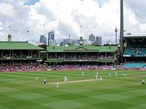
The Sydney Cricket Ground (SCG) can be accessed from Moore Park Road on Paddington's southern border. The first test match to be played at the SCG was in February 1882. The SCG is the home ground of the Sydney Swans Australian Rules Football club. Public tours are available every day except Sundays.
Sydney Football Stadium
The Sydney Football Stadium (STC or Allianz Stadium) is on Moore Park Road on Paddington's southern border. It is the home ground of the Sydney Roosters, NSW Waratahs and Sydney FC, and can be seen best from the top of Oatley Road, just outside the Paddington Town Hall.
Juniper Hall

Juniper Hall was built by Robert Cooper, an ex-convict, in the 1820s and is the oldest house in Paddington. It is a large, dominating structure located diagonally opposite the Paddington Town Hall. It underwent significant restoration when owned by the National Trust of Australia. In 2013 the building was sold to the Moran family for the Moran Arts Foundation for exhibitions and events.[15]
Oxford Street
Oxford Street was originally used as an Aboriginal walking track, then as a faster route to South Head. Trams once ran along Oxford Street to Bondi and other beaches. Once serving the needs of the local residents, the street has changed to now serve the many visitors to Paddington who come to promenade and window shop.
Paddington Reservoir

The Paddington Reservoir in Oxford street provided water to parts of Sydney between 1866 and 1899. In 2006 the remnants of the reservoir's vaulted construction were preserved with a sunken garden known as the Paddington Reservoir Gardens or Walter Read Reserve.
Trumper Park Oval
Trumper Park Oval, located at the corner of Glenmore Road & Hampden Street, is named in honour of Victor Trumper, a famous Australian test cricketer. The oval has a long history with the Australian Football East Sydney club, as well as with cricket and local athletics. A series of walking trails through a dense bushland gully connect to surrounding streets and lead to the Paddington Bowling Club and The Palms Tennis Centre.
White City Tennis Centre
The White City Tennis Centre has been a big part of Australian Tennis since its opening in 1922. The venue has played host to many events including the New South Wales Open, the Australian Open and the Davis Cup. The Centre Court Area is one of the few remaining natural grass courts in Australia that has the capacity to host major competitions. In 1954 a crowd of 25,000 watched the Davis Cup final, a record that still stands for any outdoor Davis Cup match played in Australia.[16]
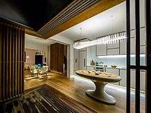
Tivoli Terrace
Tivoli Terrace, Tivoli Terrace is a contemporary refurbishment of a classic terrace house from 1880. Designed by Chris Bosse of LAVA architects the modern residence has been featured worldwide and is a showcase for a creative approach to the challenge of a small and narrow classic terrace house.
Heritage-listed buildings
The following buildings are heritage-listed:
- Juniper Hall, (1824–25) cnr Oxford and Ormond Streets
- Victoria Barracks (1841–48) Oxford Street
- Paddington Town Hall (1890–91) Oxford Street
- Paddington Court House, Jersey Road
- Paddington Public School (1870 and 1892 buildings), Oxford Street
- Uniting Church and Parsonage (1877) Oxford Street
- St Matthias Church Group (1859–61) Oxford Street
- St Matthais Former Rectory (1873) 495 Oxford Street
- St Matthias Church Hall (1882) Oxford Street
- Royal Hotel (1885) Glenmore Road
- Paddington Post Office (1885)[17]
- Tabor Cottage, Jersey Road (formerly Paddington Watch House)
Places of Worship
St_Matthias_Church_Paddington-1.jpg)
Places of worship in Paddington include:
- Paddington Church of Christ, Paddington Street.
- Paddington Uniting Church, Oxford Street.
- St Francis of Assisi Catholic Church, Oxford Street.
- St Matthais Anglican Church, Oxford Street.
- St Georges Anglican Church, Five Ways.
- St Sophia's Greek Orthodox Church, Napier Street.
Education

pre-school
- KU Peter Pan Paddington Preschool, Union Street.
- KU Kira Child Care Centre, Cnr Moore Park Road and Oatley Road.
- Paddington Church of Christ Kindergarten, Paddington Street.
- Paddington Children's Centre, Paddington Uniting Church, Oxford Street.
- SDN Paddington, Heeley Street.
primary
- Glenmore Road Public School, Glenmore Road and Cambridge Street.
- Paddington Public School, Oxford Street.
- St Francis of Assisi School, Oxford Street.
- Sydney Grammar School (Edgecliff Preparatory School) Alma Street.
secondary
- Nil. Sydney Technical High School, opened in Albion Street in 1925 was relocated to Bexley in 1956.
tertiary
- UNSW Art & Design, Napier Street.
- Academy of Makeup, Victoria Street.
Community and recreation


Community Groups
- Paddington-Darlinghurst Community Working Group.
- The Paddington Society, a community action group.
- Paddington Woollahra RSL Club, 220-232 Oxford Street.
- Paddington Woollahra Youth Service (1975-1990)
Sport
- Maccabi Tennis White City, Alma Street
- Paddington Lawn Bowls Club, Quarry Road.
- The Palms Tennis Centre, Quarry Road.
- UTS Australian Football Club play home games at Trumper Park Oval.
Libraries
- Paddington Library, a sub branch of Woollahra Library, is located at 249 Oxford Street, on the ground floor of Paddington Town Hall.
Cinemas
- Chauvel Cinema, Oatley Road next to Paddington Town Hall.
- Palace Verona cinema, 17 Oxford Street.
Art galleries

Numerous private art galleries are a feature of Paddington. They include:
- Art House Gallery, 66 Mclachlan Avenue.
- Australian Galleries, 15 Roylston Street.
- Blender Gallery, 16 Elizabeth Street.
- Christopher Day Galleries, Cnr Elizabeth & Windsor Streets.
- Martin Browne Contemporary, 15 Hampton Street.
- Maunsell Wickes at Barry Stern Galleries, Glenmore Road.
- Moran Arts Foundation, Juniper Hall 250 Oxford Street.
- Roslyn Oxley 9 Gallery, 8 Soudan Lane.
- Sabbia Gallery, 120 Glenmore Road.
- Savill Galleries, 156 Hargrave Street.
- Sherman Contemporary Art Foundation, 16 Goodhope Street.
- Wagner Art Gallery, 39 Gurner Street.
Non private galleries:
- Australian Centre for Photography, 257 Oxford Street.[18]
- Galleries UNSW, COFA, corner of Oxford Street and Greens Road.[19]
- Kudos Gallery, 6 Napier Street.[19]
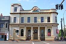
Hotels
Lord_Dudley_Hotel_Paddington.jpg)
Paddington has a notoriously high number of hotels (only a few offer accommodation)
- Arts Hotel, 21 Oxford Street.
- Bellevue Hotel, 159 Hargrave Street.
- Captain Cook Hotel, 162 Flinders Street.
- Four in Hand Hotel, 105 Sutherland street.
- Grand National, 161 Underwood Street.
- Imperial Hotel, 252 Oxford Street.
- London Hotel, 85 Underwood Street.
- Lord Dudley, 236 Jersey Road.
- Olympic Hotel, 308 Moore Park Road.
- Paddington Arms Hotel 384 Oxford Street.
- Paddington Inn Hotel, 338 Oxford Street.
- Rose, Shamrock and Thistle, 27-30 Oxford Street.
- Royal Hotel, 237 Glenmore Road, Five Ways.
- The Light Brigade Hotel, 2A Oxford Street (Woollahra).
- The Village Inn, 9-11 Glenmore Road.
- Unicorn Hotel, 106 Oxford Street.
Hospitals and aged care
Royal Hospital for Women (RHW) The Benenvolent Society of NSW officially opened the Royal Hospital for Women in Glenmore Road on 3 May 1905. The hospital remained at the site for almost 100 years, providing health care for thousands of women and their babies. In 1997 the hospital moved to Randwick, and the Paddington site was sold and developed for housing, known as Paddington Green.[5]
Scottish Hospital The Scottish Hospital in Cooper Street includes the gardens and original house 'The Terraces', one of the ten Gentry Villa subdivisions granted by Governor Bourke in the 1830s.[20] In 2010 Presbyterian Aged Care NSW & ACT (PAC) advanced plans for the rejuvenation and expansion of aged care services available from the Scottish Hospital Site, Paddington.[21]
Housing

Pre-1945
The 'Victorian' suburb of Paddington grew into its present form largely during a 30-year boom that began in the mid-1870s, particularly with developments in public transport, initially with horse-drawn buses which travelled to the city and back from a terminus at Glenmore Road, and then with the introduction of steam trams, going through to Bondi in 1884.[5]
While the suburb's growth slowed during the economic depression of the 1890s, it was completed within the first decade of the twentieth century. Also during the first half of the twentieth century, and reflecting a concern with healthy urban living, terraced housing in Australia fell into disfavour, and the inner-city areas came to be considered 'slums'. Paddington, a mainly working-class area, was affected by this change in attitude.[5]
1945-2000
After World War II, while Paddington still remained home to the many working-class families who had lived there for generations, it also became home to migrant workers and their families, who were used to living in close proximity with their neighbours. These residents were joined from the early 1960s by artists and students, attracted by the cheap rents.[5]
Gentrification also began in that decade, speeding up in the following years. With it came an interest in the unique historical and aesthetic qualities of the area, and an awareness that the suburb needed to be protected.[5]
Demographics
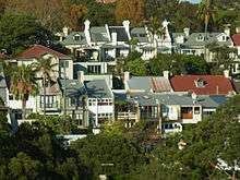
The population of Paddington, at the 2011 census, was 12,134. The area had an above average level of foreign ancestry, with only 43% of people in the 2011 census identifying that their parents were born in Australia. 62% of people in the suburb live in semi-detached, row or terrace houses or townhouse (many typical Victorian terrace houses) and 31% lived in apartments. The suburb is a high-wealth area, with a medium weekly household income of $2,290 compared to the Australian average of $1,234.[1]
Notable residents
- Phillip Adams, Broadcaster
- Hugh Connell, politician
- Andrew Andersons, architect
- David Boyd, artist
- Chris Bosse, architect
- Ita Buttrose, journalist and TV personality
- Noel Ferrier, actor
- Marea Gazzard, sculptor and ceramicist
- Peggy Glanville-Hicks, composer
- Alan Kippax, test cricketer
- Jeanie Little, TV personality
- Gordon Parsons, singer, songwriter
- Margaret Olley, artist
- Victor Trumper, test cricketer
- Jacki Weaver, actor
- David Warner, Cricketer
Further reading
- Max Kelly, Paddock full of houses: Paddington 1840-1890. Sydney: Doak Press, 1978
- Paddington. Its History, Trade and Industries 1860-1910. Published by Paddington Municipal Council, 1910. Second publishing by Salux Pty Ltd,1980. (ISBN 0959454411).
- Andrew Starr & Janet Morice. Paddington Stories. Published by Andrew Starr & Associates. Australia, 2000. (ISBN 0646404032).
Gallery
 St Sophia's Greek Orthodox Church
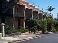 A Paddington terrace marching downhill
 Castle terrace
 Corner restaurant on Hargrave Street
 Captain Cook Hotel, Flinders Street
Paddington_Uniting_Church-1.jpg) Paddington Uniting Church
Paddington Uniting Church Victoria Barracks Gate
 War Memorial, Oxford Street
_paddington_court1.JPG) Paddington Police Station
Paddington Police Station Shop and dwelling in Italianate style, Windsor Street
External links
- Army Museum of New South Wales
- Australian Centre for Photography
- COFA, College of Fine Arts, UNSW
- Paddington Markets
- Paddo RSL
- The Paddington Society
- Urban Walkabout Guide for Paddington
- William Street
- Murder Society
References
| Wikimedia Commons has media related to Paddington, New South Wales. |
- 1 2 Australian Bureau of Statistics (31 October 2012). "Paddington (State Suburb)". 2011 Census QuickStats. Retrieved 9 January 2015.
- ↑ Gregory's Street Directory, Gregory's Publishing Company, 2007
- ↑ Barani, City of Sydney (2005). Aboriginal People and Place
- ↑ Andrew Starr & Janet Morice, Paddington Stories Published by Andrew Starr & Associates. Australia, 2000 ISBN 0-646-40403-2
- 1 2 3 4 5 6 7 8 Garry Wotherspoon (2012). "Paddington". Dictionary of Sydney. Dictionary of Sydney Trust. Retrieved 1 March 2014.
- ↑ Kelly, Max. Paddock full of houses: Paddington 1840-1890. Sydney: Doak Press, 1978
- 1 2 3 4 Andrew Starr & Janet Morice, Paddington Stories Published by Andrew Starr & Associates. Australia, 2000 ISBN 0-646-40403-2
- ↑ Sydney City Council Archives
- 1 2 Don Gazzard http://www.dongazzard.com/publications/articles/heritage-in-action.aspx
- ↑ Paddington Society Website http://www.paddingtonsociety.org.au
- ↑ Weinberger, Eric (14 January 1996). "Where Sydney Turns Victorian". The New York Times. Retrieved 6 August 2016.
- ↑ Paddington Coronation Proposal: A Town Hall Clock, The Sydney Morning Herald, (Wednesday, 16 July 1902), p.5. Paddington Town Hall: Clock for the Tower, The Sydney Morning Herald, (Saturday, 6 May 1905), p.9.
- ↑ Town Clock at Paddington, The Sydney Morning Herald, (Thursday, 31 August 1905), p.3.
- ↑ Army Museum of New South Wales, Victoria Barracks, Paddington. http://www.armymuseumnsw.com.au
- ↑ http://www.juniperhall.com.au,
- ↑ http://www.austadiums.com/stadiums/stadiums.php?id=147
- ↑ State Government Heritage Site
- ↑ The Australian Centre for Photography is supported by the Visual Arts and Craft Society
- 1 2 A gallery of the College of Fine Arts (COFA)
- ↑ The Paddington Society Website
- ↑ Presbyterian Aged Care Paddington website
Coordinates: 33°53′05″S 151°13′34″E / 33.88477°S 151.22621°E