Oyapock River Bridge
| Oyapock River Bridge | |
|---|---|
 | |
| Coordinates | 3°51′25″N 51°49′32″W / 3.85694°N 51.82556°WCoordinates: 3°51′25″N 51°49′32″W / 3.85694°N 51.82556°W |
| Carries | 2-lane wide highway |
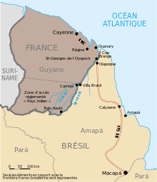
| Crosses | Oyapock River |
| Locale | Border between France (French Guiana) and Brazil |
| Official name |
French: Pont sur l'Oyapock Portuguese: Ponte sobre o Rio Oiapoque |
 The bridge on the Cayenne-Macapá route | |
The Oyapock River Bridge is a cable-stayed bridge spanning the Oyapock River to link the cities of Oiapoque in Brazil and Saint-Georges-de-l'Oyapock in French Guiana. Its construction was completed in August 2011. However, due to delays in the construction of Brazilian customs facilities, the bridge has not yet opened to traffic as of 2015.[1]
The bridge is cable-stayed, with two towers rising to 83 metres (272 ft) high, a length of 378 metres (1,240 ft) and two lanes of 3.50 metres (11.5 ft) wide. The vertical clearance under the bridge is 15 metres (49 ft).[2]
The bridge is toll-free and is accessible to both vehicles and pedestrians. On the French side there is a border checkpoint (FCP) with three government controls: the border police, the customs and the Directorate for Food, Agriculture and Forestry (French article).
History
Though the bridge was officially announced in 1997,[3] it was only after nearly 10 years of stalling and talks that a model of the bridge between France and Brazil was finally unveiled by French president Nicolas Sarkozy and Brazilian president Luiz Inácio Lula da Silva on February 14, 2008.
The site chosen for the positioning of the bridge required a length of 378 metres (1,240 ft), which includes a span of approximately 200 metres (660 ft) over water, and valued at R$62,100,000 (approximately US$50,000,000).
Construction of the bridge was undertaken by a partnership between EGESA and the Consórcio Metropolitano de Transportes - CMT, both of which are headquartered in Brasília. The Professor Carlos Augusto Bittencourt Foundation - FUNCAB (based in the city of Niterói, Rio de Janeiro) was hired to oversee the environmental engineering of the project, so that the construction of the bridge does not harm the natural environment. The bridge is part of the Guianese Shield Hub of the Initiative for the Integration of the Regional Infrastructure of South America.[4] The construction of this bridge came after the signing of an international treaty between France and Brazil in July 2005. Furthermore, the connection between Route N2 and BR-156 is yet another initiative undertaken under the scope of the Brazilian government's PAC (Growth Acceleration Plan) infrastructure project.
The Route BR-156 was conceived as development factor and a national security initiative. In the words of Walter do Carmo pioneer, entrepreneur and engineer actively involved on the project, "the federal highway BR-156 was planned to establish the terrestrial junction between the Amazon River Basin, south of Macapá and Oyapock River Basin in northern Brazil's border with French Guyana."
This bridge is the first land crossing (ferries have been used historically) along the border between France and Brazil, and indeed it is the first terrestrial crossing between French Guiana and of its neighbors in northern South America. Currently, there is a good ferry that crosses the Maroni River between French Guyana and Suriname that links Albina, in Suriname, with Saint-Laurent-du-Maroni in French Guyana. It is also possible to travel from Albina to Georgetown (Guyana) by highway; it is planned to build a bridge between Suriname and Guyana,[5] replacing the current ferry. Onwards to Venezuela, one can only travel by sea, but a road link is planned.[6] In this case, it will be possible to drive from Macapá to Venezuela and Colombia with only one ferry crossing.
Though the Oyapock Bridge was to be inaugurated in early 2012,[7] it is to remain closed until the road on the Brazilian side is completely paved. As of April 2013, the opening was scheduled for the end of 2013, but as of January 2015 the bridge had not opened due to delays in the construction of the Brazilian customs facility, and no opening date was forecast.[1] If the highway is opened to traffic, it will be possible to drive on uninterrupted, paved roadways from Cayenne to Macapá, the capital of the Brazilian state of Amapá.
Gallery
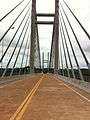 View from the French side
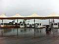 Control posts
See also
- Approuague Bridge — another bridge on the N2 road, spanning the Approuague River near Régina
- Takutu River Bridge — a similar bridge between Brazil and Guyana.
References
- 1 2 "Brasil 'abandona' ponte construída em parceria com a França" [Brazil 'abandons' bridge built in partnership with France]. Folha de S. Paulo (in Portuguese). 2015-02-25. Retrieved 2015-03-17.
- ↑ http://www.guyane.developpement-durable.gouv.fr/rubrique.php3?id_rubrique=233
- ↑ Neuman, William (7 December 2015). "Linking Brazil to French Guiana, a Bridge for No One". The New York Times. The New York Times Company. Retrieved 4 January 2016.
- ↑ IIRSA.org - Guyana Shield Hub presentation
- ↑ http://rjrnewsonline.com/news/regional/guyanasuriname-bridge
- ↑ GNNL. "Site layout and property design". Guyana Chronicle.
- ↑ Editorial Staff. "Informe MRE. Comunidades Brasileiras no Exterior". www.jornal.us.
External links
- France 24 - A bridge between Europe and Latin America
- Gouvernement Francais Bridge on Oct. 20, 2011