Oughtibridge
| Oughtibridge | |
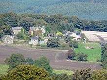
 The River Don flows under the road bridge at Oughtibridge with the Cock Inn pub in the background |
|
 Oughtibridge |
|
| Population | 3,542 |
|---|---|
| OS grid reference | SK3093 |
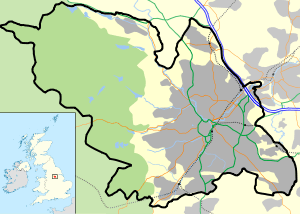
| Civil parish | Bradfield |
| Metropolitan borough | Sheffield |
| Metropolitan county | South Yorkshire |
| Region | Yorkshire and the Humber |
| Country | England |
| Sovereign state | United Kingdom |
| Post town | SHEFFIELD |
| Postcode district | S35 |
| Dialling code | 0114 |
| Police | South Yorkshire |
| Fire | South Yorkshire |
| Ambulance | Yorkshire |
| EU Parliament | Yorkshire and the Humber |
| UK Parliament | Penistone and Stocksbridge |
Coordinates: 53°26′10″N 1°32′20″W / 53.436°N 1.539°W
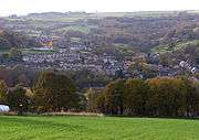
Oughtibridge (/ˈuːtᵻbrɪdʒ/ OOT-i-brij) is a residential village on the northern outskirts of Sheffield within the bounds of Bradfield civil parish. The village stands 5 miles (8 km) northwest of the city centre in the valley of the River Don. The population of the village has increased significantly in recent years due to much private housing development and stood at 3,542 in 2006 over an area of 355 hectares (880 acres).[1] The population of Oughtibridge increased to 3,584 in 2011.[2]
History
Origins
The origins of Oughtibridge date back to the first part of the 12th century when a ford existed in the area over the Don. The ford was managed by a man named Oughtred who resided in a nearby cottage. When a bridge was built on the spot in approximately 1150 it became known as Oughtred’s Bridge or by his nickname of Oughty’s Bridge and the small settlement around the bridge adapted the same name. The hamlet of Oughtibridge grew up as a focal point for local farming communities and the first documented mention of Oughtibridge occurred in 1161 when one of the signatories of an agreement on the grazing rights of Ecclesfield Priory was “Ralph, the son of Oughtred”. The name Ughtinabrigg, meaning Oughtred’s Bridge in Middle English, was used in the document. The priory’s grazing rights included Beeley Wood, a remnant of which still exists to the east of the village. Oughtibridge Hall was built on the high ground to the east of the hamlet in the 16th century; it still stands today and is a Grade-II-listed building.
Onesacre
The little hamlet of Onesacre, approximately half a mile west of Oughtibridge, was mentioned in the Domesday Book of August 1086.[3] However, its history goes back to Anglo-Saxon times when it was part of the estate of the Saxon lord Godric. The Onesacre estate, then known as Anesacre, was owned by the Le Rous family after the Norman Conquest until around 1380 when it passed to the Stead family who were large land-owners in the Sheffield and Hallamshire area. The present buildings date from the middle of the 17th century and Onesacre Hall is Grade II* listed.[4]
Industrial development
Oughtibridge remained a small isolated rural hamlet over the centuries and even by 1747 it was made up of only five families. However, the population started to rise in the latter part of the 18th century as a result of the Industrial Revolution and a further expansion in farming. Oughtibridge's position within the Don valley made it a prime location as the water power of the river could be used to drive the machinery of the early and mid-19th century.
In 1841 the population had risen to 1,005 with Oughtibridge forge being the main industry in the village. The forge still stands today on Forge Lane and is a Grade-II-listed building; it has been renovated in recent years and turned into several apartments within a new housing development. There was a corn mill, paper mill, tannery and a small brewery among the other industries at this time. During the second half of the 19th century Oughtibridge reached its height as an industrial centre with the opening of Oughty Bridge railway station in 1845 on the Sheffield, Ashton-under-Lyne and Manchester Railway. By 1891 the population had grown to 1,784.
The Dixon family bought the paper mill to the northwest of the village in 1871 and it became a flourishing business, being one of the first to use wood pulp to produce paper instead of rags. The mill specialised in tissues, making the Dixcel brand for many years. Wood pulp for Dixon's paper mill was imported from the Toppila pulp mill (Toppila Oy) in Oulu, Finland from 1931–1985.[5][6] The Dixons signed an agreement with the railway company to provide a siding for the works to transport raw materials and the finished product. The paper mill was closed in 2007 leaving only converting lines operational. Before this there were converting and two paper machines, the site having several owners after the Dixons, namely British Tissues, Jamont UK and Fort James, and is now part of the Georgia-Pacific group. The paper machines are currently mothballed.
Another company to use the railway was the Oughtibridge Silica Firebrick Company, which had a factory by the railway line near the station; the works were taken over by the Steetley company in 1947.[7][8] The Steetley refractory works on Station Lane closed in the 1980s with half the site being redeveloped for housing while the remaining half was taken over by Intermet Refractory Products Ltd.
Present day
The modern-day development of Oughtibridge has seen it become a commuter village with many of the residents working in nearby Sheffield and much of the local industry having given way to private housing development. There are approximately 1,355 housing units in Oughtibridge, 79% of which are owner occupied; there is a significantly lower percentage of rented properties compared to the rest of Sheffield.[9]
The A6102 road, one of the main transport exits from the northwest of Sheffield towards Stocksbridge and eventually Manchester, goes through Oughtibridge splitting into a one way system in its passage through the village. There are good public transport links to Sheffield by bus including a link to the Sheffield Supertram network at Middlewood. There are four public houses within Oughtibridge (The Pheasant, The Cock Inn, The Travellers, and The Hare and Hounds). There used to be five: The White Hart is now a bridal shop. Oughtibridge primary school is situated on Naylor Road; secondary school pupils have to travel to Bradfield School in the nearby village of Worrall.
The Parish Church of the Ascension on Church Street was built in 1842. It has a two manual organ by Nelson - unusually the great organ has tracker action but the swell pneumatic. It underwent cleaning and partial reconstruction in 2012. The great has a fine if not loud open diapason. Originally part of the Wadsley parish, Oughtibridge is now a separate parish although the vicar of Wadsley still appoints the vicar at Oughtibridge. Coronation Park is situated in the centre of the village by the river and includes a children's playground and tennis courts as well as some fine specimens of trees. Sheffield Canoe Club use the river by the park as their outdoor base.[10] Just across the road from the park is the hall of the Oughtibridge Brass Band who were formed around 1890. The War Memorial sports ground is situated next to the River Don slightly downstream, providing facilities for the village football and cricket teams. The ground was donated by the Silica Firebrick Company in 1921.
|


References
- ↑ Sheffield City Council Neighbourhood Profiles. Gives population and area data plus other information.
- ↑ Oughtibridge is made up of 12 Output Areas in the Stocksbridge and Upper Don ward http://ukcensusdata.com/stocksbridge-and-upper-don-e05001063#sthash.dbtoV5GV.iyRRK3aN.dpbs
- ↑ Domesday Book Index. Shows Onesacre listed in Domesday Book.
- ↑ Eric Youle‘s Sheffield history material. Gives historical details of Onesacre.
- ↑ Kainua, Lauri (1981). Osakeyhtiö Toppila - Toppila Oy (Toppila Ltd.) 1927–1974 (in Finnish). Oulu: Toppila Oy (Toppila Ltd.).
- ↑ Eräpuu, Eero (1956). Osakeyhtiö Toppila. (engl. Lars Palmroos). Oulu: Toppila Oy (Toppila Ltd.).
- ↑ Sanderson, Doug (1999). A Layman's Look at the History, Industry, People and Places of Oughtibridge, Worrall and Wharncliffe Side. Sheffield. p. 76.
- ↑ Competition Commission. Gives details of Steetley refractory.
- ↑ Oughtibridge Neighbourhood Profile 2006/7. Gives details of Housing.
- ↑ Sheffield Canoe Club. States that they use the Don at Oughtibridge as their outdoor base.
External links
| Wikimedia Commons has media related to Oughtibridge. |
- Onesacre in the Domesday Book
| About Sheffield | |||||||
|---|---|---|---|---|---|---|---|
| Electoral wards |
| ||||||
| Suburbs and estates |
| ||||||
| Towns and villages |
| ||||||
| Other areas | |||||||
| |||||||