Ostroh
| Ostroh Острог Ostróg | |||
|---|---|---|---|
| City | |||
|
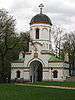
Church of the Dormition of the Virgin Mary | |||
| |||
 Ostroh | |||
| Coordinates: 50°20′0″N 26°31′0″E / 50.33333°N 26.51667°E | |||
| Country |
| ||
| Oblast |
| ||
| First mentioned | 1100 | ||
| City rights | 1795 | ||
| Government | |||
| • Mayor | Oleksandr Shyker | ||
| Area | |||
| • Total | 10.9 km2 (4.2 sq mi) | ||
| Population (2001 census) | |||
| • Total | 14,801 | ||
| • Density | 1,358/km2 (3,520/sq mi) | ||
| Time zone | EET (UTC+2) | ||
| • Summer (DST) | EEST (UTC+3) | ||
| Postal code | 35800—35807 | ||
| Area code(s) | +380 3654 | ||
| Sister cities |
| ||
| Website | http://www.ostroh.rv.ua/ | ||


Ostroh (Ukrainian: Остро́г; Russian: Остро́г, Ostrog, Polish: Ostróg) is a historic city located in Rivne Oblast (province) of western Ukraine, located on the Horyn River. Ostroh is the administrative center of the Ostroh Raion (district) and is itself designated as a special administrative subordination within the oblast. The current estimated population is around 15,202 (as of 2007). The Ostroh Academy was established here in 1576, the first higher educational institution in modern Ukraine. Furthermore, in the 16th century, the first East Slavic books, notably the Ostrog Bible, were printed there.
History

The Hypatian Codex first mentions Ostroh in 1100, as a fortress of the Volhynian princes. Since the 14th century, it was the seat of the powerful Ostrogski princely family, who developed their town into a great center of learning and commerce. Upon the family's demise in the 17th century, Ostroh passed to the family of Zasławski and then Lubomirski.
In the second half of the 14th century, Ostroh, together with the whole of Volhynia, was annexed by the Grand Duchy of Lithuania. Following the Union of Lublin (1569), the town became part of the Crown of the Kingdom of Poland, where it remained until the late 18th century (see Partitions of Poland). Ostroh, known in Polish as Ostrog, received Magdeburg rights in 1585. In the 17th century, the town was surrounded by fortifications, with a moat, a rampart and five bastions. In 1609–1753, it was the capital of the Ostrogski family fee tail, founded by Voivode Janusz Ostrogski, who invited Bernardine monks to Ostrog. Furthermore, the town had a Calvinist academy; among its lecturers was Andrzej Wegierski.
During the Khmelnytsky Uprising, the town was burned by the Cossacks, and its residents were murdered. Ostrog slowly recovered, and in the second half of the 18th century, it became the seat of a Jesuit college (see Collegium Nobilium). In 1793, the town was annexed by the Russian Empire, in which it remained until 1918. Railroad lines, built in the 19th century, missed Ostrog, and as a result, the town stagnated.
In the interbellum period, Ostrog belonged to County of Zdolbunow, Volhynian Voivodeship of the Second Polish Republic. The town was an important garrison of the Polish Army, and the Border Protection Corps (KOP). Here, the KOP Battalion “Ostrog” was stationed, as well as the 19th Volhynian Uhlan Regiment. On July 7, 1920, during the Polish-Soviet War, a battle between a Polish unit under Wincenty Krajowski, and the Bolsheviks of Semyon Budyonny’s 1st Cavalry Army took place. As in 1919 - 1939 Ostrog was located in close proximity to the Polish - Soviet border, special passes were required to enter some districts of the town.
Following the 1939 Soviet invasion of Poland, Ostrog was annexed by the Soviet Union, as part of the Ukrainian Soviet Socialist Republic. An unknown number of the town’s residents were forcibly sent to Siberia.
Landmarks include the Ostroh Castle on the Red Hill, with the Epiphany church (built in the fifteenth century) and several towers. To the north-west from the castle stand two sixteenth-century towers. The suburb of Mezhirichi contains the Trinity abbey, with a fifteenth-century cathedral and other old structures.
- Ostroh landmarks
 Entrance to the Orthodox cathedral complex.
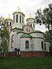 Epiphany Cathedral (ca. 1521, restored 1887-91)
 Tatar Gate Tower (ca. 1500)
 Lutsk Gate Tower (ca. 1500)
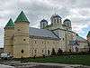 Trinity Church of Mezhyrich Monastery (15th century)
See also
- Ostrogski family
- Ivan Fyodorov (printer)
- Ostroh Castle
- Ostroh Academy
- National University Ostroh Academy
References
- ↑ "Sister cities". Official website of the Ostroh City Council (in Ukrainian). Retrieved 2008-06-14.
External links
| Wikimedia Commons has media related to Ostroh. |
- "Main". Official website of the Ostroh City Council (in Ukrainian). Retrieved 2008-06-14.
- "Ostroh". art.lutsk.ua (in Ukrainian). Retrieved 2008-06-14.
- "Ostroh free classifieds newspaper". Ostroh free classifieds newspaper (in Ukrainian). Retrieved 2013-01-22.
| Raions | |||||||
|---|---|---|---|---|---|---|---|
| Cities |
| ||||||
| |||||||
Coordinates: 50°20′N 26°31′E / 50.333°N 26.517°E