Osasco
| Osasco | |||
|---|---|---|---|
| Municipality | |||
|
Downtown Osasco | |||
| |||
 Location in São Paulo state | |||
 Osasco Location in Brazil | |||
| Coordinates: 23°31′58″S 46°47′58″W / 23.53278°S 46.79944°WCoordinates: 23°31′58″S 46°47′58″W / 23.53278°S 46.79944°W | |||
| Country |
| ||
| Region | Southeast Region | ||
| State | São Paulo | ||
| Metrop. region | Metropolitan Region of São Paulo | ||
| Government | |||
| • Mayor | Antonio Jorge Pereira Lapas (PT) | ||
| Area[1] | |||
| • Total | 64.95 km2 (25.08 sq mi) | ||
| Elevation | 760 m (2,490 ft) | ||
| Population (2015)[1] | |||
| • Total | 691,652 | ||
| • Density | 11,000/km2 (28,000/sq mi) | ||
| Time zone | BRT/BRST (UTC-3/-2) | ||
| Postal code | 06000-000 | ||
| Area code | +55 11 | ||
| Website |
www | ||


Osasco (Portuguese pronunciation: [oˈzasku]) is a municipality in São Paulo State, Brazil, is located in the Greater São Paulo[2] and ranking 5th in population among São Paulo municipalities. According to the IBGE 2015, Osasco currently has the 9th highest Gross Domestic Product in Brazil, and the 2nd largest in the State of São Paulo The population is 696,382 (2016 est.) in an area of 64.95 km².[1] It is among the world's more dense cities, similar in density to Tokyo and New York City. It's considered the major urban centre of the Western portion of the Greater São Paulo. It used to be a district of São Paulo City until February 19, 1962, when Osasco became a municipality of its own.[3] The city motto, is "Urbs labor", Latin phrase that means "City work".
History
Pre-Columbian era
The region that is now Osasco was inhabited by indigenous Tupi-Guaraní people.
Colonial Brazil
Bandeirantes lived in the region that is now Osasco, then called "Vila de Quitaúna". The famous "bandeirante" António Raposo Tavares lived there.
Early modern period
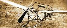
Osasco was founded, in the 19th century, by the Italian immigrant Antônio Giuseppe Agù (currently the name of one of the main streets in Osasco). He came from the commune Osasco in the province of Turin.To Help of the Baron Dimitri Sensaud de Lavaud. Osasco is said to be the place of the first heavier-than-air flight in Latin America. Immigrants from Italy, Spain, Portugal, Germany, Ireland, Armenia (Trade), Lebanon (Trade), Israel (Trade) and Japan (Rural) came to Osasco in the period.
Independence
Osasco became autonomous from the city of São Paulo on February 19, 1962.[3]
Some widely known events after the autonomy
- Strike of the Cobrasma factory (1968)
- Explosion of the Osasco Plaza Shopping (1996).
- The first Latin American flight was in Osasco, in 1910, by Dimitri Sensaud de Lavaud[4]
Economy
Osasco was an industrial city, but there was industrial decentralization to other regions and today the city is moving toward the shopping and services. Osasco is headquarters of Bradesco the third largest bank in Brazil. Currently there are large companies with a presence as Natura, Coca-Cola, Carrefour, Wal-Mart, Colgate-Palmolive and many others. Osasco is the ninth richest city in the country. GDP of Osasco: R$ 55.515.707[5]
Main Companies
- ABB Group
- Adamas
- ArvinMeritor
- Associação Comercial e Empresarial de Osasco (ACEO)
- Avon
- Bradesco
- Carrefour
- Chevron
- Coca-Cola
- Colgate-Palmolive
- Danfoss do Brasil
- Ebicen
- Group Extrema
- Hot Stock
- Intermarine
- Makro
- Metrópoles home e club
- Natura
- Nova Osasco Esquadrias
- Osram
- Pão de Açúcar
- Pedágio Sem Parar
- Rede TV
- Rockwell International
- Sam's Club
- SBT
- Unibanco – CPD
- Wal-Mart
Market city
- Market city of Osasco
Shopping Malls
- Shopping União de Osasco
- Osasco Plaza Shopping
- Super Shopping Osasco
- Shopping Galeria
- Fantasy Shopping
Banks
Sport
Sports clubs
- Finasa Volleyball
- Grêmio Esportivo Osasco Football
- Sollys/Osasco
- Associação Cristã de Moços/ACM
- SESI Jardim Piratininga
- Clube Floresta
- Clube dos Subtenentes e Sargentos do II Exército
Sports competitions
- Racing of Saint Antônio
- University games
- Racing and walk – Marketing Sports
- Osasco went prime city make Circuito Running for Nature, racing and walk (SportsFuse).
Geography
Is an average elevation of 792 meters and 65 km² of area. [6] Its boundaries are São Paulo to the north, east and south, Cotia to the southwest, Carapicuíba and Barueri to the west and Santana de Parnaíba to the northwest.
Climate
As in almost all the metropolitan area of São Paulo, the climate is subtropical, specifically humid subtropical. Little hot summer and rainy mild winter and categories. The average annual temperature is around 18 °C, being the month of July the coldest (average 12 °C) and warmest February (average 30 °C). The annual rainfall is around 1400 mm.[7]
| Climate data for Osasco (1962–1990) | |||||||||||||
|---|---|---|---|---|---|---|---|---|---|---|---|---|---|
| Month | Jan | Feb | Mar | Apr | May | Jun | Jul | Aug | Sep | Oct | Nov | Dec | Year |
| Record high °C (°F) | 34.2 (93.6) |
34.6 (94.3) |
33.6 (92.5) |
31.3 (88.3) |
29.8 (85.6) |
28.9 (84) |
29.3 (84.7) |
33 (91) |
37.4 (99.3) |
34.4 (93.9) |
35.2 (95.4) |
35.7 (96.3) |
37.4 (99.3) |
| Average high °C (°F) | 27.4 (81.3) |
28 (82) |
27.3 (81.1) |
25.1 (77.2) |
23 (73) |
21.7 (71.1) |
21.8 (71.2) |
23.3 (73.9) |
23.9 (75) |
24.7 (76.5) |
25.9 (78.6) |
26.3 (79.3) |
24.5 (76.1) |
| Daily mean °C (°F) | 22.2 (72) |
22.4 (72.3) |
21.7 (71.1) |
19.8 (67.6) |
17.6 (63.7) |
16.4 (61.5) |
15.8 (60.4) |
17.1 (62.8) |
17.8 (64) |
19 (66) |
20.3 (68.5) |
21.2 (70.2) |
18.5 (65.3) |
| Average low °C (°F) | 18.7 (65.7) |
18.8 (65.8) |
18.2 (64.8) |
16.3 (61.3) |
13.9 (57) |
12.3 (54.1) |
11.7 (53.1) |
12.8 (55) |
13.9 (57) |
15.3 (59.5) |
16.5 (61.7) |
17.8 (64) |
14.5 (58.1) |
| Record low °C (°F) | 10.2 (50.4) |
11.2 (52.2) |
10.9 (51.6) |
6 (43) |
5.2 (41.4) |
0.9 (33.6) |
0.2 (32.4) |
−2.2 (28) |
2.1 (35.8) |
4.2 (39.6) |
6.9 (44.4) |
7.3 (45.1) |
−2.2 (28) |
| Average precipitation cm (inches) | 24 (9.4) |
25 (9.8) |
16 (6.3) |
8 (3.1) |
7 (2.8) |
6 (2.4) |
4 (1.6) |
3 (1.2) |
7 (2.8) |
13 (5.1) |
14 (5.5) |
19 (7.5) |
146 (57.5) |
| Source: INMET – Clima[8] | |||||||||||||
Geopolitics
Osasco ranks 5th among São Paulo municipalities by population, with 666,740 residents as of 2010. The city also plays an important role in the state's industry, education and media, hosting prominent schools, universities and TV stations.
Demography
- Total: 652.593 inhabitants, 2000.
- Urban: 652.593
- Rural: 0
- Demographic density (hab./km²): 10,055
- Child mortality until 1 year (in 1000): 15.62
- Life expectancy (years): 71.35
- Fertility (children per women): 1.94
- Literacy: 94.24%
- HDI : 0.818
- HDI-M Income: 0.769
- HDI-M Longevity: 0.772
- HDI-M Education: 0.913
(Source: IPEA data)
Changing demographics of the city of Osasco
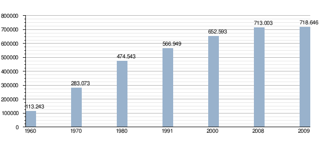
Source: IBAM
Ethnicity
| Ethnic groups | Percent |
|---|---|
| White | 66.3% |
| Black | 4.5% |
| Pardo (Brown) | 27.5% |
| Asian | 0.8% |
| Amerindian | 0.2% |
Source: IBGE
Religion
| Religion | Percentage | Number |
| Catholic | 64.75% | 422.553 |
| Protestant | 20.54% | 134.042 |
| No religion | 9.33% | 60.886 |
| Kardecist | 0.90% | 5.873 |
| Buddhist | 0.23% | 1.500 |
| Jewish | 0.04% | 261 |
Source: IBGE 2000
Hidrography
- Baronesa Stream
- Bussocaba Stream
- Divisa Stream
- Continental Stream
- Areia Stream
- Chico Mendes Lake
- Três Montanhas Lake
- João Alves Ribeira
- Red Ribeira
- Tietê River
Main Neighbourhoods
- Adalgisa
- Aliança
- Ayrosa
- Baronesa
- Bela Vista
- Bonança
- Bonfim
- Bussocaba City
- Castelo Branco
- Centro
- Cidade das Flores
- Cidade de Deus
- Cipava
- Cipava II
- City Bussocaba
- Conceição
- Conjunto Metalúrgicos
- Continental
- Distrito Industrial Altino
- Distrito Industrial Anhanguera
- Distrito Industrial Autonomistas
- Distrito Industrial Centro
- Distrito Industrial Mazzei
- Distrito Industrial Remédios
- Helena Maria
- IAPI
- Jaguaribe
- Jardim Açucará
- Jardim Agua Boa
- Jardim das Bandeiras
- Jardim D'Abril
- Jardim D'Avila
- Jardim das Flores
- Jardim Elvira
- Jardim Guadalupe
- Jardim Iguaçu
- Jardim Ipê
- Jardim Joelma
- Jardim Mutinga
- Jardim Oriental
- Jardim Piratininga
- Jardim Platina
- Jardim Roberto
- Jardim Veloso
- Jardim São Victor
- km 18
- Munhoz Júnior
- Novo Osasco
- Padroeira II
- Paiva Ramos
- Parque Cachoeirinha
- Parque Palmares
- Pestana
- Portal D'Oeste
- Presidente Altino
- Quitaúna
- Raposo Tavares
- Remédios
- Recanto das Rosas
- Rochdale
- Santa Fé
- Santa Maria
- Santo Antônio
- São Pedro
- Setor Militar
- Três Montanhas
- Umuarama
- Vila Campesina
- Vila Menck
- Vila Militar
- Vila Osasco
- Vila São José
- Vila Yara
- Vila Yolanda
Transportation

Osasco due to its proximity to São Paulo, has a transit similar to the state capital, that is one of the more you carry the world. In the city can be found means of road and rail.
Main Streets


- Avenida dos Autonomistas
- Viaduto Reinaldo de Oliveira
- Avenida Maria Campos
- Avenida Bussocaba/Avenida Prefeito Hirant Sanazar
- Viaduto Presidente Tancredo Neves
- Avenida Presidente Médici
- Avenida Getúlio Vargas
- Avenida Visconde de Nova Granada/Avenida Sport Club Corinthians Paulista
- Avenida Santo Antônio
- Avenida Antônio Carlos Costa
- Rua da Estação
- Avenida Pedro Pinho
- Avenida João de Andrade
- Avenida Sarah Veloso
- Complexo Viário Fuad Auada
- Avenida Hilário Pereira de Souza
- Avenida Franz Voegelli
- Avenida Benedito Alves Turíbio
- Avenida Giuseppe Sacco
- Avenida Padre Vicente Mellilo/Avenida Prestes Maia
- Avenida Novo Osasco
Train
It is linked by CPTM rapid transit to São Paulo by the 8 and 9 [9] train lines.
Roads
Roads of Osasco:
- Rodovia Castelo Branco (SP-280),
- Rodovia Anhangüera (SP-330),
- Rodoanel Mário Covas (SP-21) and
- Rodovia Raposo Tavares (SP-270).
Airports of São Paulo

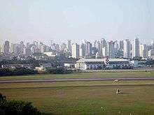

São Paulo has two main airports:
- The São Paulo-Guarulhos International Airport (IATA: GRU) for the international flights
- The Congonhas-São Paulo Airport (IATA: CGH) for domestic and regional flights. Another airport, the Campo de Marte Airport, serves light aircraft and helicopters.
Companies of bus
- Viação Osasco
- Auto Viação Urubupungá
Bus station
- Terminus Amador Aguiar (Vila Yara)
- Terminus Largo de Osasco
- Bus station of Osasco
Media
Newspaper
- Diário da Região;
- Visão Oeste;
- Página Zero;
- Correio Paulista;
- Jornal do Trem;
Newsweb
- Portal PlanetaOsasco.com;[10]
- Webdiário;
Radio
- Nova Difusora 1540 AM e;
- Rádio Iguatemi AM.
- Radio Terra FM.
- Osascoradioweb
Channel

- Sistema Brasileiro de Televisão (SBT), channel 04 VHF (São Paulo);
- Nova Geração de Televisão (NGT), channel 48 UHF;
- TV Shop Tour channel 46 UHF;
- TV Osasco, channel 22 UHF;
- Net Serviços de Comunicação e;
- RedeTV, channel 09 VHF (São Paulo).
Government
Executive
- Mayors of Osasco
- Hirant Sanazar (1962–1967)
- Guaçu Piteri (1967–1970)
- José Liberatti (1970–1973)
- Francisco Rossi (1º Mandate: 1973–1977)
- Guaçu Piteri (1977–1982)
- Humberto Parro (1983–1988)
- Francisco Rossi (2º Mandate: 1989–1992)
- Celso Giglio (1º Mandate: 1993–1996)
- Silas Bortolosso (1997–2000)
- Celso Giglio (2º Mandate: 2001–2004)
- Emidio Pereira de Souza (1º Mandate: 2005-2008)
- Emidio Pereira de Souza (2º Mandate: 2009-2012)
- Antônio Jorge Pereira Lapas (2013-Today)
Educational
Colleges and universities
- Serviço Nacional de Aprendizagem Industrial (Escola Senai Nadir Dias de Figueredo)CFP 1.19
- Serviço Nacional de Aprendizagem Comercial (SENAC)
- Faculdade de Ciências da Fundação Instituto Tecnológico de Osasco (Fac-FITO)[11]
- Fundação Instituto Tecnológico de Osasco (FITO)[12]
- Faculdade Integração Zona Oeste (Fizo)- Anhanguera
- Centro Universitário FIEO – UNIFIEO[13]
- Faculdade Fernão Dias
- Faculdade FIPEN
- São Paulo State Technological College ( FATEC )
- Universidade Federal de São Paulo
Culture
Libraries
- Biblioteca Municipal Monteiro Lobato
- Biblioteca Heitor Sinegalia
- Biblioteca Manoel Fiorita
- Library of Centro Universitário FIEO
- Library of Faculdade de Ciências da FITO
Theatres
- Teatro Municipal de Osasco
- Espaço Grande Otello
- Teatro do Sesi
Spaces of culture
- Centro de Eventos Pedro Bortolosso
Museums
- Museu Dimitri Sensaud de Lavaud
Schools of education in culture
- Escola de Artes César Antonio Salvi
House of events the culture
- Casa de Angola
- Casa do Violeiro do Brasil
Leisure and natural environment
- Parque Ecológico Nelson Vilha Dias
- Parque Municipal Dionísio Alvares Mateos
- Parque Municipal Chico Mendes
- Parque Clóvis Assaf
- Park of Lazer Antônio Temporim
- Parque Ecológico Jardim Piratininga
Health
Hospitals:
- AACD Associação de Assistência à Criança Deficiente
- Hospital Cruzeiro do Sul
- Hospital e Maternidade Amador Aguiar
- Hospital e Maternidade João Paulo II
- Hospital Montreal S/A
- Hospital Municipal Antônio Gíglio
- Hospital Dr. Vivaldo Martins Simões ( Regional )
- Hospital e Maternidade Sino Brasileiro
Notable Osasquenses

- Adriana Nascimento, actress
- André Lima Pedro, football player
- Antonio Agù, founder
- Bruno Caboclo, basketball player
- Cristiane Rozeira de Souza Silva, football player
- Cristiano Lima da Silva, football player
- Eduardo Marques de Jesus Passos, football player
- Eduardo Rodrigues, TV Encyclopedia/Gentleman/Squared Gol preparator
- Fábio de Toledo Pereira, notable Computer Scientist
- Guitom Santa Cruz, musician
- Hirant Sanazar, politician
- Igor Nascimento Soares, football player
- Jair da Costa, football player
- José Bonifácio de Oliveira Sobrinho, businessman
- Júlio Santos, football player
- Júlio Terceiro, football player
- Kléber Giacomance de Souza Freitas, football player
- Manoel Leão, journalist
- Marcos Willians Herbas Camacho, drug trafficker
- Paulinho Kobayashi, football player
- Silas Bortolosso, politician
- Silvio Pereira, sociologist
- Sônia Lima, actress
- Vágner Benazzi, football player
- Vítor Maldonado Lionize, legendary prosecutor
- Zezeh Barbosa, actress
- Natalia Nascimento, Youth Ambassador
Sister cities
Bibliography
- SANAZAR, Hirant. Osasco – Sua história, sua gente: Osasco, ed. do author, 2003.
- FAVARÃO, Mazé (apres.). Osasco conta sua história através dos bairros: Osasco, Secretaria de Educação, 2007.
- METROVICHE, Eduardo (org.). Osasco – Um século de fotografia: Osasco, Maxprint Editora, 2007.
See also
- Microregion of Osasco
- Greater São Paulo
References
- 1 2 3 "IBGE - Instituto Brasileiro de Geografia e Estat韘tica".
- ↑ Divisão Territorial do Brasil
- 1 2 IBGE, history
- ↑ "::: Câmara Municipal de Osasco ::: Estado de São Paulo". www.camaraosasco.sp.gov.br. Retrieved 2016-11-20.
- ↑ "IBGE". ibge.gov.br.
- ↑ "IBGE". ibge.gov.br.
- ↑ Osasco – SP. tempoagora.uol.com.br
- ↑ "INMET – Climatologia – Gráficos Climatológicos".
- ↑ "CPTM lines". CPTM (Companhia Paulista de Trens Metropolitanos). Retrieved 2008-12-12.
- ↑ "Portal Planeta Osasco".
- ↑ http://www.fito.br/facfito/index.htm
- ↑ "FITO BR - Em Construção".
- ↑ "Centro Universitário FIEO".
- ↑ "International Exchange". List of Affiliation Partners within Prefectures. Council of Local Authorities for International Relations (CLAIR). Retrieved 21 November 2015.
External links
- (Portuguese) Official City Hall Site
- (Portuguese) Câmara Osasco citty
- Osasco, Brazil
- (Portuguese) Hymn of Osasco in Portuguese
 |
Santana de Parnaíba and São Paulo | | ||
| Barueri, Carapicuíba, Cotia and Santana de Parnaíba | |
São Paulo | ||
| ||||
| | ||||
| Cotia and São Paulo |