Oru East
| Oru East | |
|---|---|
| LGA | |
| Nickname(s): ORELGA | |
| Country |
|
| State | Imo State |
| Area | |
| • Total | 53 sq mi (136 km2) |
| Population (2006) | |
| • Total | 111,743 |
| Time zone | WAT (UTC+1) |
Oru-East is a Local Government Area of Imo State, Nigeria. Its headquarters is at Omuma. Njaba River provides residents of the area access to natural water.[1]:1
Prominent towns in Oru-East council area include Omuma, Awo-omamma, Akuma and Amiri.[1]
Location and Boundaries
Oru East is bounded by Njaba LGA, Mbaitoli, Orlu, Oguta, Orsu and Oru West Local Government Areas.[2] From the west of Amiri and north of Awo-omamma, Oru-East shares common border with Mgbidi and Otulu towns in Oru West. Oru-East shares border with Atta and Okwudor towns in Njaba Local Government Area via Amiri and Awo-Omamma on the eastern axis.[1]:1 Orlu shares border with Oru East at Obor Town. On the west of Awo-omamma, it shares borders Oguta LGA on the northern part of Abiaziem, Mgbele, Awa and Akabor communities.[3] The LGA also shares a border with Mbaitoli LGA via Eziama-Obiato on the south of Awo-omamma.[1]:1[2]
Oru-East has an area of 136 km² and estimated population of 111,743 (2006 census).[2] The postal code of the area is 474.[4]
Agriculture
Oru-East is a farming and fishing area within Orlu agricultural zone. Some of the cash crops produced in the area include Yam, cassava, oil palm, plantain, banana, pineapple, and maize.[1]:5[5]
Oil and Gas Exploration
As it is in neighbouring oil rich Oru West and Oguta LGAs, Oru-East has been proven rich in crude oil and gas.[6] As of 2010, production projection from Addax Petroleum, already operating in Njaba River basin under Oil Mining License, OML 124,[3][7] was placed at about 15,000 to 20,000 barrels of oil per day from Awo-omamma in the council area.[7][8]
References
- 1 2 3 4 5 Kelechi Chika Ubaku (September 2013). "The Role of Festivals in Awo-Omamma - Amiri Relations, since 1970" (PDF). iosrjournals.org. IOSR Journal Of Humanities And Social Science (IOSR-JHSS). 14 (5): 1. ISSN 2279-0837.
- 1 2 3 "Imo (State): Subdivision". www.citypopulation.de. Retrieved May 21, 2016.
- 1 2 Obasi Investment Limited, Nigeria. "Abiaziem Community in Oguta, Imo State Nigeria.". abiaziem.blogspot.co.uk. Retrieved December 2, 2015.
- ↑ "Post Offices- with map of LGA". NIPOST. Retrieved 2009-10-20.
- ↑ F.N Nnadi; et al. (2009). "Farmers' Sustained Adoption Decision Behaviors of Maize/Cassava Intercrop Technology in Imo State: Lessons for Extension Policy" (PDF). sciencepub.net. World Rural Observations. 1 (1): 2. ISSN 1944-6551.
- ↑ Vanguard, Nigeria (March 14, 2014). "Imo Govt discovers more crude oil". vanguardngr.com. Retrieved November 30, 2015.
- 1 2 Rigzone (January 28, 2009). "Addax Strikes Oil at Njaba 2 Well Onshore Nigeria". www.rigzone.com. Retrieved December 2, 2015.
- ↑ Vanguard, Nigeria (June 7, 2010). "Owerri to get oil, gas lab". vanguardngr.com. Retrieved November 30, 2015.
State capital: Owerri | ||
| LGAs | 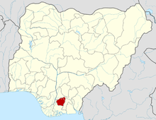 | |
External links
- "Oru East (Local Government Area) Position on the Map". Retrieved May 21, 2016.