Ortoire River
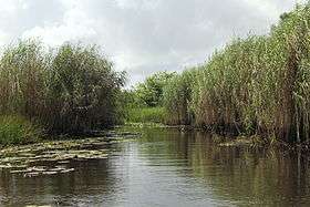
The Nariva Swamp on the mouth of the Ortoire river in Trinidad.
The Ortoire River is the largest river in Trinidad and Tobago. It forms the boundary between Nariva County and Mayaro County in east Trinidad.

Ortoire River - This shell-lined beach is near to the mouth of the river where it enters the Atlantic Ocean on Trinidad's east coast

Ortoire River - The village of Mafeking at the mouth of the river where it enters the Atlantic Ocean on Trinidad's east coast

Ortoire River - The river drains the Nariva Swamp where the protected can be found in small numbers

Ortoire River - The mouth of the river where it enters the Atlantic Ocean on Trinidad's east coast

Ortoire River - The fishing village of Mafeking lies at the mouth of the river where it enters the Atlantic Ocean on Trinidad's east coast. The river drains the Nariva Swamp
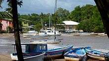
Ortoire River - The fishing village of Mafeking at the mouth of the river where it enters the Atlantic Ocean on Trinidad's east coast
It is green in color and it once had an iron bridge with wooden planks but it has been replaced by an all paved concrete bridge; also it was made higher to reduce flooding. The river is famous for giving off light which usually appears blue in color every 10 years, this is due to the bioluminescence of living organisms residing in the water.
Coordinates: 10°20′N 61°00′W / 10.333°N 61.000°W
This article is issued from Wikipedia - version of the 7/26/2016. The text is available under the Creative Commons Attribution/Share Alike but additional terms may apply for the media files.