Orosí
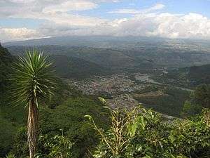
Orosi is a town in the Cartago Province in Costa Rica, about 35 kilometers south of the capital San José. Orosi is situated on the Reventazón River in the Orosi Valley a deep valley and humid climate, surrounded by hills and lush vegetation. The cultivation of coffee is the leading industry in the area. Orosi has a population of approximately 4,600 and has the oldest Catholic church still in use in Costa Rica. The church, Iglesia de San Jose de Orosi, was built in 1743 during the Colony.
With its rain forests, volcanoes, hills and valleys lined with rows upon rows of coffee plants and sugar cane, the Orosi region offers some of the richest scenery to be found in Costa Rica. But the region is also rich in history and contains a number of monuments to the past, including a colonial capital founded in 1563 and archeological excavations that date back to 1000 B.C. Although this area was one of the first in the country to be settled, it has been one of the last to be developed for tourism.
A few kilometers away, at the southern end of the valley, the road ends and the Parque Nacional Tapantí Macizo Cerro de la Muerte begins. This park covers about 600 km² and forms the northernmost section of a massive collection of nature parks that extends into Panamá (the largest of which is the Parque Internacional La Amistad). As a result, wildlife abounds. However, access is difficult and largely restricted apart from a few kilometers of easy trails. The abundance of birds makes it a popular place for ornithology studies. Part of the reason for the abundant growth is the heavy rainfall, which ranges up to 7000 mm in the mountains, it is the drinkable water source that supplies much of the metropolitan area is maintained.. Lago de Cachi lies to the northeast.


History
Orosi is one of the oldest communities in Costa Rica. Before the arrival of the Spanish in the sixteenth century, the Orosi Valley was inhabited by the indigenous Huetare, Cabecar and Viceita tribes.[1]
Location
Taking as starting point the City of San José is possible to drive through the Florencio del Castillo highway to Cartago where the Basilica of the Angels is located. Leaving the City of Cartago southeast course you pass Paraiso. Arriving in Paraiso de cartago take the road to Orosi Valley where Reventazón River is located.[2]
References
Sources
External links
Coordinates: 9°48′N 83°51′W / 9.800°N 83.850°W