Orcas Island
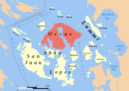 Location of Orcas Island in the San Juan Islands | |
 Orcas | |
| Geography | |
|---|---|
| Location | Pacific Northwest |
| Coordinates | 48°39′15″N 122°56′18″W / 48.65417°N 122.93833°WCoordinates: 48°39′15″N 122°56′18″W / 48.65417°N 122.93833°W |
| Archipelago | San Juan Islands |
| Area | 57.3 sq mi (148 km2) |
| Highest elevation | 2,409 ft (734.3 m) |
| Highest point | Mount Constitution |
| Administration | |
|
United States | |
| State | Washington |
| County | San Juan County |
| Largest settlement | Eastsound |
| Demographics | |
| Population | 5,387 (2010) |
| Pop. density | 30.09 /km2 (77.93 /sq mi) |
Orcas Island (/ˈɔːrkᵻs/, like Orcus, not /ˈɔːrkəz/, as in the plural of orca) is the largest of the San Juan Islands, which are located in the northwestern corner of Washington state in San Juan County, Washington, United States.
History
The name "Orcas" is a shortened form of Horcasitas, or Juan Vicente de Güemes Padilla Horcasitas y Aguayo, 2nd Count of Revillagigedo, the Viceroy of Mexico who sent an exploration expedition under Francisco de Eliza to the Pacific Northwest in 1791. During the voyage, Eliza explored part of the San Juan Islands. He did not apply the name Orcas specifically to Orcas Island, but rather to part of the archipelago. In 1847, Henry Kellett assigned the name Orcas to Orcas Island during his reorganization of the British Admiralty charts. Kellett's work eliminated the patriotically American names that Charles Wilkes had given to many features of the San Juans during the Wilkes Expedition of 1838–1842. Wilkes had named Orcas Island "Hull Island", after Commodore Isaac Hull. Other features of Orcas Island named by Wilkes include "Ironsides Inlet" for East Sound and "Guerrier Bay" for West Sound. One of the names Wilkes gave remains: Mount Constitution. Wilkes' names follow a pattern: Isaac Hull was the commander of "Old Ironsides" (the USS Constitution) and won fame after capturing the British warship Guerriere in the War of 1812.[1]
Geography
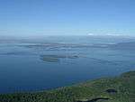
With a land area of 57.3 square miles (148.4 km²) and a population of 5,387 (2010 census), Orcas Island is slightly larger, but less populous, than neighboring San Juan Island. Orcas is shaped like a pair of saddlebags, separated by fjord-like Eastsound, with Massacre Bay on the south side, and tiny Skull Island just off the coast. At the northern end of the island is the village of Eastsound, the largest population center on Orcas and the second largest in San Juan County. In 1989, the people of San Juan County asked the federal government to purchase a Lummi Nation site on Orcas Island's Madrona Point in Eastsound. The land was given to the Lummi who agreed to operate it as Madrona Point Park, a private preserve characterized by hundreds of twisting madrona trees sprouting from the rocky shoreline. Several years ago, the Lummi tribe declared the land sacred ancestral burial grounds and the park was closed following incidents of vandalism. Public access has been denied since that time.
Other, smaller towns - or hamlets - on the island include Orcas (where the inter-island/mainland ferry lands), West Sound (technically part of Eastsound), Deer Harbor, Rosario (technically part of Eastsound), Olga and Doe Bay. There are a number of former settlements that no longer exist, which were mostly built up around the lime kiln industry, including Ocean, Newhall, and Dolphin Bay.
Orcas Island is accessible by air via Eastsound Airport or water landings by seaplane as well as by water via the Washington State Ferry system or private watercraft. During the summer season, there is an island shuttle that runs from the ferry landing to Eastsound and other points.
Island access and sights
The state supports island access through the Washington State Ferries system. In addition, the island can be accessed through a variety of private air and sea charter services.
- The Orcas Island Historical Museum is located down town Eastsound and is the only object-based, interpretive heritage facility for the island, with a permanent collection containing approximately 6000 objects, paper documents and photographs.
- Orcas Island is also home to three historic camps: Camp Orkila, Four Winds Westward Ho and Camp Indralaya.
- The Lambiel Museum is a small private collection in the home of local resident Leo Lambiel. Lambiel's museum contains a collection of works inspired by the San Juan Islands, including works by Helen Loggie. The museum is open to the public by appointment.[2]
Public services
The Orcas Island School District operates three schools: Orcas Island Elementary School housed in the island's historic Nellie S. Milton school building; Orcas Island Middle School; and Orcas Island High School. All of the island's public schools are located in Eastsound.
The Orcas Island Public Library is located in Eastsound and serves a population of approximately 5,000 card holders. The Orcas Island Library District is a junior-taxing district that funds the Orcas Island Public Library's operating budget through property taxes. The annual Library Fair sells books donated by Orcas Island residents and visitors, the proceeds of which are donated back to the Library's operating budget. The Library also sponsors lifelong learning classes, the Crossroads lecture series, Sustainable Orcas Island, as well as other community outreach programs.
Moran State Park
Mount Constitution (elevation 2409 feet - 734 meters) is the highest point in the San Juan islands. The mountain is part of Moran State Park, the largest public recreation area in the San Juan Islands. Moran State Park encompasses over 5,000 acres (2,000 ha) of woodland and has several lakes and numerous waterfalls. The park was given to the Island.
References
- ↑ Phillips, James W. (1971). Washington State Place Names. University of Washington Press. ISBN 0-295-95158-3.
- ↑ Lambiel Museum at Sunset Magazine website - sunset.com
External links
| Wikimedia Commons has media related to Orcas Island. |
- Orcas Island Chamber of Commerce (Orcas Island)
- Orcas Island Heritage
- Orcas Island Historical Museum
- Orcas Island at DMOZ
- Orcas Island
- Orcas Today